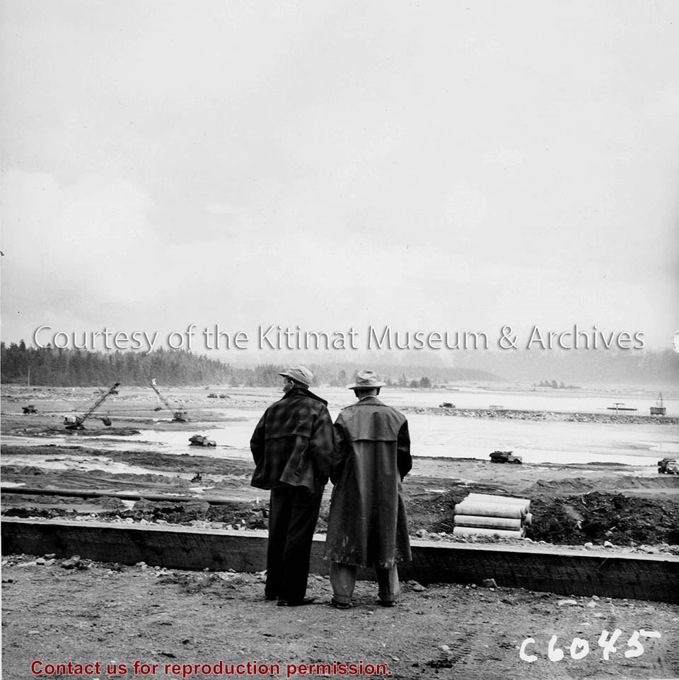
Photo depicts Kitimat Constructors Project Manager Hal Whiting on right, standing beside a unidentified man. Both watch the construction activity occurring down on the tidal flats in front of them, site for the smelter.
Photo depicts Kitimat Constructors Project Manager Hal Whiting on right, standing beside a unidentified man. Both watch the construction activity occurring down on the tidal flats in front of them, site for the smelter.
Notes
Title based on content of photograph. -- Photographed by the International Harvester Company, manufacturers of construction equipment purchased for the Project. Hal Whiting Collection 985.65.99
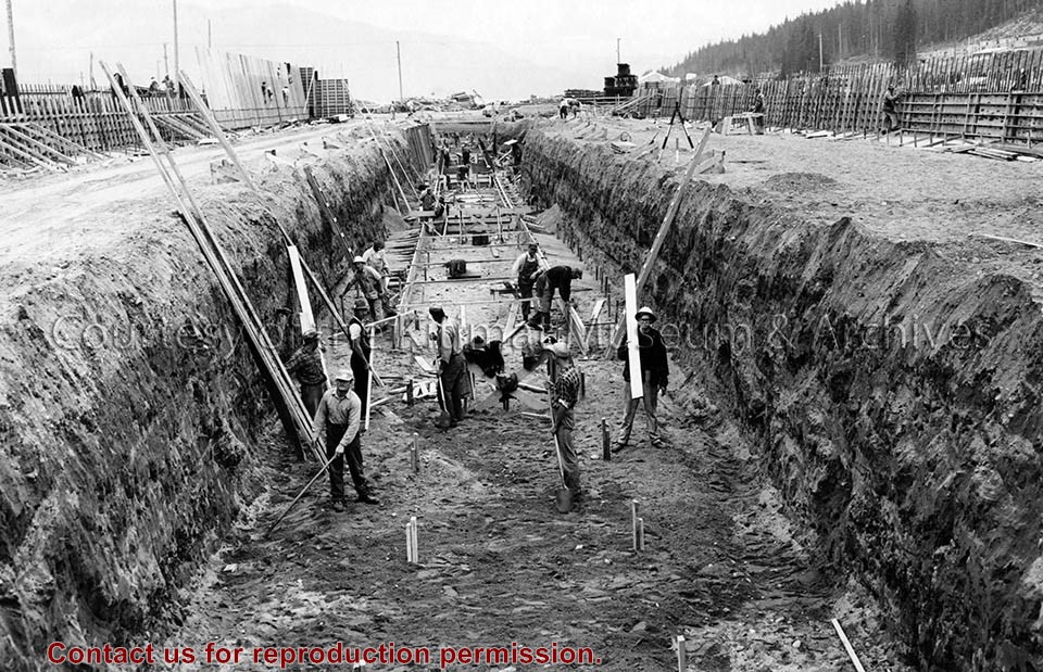
Photo depicts workers excavating for the construction of the alumina storage building.
Notes
Title based on content of photograph. -- Alcan ID No. BC-2-451. -- Sloping sides avoided cave-ins. -- Hal Whiting was Project Manager, Kitimat Constructors, for smelter and town construction. Hal Whiting Collection 985.65.267
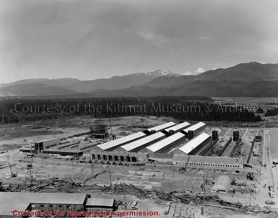
Photograph of smeltersite looking northeast, showing service buildings at left, rectifier building #102 and potline #2, pre-cast concrete yard in foreground.
Bud Powell is a longtime resident of Kitimat and former smeltersite resident. He worked for Alcan.
Custodial History
Donated by Bud Powell.
Scope and Content
Photograph of smeltersite looking northeast, showing service buildings at left, rectifier building #102 and potline #2, pre-cast concrete yard in foreground.
Photograph of view looking north-east over initial area cleared for smelter service building construction. Light area has been gravel filled, dark area overburden to be stripped. Trucks and machinery visible at work.
Bud Powell is a longtime resident of Kitimat and former smeltersite resident. He worked for Alcan.
Custodial History
Donated by Bud Powell.
Scope and Content
Photograph of view looking north-east over initial area cleared for smelter service building construction. Light area has been gravel filled, dark area overburden to be stripped. Trucks and machinery visible at work.
Photograph of aerial of hauling, levelling, and compacting of the fill in the smelter area. Looking South. Trucks and machines visible along with wheel tracks in the dirt.
Bud Powell is a longtime resident of Kitimat and former smeltersite resident. He worked for Alcan.
Custodial History
Donated by Bud Powell.
Scope and Content
Photograph of aerial of hauling, levelling, and compacting of the fill in the smelter area. Looking South. Trucks and machines visible along with wheel tracks in the dirt.
Photograph of aerial view of neighbourhood C. Note debris piles and logs in area C-II in the foreground. Kitlope, Kootney, Capilano, snd Babine streets visible with completed homes.
Land clearing of Kitimat. All aerials for development.
Custodial History
From the files of Ray Hunstone. Photos from an Alcan binder, have Alcan numbers.
Scope and Content
Photograph of aerial view of neighbourhood C. Note debris piles and logs in area C-II in the foreground. Kitlope, Kootney, Capilano, snd Babine streets visible with completed homes.
Photograph of aerial view looking south-west across Teal and Swallow Streets towards the Nechako Centre School and commercial buildings in neighbourhood A-I. Many houses still under construction. Portables can be seen outside Nechako School.
Donated by Jackie Worboys. Given to the Jackie Mufford Worboys family by Wally Melville.
Scope and Content
Photograph of aerial view looking south-west across Teal and Swallow Streets towards the Nechako Centre School and commercial buildings in neighbourhood A-I. Many houses still under construction. Portables can be seen outside Nechako School.
Photograph of aerial view looking west showing C-II clearing in lower left hand corner, low rental housing area and neighbourhood C-I in centre, and new camp site clearing left-centre. Camp is at Riverlodge site. Kitimat River bridge visible behind. Lots of snow on ground.
Donated by Jackie Worboys. Given to the Jackie Mufford Worboys family by Wally Melville.
Scope and Content
Photograph of aerial view looking west showing C-II clearing in lower left hand corner, low rental housing area and neighbourhood C-I in centre, and new camp site clearing left-centre. Camp is at Riverlodge site. Kitimat River bridge visible behind. Lots of snow on ground.
Photograph of aerial of east side of Nechako area. Widgeon, Wren, Apartments, Partridge, and Pintail in foreground with more streets behind. Houses are built.
Donated by Jackie Worboys. Given to the Jackie Mufford Worboys family by Wally Melville.
Scope and Content
Photograph of aerial of east side of Nechako area. Widgeon, Wren, Apartments, Partridge, and Pintail in foreground with more streets behind. Houses are built.
Photograph of aerial of west side of Nechako area. Petrel, Plover, Aprtments, Osprey and Oriole in foreground with more streets behind. Houses are built. Fire station, United Church, Nechako Centre and School are visible.
Donated by Jackie Worboys. Given to the Jackie Mufford Worboys family by Wally Melville.
Scope and Content
Photograph of aerial of west side of Nechako area. Petrel, Plover, Aprtments, Osprey and Oriole in foreground with more streets behind. Houses are built. Fire station, United Church, Nechako Centre and School are visible.
Photograph of aerial of Starling, Swallow, and Teal Streets. Please note the floor slabs poured and houses under construction by N.W. Hullah Construction Limited.
Donated by Jackie Worboys. Given to the Jackie Mufford Worboys family by Wally Melville.
Scope and Content
Photograph of aerial of Starling, Swallow, and Teal Streets. Please note the floor slabs poured and houses under construction by N.W. Hullah Construction Limited.