Photograph of Lakelse campsite after slide. Aerial shot above shows the layout of the government campsite and path of the slide through the southern part. Parking units in the lower foreground right are seen to have been relatively undisturbed by the slide when this picture was taken late Thursday afternoon. Damage to new road construction, upper left, is clearly seen.
Photograph of Lakelse campsite after slide. Aerial shot above shows the layout of the government campsite and path of the slide through the southern part. Parking units in the lower foreground right are seen to have been relatively undisturbed by the slide when this picture was taken late Thursday afternoon. Damage to new road construction, upper left, is clearly seen.
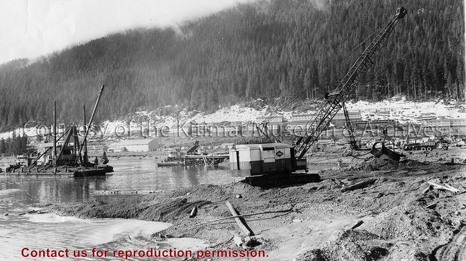
Photo depicts the dredge and dragline excavating the channel from the dock to deep water, a truck dumping gravel for the foundation blanket into the bottom of a dump scow. The view looks toward the construction site for the permanent wharf from the south dike of the graving dock, crew bunkhouses of Smeltersite in the background.
Photo depicts the dredge and dragline excavating the channel from the dock to deep water, a truck dumping gravel for the foundation blanket into the bottom of a dump scow. The view looks toward the construction site for the permanent wharf from the south dike of the graving dock, crew bunkhouses of Smeltersite in the background.
Notes
Title based on content of photograph. -- Alcan ID No. BC-2-320. Hal Whiting Collection 985.65.211
Jamieson came to Kitimat from Vancouver to work on the Alcan project in 1952. With his first pay cheque he bought a small "Pony Kodak" camera at the local store (Hudson Bay?), and started taking coloured slides of the Kitimat from 1952-1953. Left Kitimat at the end of August 1953 to move to Montreal.
Scope and Content
Slide of Kitimat permanent dock and rec hall from bunkhouse #8.