Photograph of an aerial of the Kitimat Townsite. View is looking across the full town towards Douglas Channel. Hirsch Creek is visible in front of the town.
Photograph of an aerial of the Kitimat Townsite. View is looking across the full town towards Douglas Channel. Hirsch Creek is visible in front of the town.
Photograph of an aerial of the Kitimat Townsite. View is looking across the full town towards Douglas Channel. Hirsch Creek and Cable Car are visible in the foreground.
Photograph of an aerial of the Kitimat Townsite. View is looking across the full town towards Douglas Channel. Hirsch Creek and Cable Car are visible in the foreground.
Photograph of aerial of the Kitimat townsite. View is looking over the Kildala neighbourhood with City Centre and the hospital visible beyond. Nechako and Whitesail neighbourhoods can be seen up on the hill. Mountains behind the town look clearcut. Mount Elizabeth furthest back in background.
Photograph of aerial of the Kitimat townsite. View is looking over the Kildala neighbourhood with City Centre and the hospital visible beyond. Nechako and Whitesail neighbourhoods can be seen up on the hill. Mountains behind the town look clearcut. Mount Elizabeth furthest back in background.
Aerial photo of the Kitimat river estuary showing Kitimat River, Kitimat Harbor, Minette Bay, and the Alcan company smelter site taken from the southwest looking northeast towards the Kitimat City Centre.
Aerial photo of the Kitimat river estuary showing Kitimat River, Kitimat Harbor, Minette Bay, and the Alcan company smelter site taken from the southwest looking northeast towards the Kitimat City Centre.
The Kitimat River Bridge is running diagonally across the right side of the photograph. There are buildings positioned in the shape of a horseshoe at the bottom right of the picture, and to the left of that are trees relatively spread apart.
The Kitimat River Bridge is running diagonally across the right side of the photograph. There are buildings positioned in the shape of a horseshoe at the bottom right of the picture, and to the left of that are trees relatively spread apart.
Photograph of an aerial view the the Alcan plant and Kitimat River Delta. Alcan plant is visible above while the delta is below.
Notes
Back of photo has 2 dates, Jan 23 1985 and Jan 23 1986. The 1986 date is a sticker add on, while the 1985 date is stamped on. The 1985 date is believed to be correct.
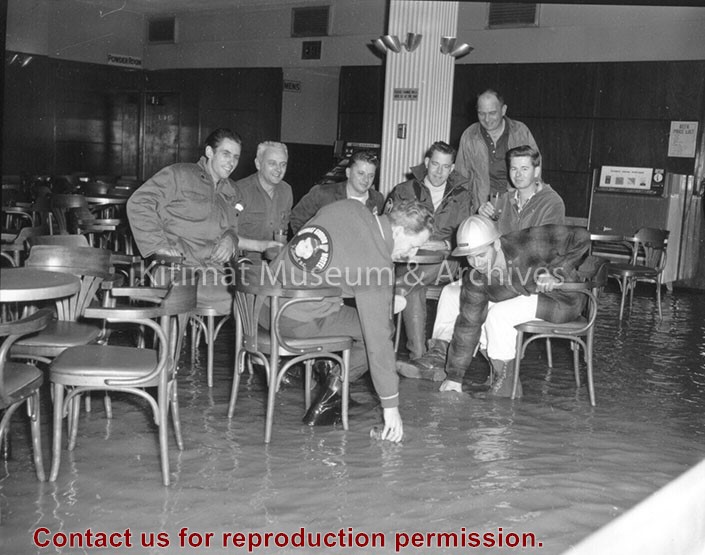
Hotel Manager George More is seen with some of the boys around 6 a.m. in the Gordon's main beverage room. Flood waters covered the tiled floor to a depth of several inches. Clean-up crews were on the job before noon and the hotel was back in business the same day, reflecting the swiftness with which the water dropped.
Hotel Manager George More is seen with some of the boys around 6 a.m. in the Gordon's main beverage room. Flood waters covered the tiled floor to a depth of several inches. Clean-up crews were on the job before noon and the hotel was back in business the same day, reflecting the swiftness with which the water dropped.