Map, of the District Municipality of Kitimat, British Columbia, drawn by G.V. Laurenson, May 1955 for Hudson's Bay Company. 1st. Edition.Map includes Neighborhood 'A' or 'Nechako', Kitimat Service Center, Aluminum Company of Canada Ltd.'s B.C. Project, Nechako Center, Kitimat City Center and a Reference section.
Map, of the District Municipality of Kitimat, British Columbia, drawn by G.V. Laurenson, May 1955 for Hudson's Bay Company. 1st. Edition.Map includes Neighborhood 'A' or 'Nechako', Kitimat Service Center, Aluminum Company of Canada Ltd.'s B.C. Project, Nechako Center, Kitimat City Center and a Reference section.
Photograph of Aerial View of Kildala Neighborhood ; Nechako Neighborhood ; City Centre ; Haisla Bridge ; Kitimat River ; Riverlodge Camp ; Parks and Campgrounds ; Municipal ; Radley Park
Map of Kitimat, Coast District Range 5, Department of Lands and Forests, 1956-1957. Map shows early construction camps, Nechako neighbourhood, Reservations, all topography references.
Map of Kitimat, Coast District Range 5, Department of Lands and Forests, 1956-1957. Map shows early construction camps, Nechako neighbourhood, Reservations, all topography references.
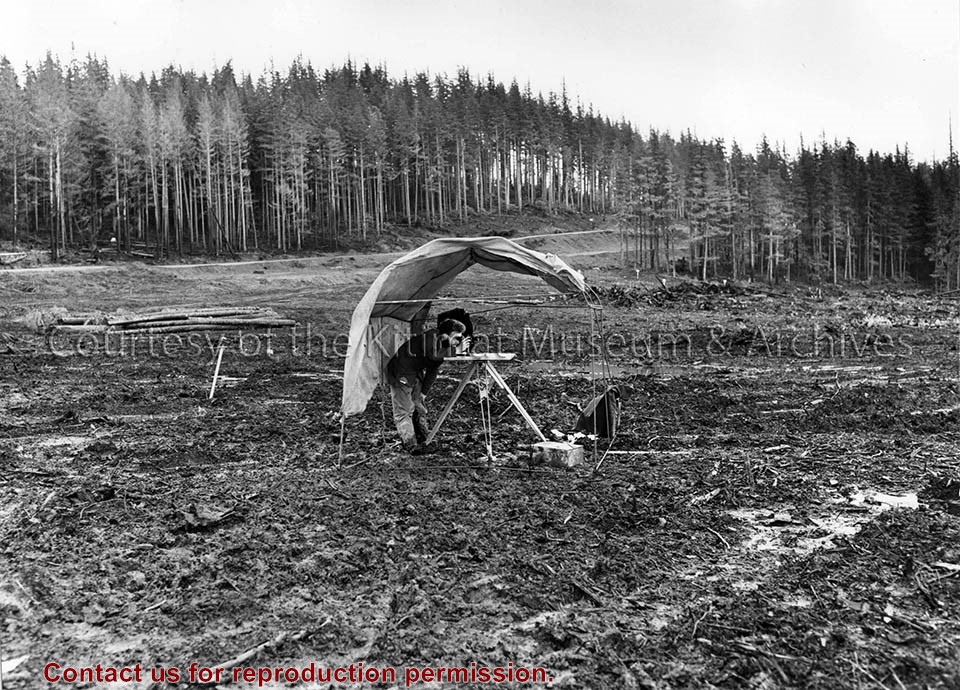
Northern Sentinel: Box #4: (A) Historical (1) District of Kitimat (a) Town Planning (i) Mayer, Whittlesey and Glass, New York (ii) Resident Planning Engineer
Scope and Content
Photo showing (Municipal) map of area of the corporation of the District of Kitimat.
There is an apartment complex at the bottom left hand side of the photograph, with the United Church of Canada to the right of it. To the right of the church is Kingfisher Avenue.
There is an apartment complex at the bottom left hand side of the photograph, with the United Church of Canada to the right of it. To the right of the church is Kingfisher Avenue.
Photograph showing two women looking at a map. One of the women is wearing a scarf over her hair and a coat, the other woman is wearing a knit button up sweater. Both of them are wearing glasses. In the foreground of the women, there is a projector sitting on a table. Part of the Loggers Supplement 1972.
Photograph showing two women looking at a map. One of the women is wearing a scarf over her hair and a coat, the other woman is wearing a knit button up sweater. Both of them are wearing glasses. In the foreground of the women, there is a projector sitting on a table. Part of the Loggers Supplement 1972.
Photograph of the Duke of Edinburgh viewing the map of a new town in Canada familiar to him-Kitimat.
Notes
Picture above shows the Duke of Edinburgh viewing the map of a new town in Canada familiar to him- Kitimat. He opened the Aluminum Company of Canada, limited's smelter here on his tour of Canada in 1954. By Henry Strub, staff member of Aluminum Secretariat Limited of Montreal, who has been in Brussels in connection with Alcan's exhibit at the world's Fair.
Photo showing one of the first lots of area grown produce destined for the Kitimat Market (1958). No name - forerunner of 'Terrace Farmers' Market' - lower city centre showing a truckload of cabbages.
#3 Northern Sentinel: Box #2: (A) Historical - 1st lot of area - grown produce
Scope and Content
Photo showing one of the first lots of area grown produce destined for the Kitimat Market (1958). No name - forerunner of 'Terrace Farmers' Market' - lower city centre showing a truckload of cabbages.
Photograph of two older men standing together in the foreground of a map of British Columbia. Both of the men are wearing glasses, dark blazers, button up shirts and dress pants. In the foreground, there is a type writer.
Photograph of two older men standing together in the foreground of a map of British Columbia. Both of the men are wearing glasses, dark blazers, button up shirts and dress pants. In the foreground, there is a type writer.