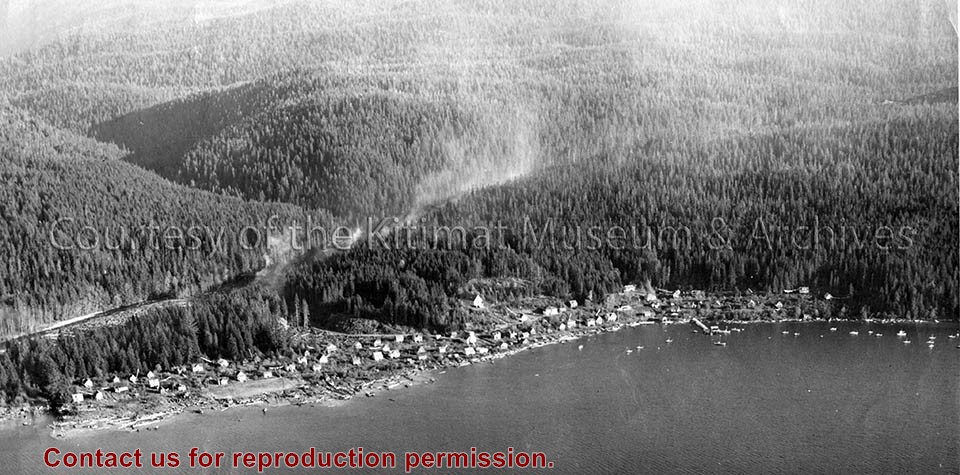
Photo depicts a slash burning on the transmission line right-of-way behind Kitamaat Village.
Notes
Title based on content of photograph. Fred DeLory, Alcan's Resident Engineer at smeltersite, was one of two who signed the incorporation papers for the town of Kitimat. Fred DeLory Collection 2002.15
Photograph of aerial photograph taken from over townsite camp looking toward City Centre showing extent of clearing in C-I area. Haisla Blvd. can be seen on left-hand side of the picture. At bottom a single structure can be seen. Some snow is behind it. In the very back Douglas Channel is visible.
Donated by Jackie Worboys. Given to the Jackie Mufford Worboys family by Wally Melville.
Scope and Content
Photograph of aerial photograph taken from over townsite camp looking toward City Centre showing extent of clearing in C-I area. Haisla Blvd. can be seen on left-hand side of the picture. At bottom a single structure can be seen. Some snow is behind it. In the very back Douglas Channel is visible.
Alice Dicker's father, Benard, came to Canada to work in 1955. He was a forman D-shift for Alcan. He married Anna in 1959. Alice and her sister Claudia were born in Kitimat and the family lived here until 1969, at which time they returned to Germany.
Scope and Content
Photograph of view from a field looking across Kitimat neighbourhoods and homes.
Photograph of aerial view looking south showing overall view of potline group "B" and part of group "A". Further potlines look completed, and closer ones still under construction. Cleared area with building material in front.
Bud Powell is a longtime resident of Kitimat and former smeltersite resident. He worked for Alcan.
Custodial History
Donated by Bud Powell.
Scope and Content
Photograph of aerial view looking south showing overall view of potline group "B" and part of group "A". Further potlines look completed, and closer ones still under construction. Cleared area with building material in front.
Photograph of aerial view of neighbourhood C. Note debris piles and logs in area C-II in the foreground. Kitlope, Kootney, Capilano, snd Babine streets visible with completed homes.
Land clearing of Kitimat. All aerials for development.
Custodial History
From the files of Ray Hunstone. Photos from an Alcan binder, have Alcan numbers.
Scope and Content
Photograph of aerial view of neighbourhood C. Note debris piles and logs in area C-II in the foreground. Kitlope, Kootney, Capilano, snd Babine streets visible with completed homes.
Photograph of aerial view looking south-west across Teal and Swallow Streets towards the Nechako Centre School and commercial buildings in neighbourhood A-I. Many houses still under construction. Portables can be seen outside Nechako School.
Donated by Jackie Worboys. Given to the Jackie Mufford Worboys family by Wally Melville.
Scope and Content
Photograph of aerial view looking south-west across Teal and Swallow Streets towards the Nechako Centre School and commercial buildings in neighbourhood A-I. Many houses still under construction. Portables can be seen outside Nechako School.
Alice Dicker's father, Benard, came to Canada to work in 1955. He was a forman D-shift for Alcan. He married Anna in 1959. Alice and her sister Claudia were born in Kitimat and the family lived here until 1969, at which time they returned to Germany.
Scope and Content
Photograph of view of City Centre and Kildala neighbourhood.
Alice Dicker's father, Benard, came to Canada to work in 1955. He was a forman D-shift for Alcan. He married Anna in 1959. Alice and her sister Claudia were born in Kitimat and the family lived here until 1969, at which time they returned to Germany.
Scope and Content
Photograph of view of City Centre and Hudson's Bay building. Houses and Kildala School in background.
Photograph of aerial photograph looking east toward neighbourhood A with the City Centre clearing in the right-hand foreground and neighbourhood A-IV clearing in the centre foreground.
Donated by Jackie Worboys. Given to the Jackie Mufford Worboys family by Wally Melville.
Scope and Content
Photograph of aerial photograph looking east toward neighbourhood A with the City Centre clearing in the right-hand foreground and neighbourhood A-IV clearing in the centre foreground.
Photograph of showing paving machine in operation on Haisla Blvd. between Nalabila and Kingfisher Ave. Six men visible working, with two operating paving vehicles. Side of paving machine reads "Barber Greene".
Donated by Jackie Worboys. Given to the Jackie Mufford Worboys family by Wally Melville.
Scope and Content
Photograph of showing paving machine in operation on Haisla Blvd. between Nalabila and Kingfisher Ave. Six men visible working, with two operating paving vehicles. Side of paving machine reads "Barber Greene".
Photograph of aerial view of City Centre and neighbourhood C-I. Please note stripping in progress in City Centre. Douglas Channel visible in background. There is an arrow pointing to the lower right side with a note saying "fire was in this felled area shown here. Got partly into the standing timber also."
Donated by Jackie Worboys. Given to the Jackie Mufford Worboys family by Wally Melville.
Scope and Content
Photograph of aerial view of City Centre and neighbourhood C-I. Please note stripping in progress in City Centre. Douglas Channel visible in background. There is an arrow pointing to the lower right side with a note saying "fire was in this felled area shown here. Got partly into the standing timber also."