These eleven black and white glossy photographs were donated to the Museum with compliments of Malax Photographs LTD for use in our main floor exhibit "Kitimat: City of Tomorrow"
These eleven black and white glossy photographs were donated to the Museum with compliments of Malax Photographs LTD for use in our main floor exhibit "Kitimat: City of Tomorrow"
Physical Condition
good
Material
paper
Condition Remarks
Photographs are professionally done. All done in B/W
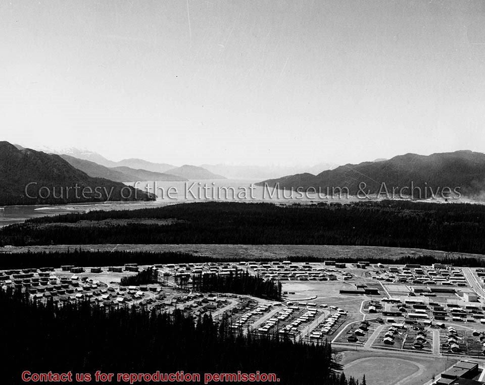
Photo depicts Nechako Neighbourhood, swath of land cleared for Neighbourhood "D", and Douglas Channel in the background, smelter on the right.
Notes
Famed Canadian documentary photographer Malak Karsh was hired in the 1950s by Alcan to take photographs of Arvida and Kitimat. Many were published in Alcan literature and textbooks on Canada. A colourized version of this photograph appears on the cover of the Canadian Geographical Journal, November 1959, Vol. LIX No.5. Northern Sentinel Press Collection
Subdivision plan of part of district lots 6038, 6039 and part of block 29, plan 3435 range 5, Coast District. District Municipality of Kitimat. Plan 4228. November 5, 1961.
Plan of subdivision of parts of D.L. 6046 & west half of D.L. 6045, and parcel. "X" (former block 78 and adjoining road plan 3549) range 5, Coast District. District Municipality of Kitimat. Plan 4639. August 27, 1963.
Plan of portions of block 29 map 3435 district lots 6038, 6039, 6042 & 6043 range 5, Coast District. District Municipality of Kitimat. Plan 3743. November 4, 1957.
Donated by Rick Wozney. Aluminum Company of Canada, Limited (Registered Owner).
Scope and Content
District of Kitimat lot and block plans.
Subdivision plan of part of district lots 6038, 6039 and part of block 29, plan 3435 range 5, Coast District. District Municipality of Kitimat. Plan 4228. November 5, 1961.
Plan of subdivision of parts of D.L. 6046 & west half of D.L. 6045, and parcel. "X" (former block 78 and adjoining road plan 3549) range 5, Coast District. District Municipality of Kitimat. Plan 4639. August 27, 1963.
Plan of portions of block 29 map 3435 district lots 6038, 6039, 6042 & 6043 range 5, Coast District. District Municipality of Kitimat. Plan 3743. November 4, 1957.
Photographs of early Kitimat and Alcan smelter. Souvenir photobook with five photos.
Townsite with Mount Elizabeth in background. Smoke is visible beyond townsite in the forest. May 15, 1956.
Townsite with sandhill visible in background. May 15, 1956.
Main Road - Motel - Townsite. View of road leading from service centre into town. Kildala area cleared but not much is built. Kitimat River bridge visible at bottom. Aug 1955.
Kitimat Valley. View of Alcan site, hospital beach, and pier. Looking north.
Smeltersite. View of Alcan smelter and smeltersite.
Donated by Carol Larson. Originally belonged to her mother, Lydia Strecheniuk.
Scope and Content
Photographs of early Kitimat and Alcan smelter. Souvenir photobook with five photos.
Townsite with Mount Elizabeth in background. Smoke is visible beyond townsite in the forest. May 15, 1956.
Townsite with sandhill visible in background. May 15, 1956.
Main Road - Motel - Townsite. View of road leading from service centre into town. Kildala area cleared but not much is built. Kitimat River bridge visible at bottom. Aug 1955.
Kitimat Valley. View of Alcan site, hospital beach, and pier. Looking north.
Smeltersite. View of Alcan smelter and smeltersite.
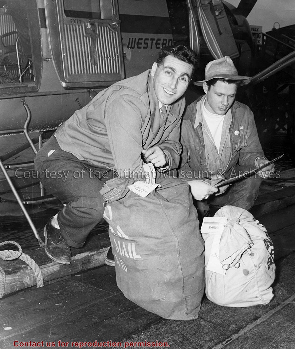
Photo depicts two men kneeling beside the first bags of mail to arrive via Pacific Western Airlines. On the right, Captain T. M. Kellough for PWA delivers the bags to on the left, Kitimat Express driver Lloyd Kaberg, at the wharf, Smeltersite. Northern Sentinel Press Collection
Photo depicts two men kneeling beside the first bags of mail to arrive via Pacific Western Airlines. On the right, Captain T. M. Kellough for PWA delivers the bags to on the left, Kitimat Express driver Lloyd Kaberg, at the wharf, Smeltersite. Northern Sentinel Press Collection
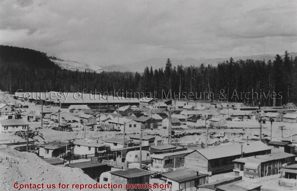
Photo depicts buildings at Anderson Hill Camp. Trailers and wash houses are in the foreground. The men's bunkhouses of Anderson Creek Camp are in the background.
Photo depicts buildings at Anderson Hill Camp. Trailers and wash houses are in the foreground. The men's bunkhouses of Anderson Creek Camp are in the background.
Notes
Title based on content of photograph. John Manders Collection
Base map of statistical area 6. The map shows Kitimat and surrounding coastal area. This map is a partial reproduction of the West Central British Columbia Base Map by Geographic Division, Surveys & Mapping Branch, Department of Lands, Forests, & Water Resources, Victoria, B.C. 1955-56.
Base map of statistical area 6. The map shows Kitimat and surrounding coastal area. This map is a partial reproduction of the West Central British Columbia Base Map by Geographic Division, Surveys & Mapping Branch, Department of Lands, Forests, & Water Resources, Victoria, B.C. 1955-56.