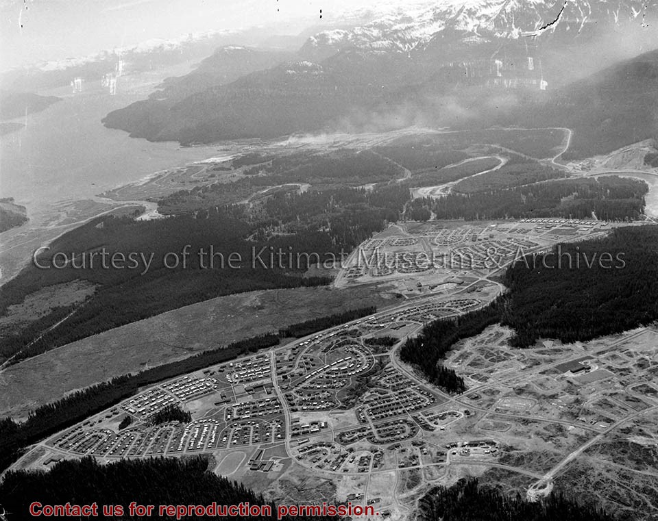
Photo depicts an aerial view of Kitimat, seen is land cleared for Neighbourhood "D" and the Whitesail neighbourhood under construction, right foreground. The Alcan smelter and channel are in the background.
Photo depicts an aerial view of Kitimat, seen is land cleared for Neighbourhood "D" and the Whitesail neighbourhood under construction, right foreground. The Alcan smelter and channel are in the background.
Notes
Title based on content of photograph. Max Patzelt Collection - 1998.1.8351
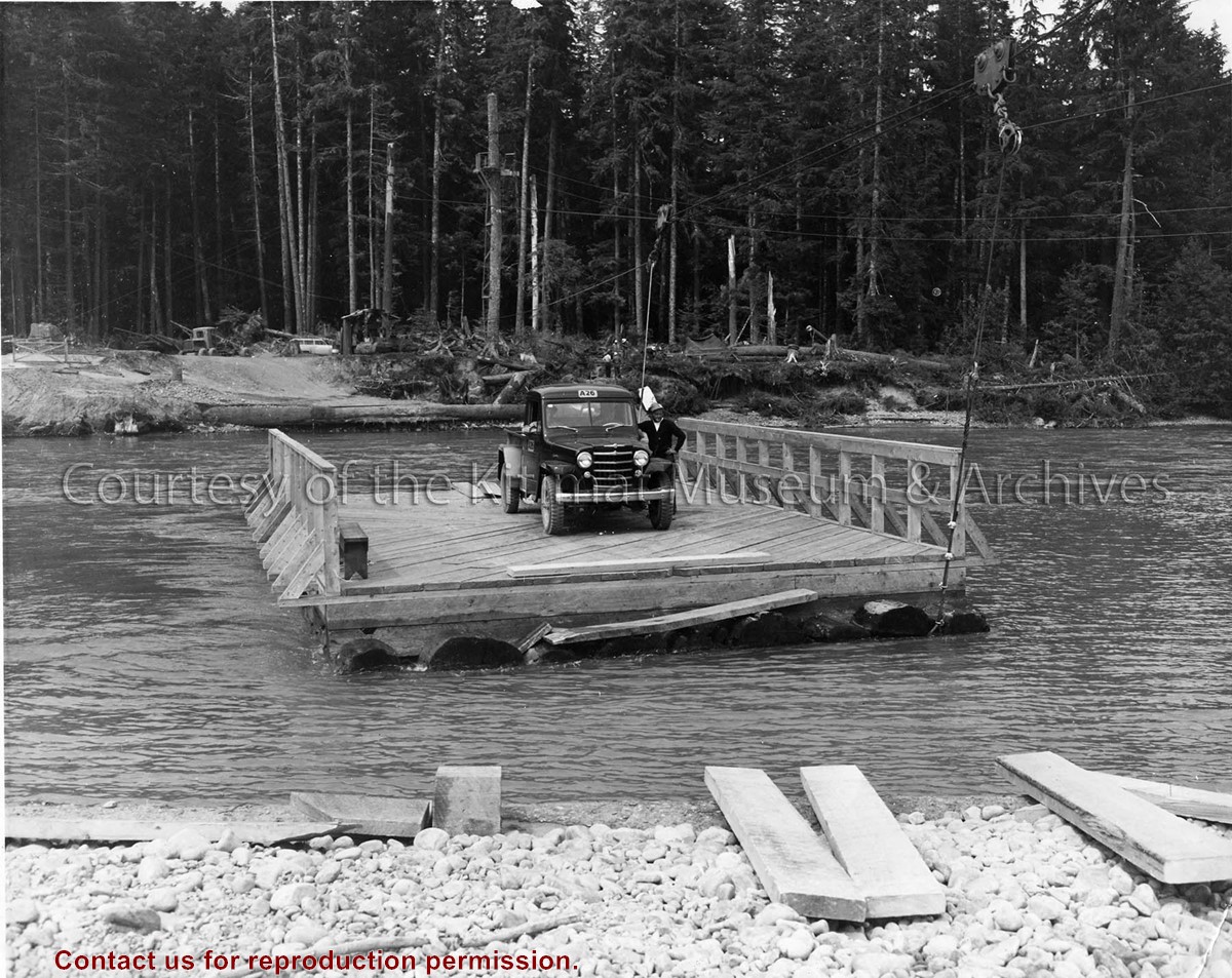
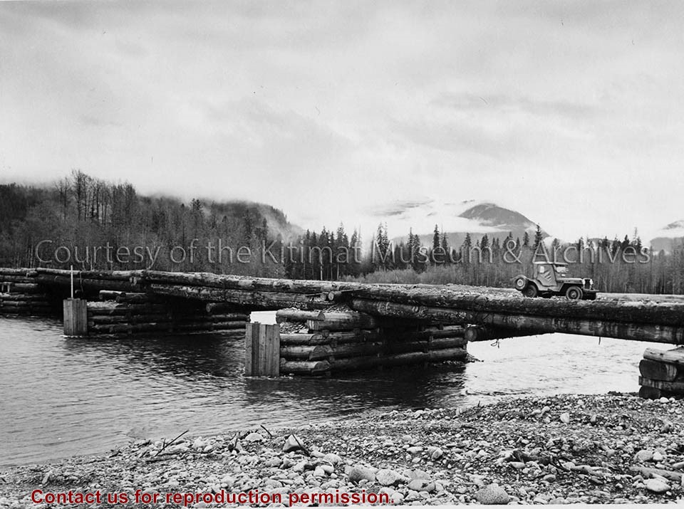
Photo depicts a man standing beside his truck, crossing the Kitimat River aboard a wood construction raft ferry, guard rail on two sides, and guided by a cabling system shown above the river.
Photo depicts a man standing beside his truck, crossing the Kitimat River aboard a wood construction raft ferry, guard rail on two sides, and guided by a cabling system shown above the river.
Notes
Title based on content of photograph. Alcan Collection 73.3.3.29
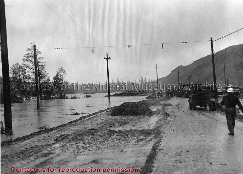
Photo depicts high water conditions of Kitimat River at the south end of Service Centre. Near the water's edge in the background is a truck that has overturned.
Photo depicts high water conditions of Kitimat River at the south end of Service Centre. Near the water's edge in the background is a truck that has overturned.
Notes
Title based on content of photograph. -- Alcan ID No. J-2-183. -- Alcan Public Relations Department ID No. ICT 349-1. Photograph taken at 2:30 p.m. Truck overturned when the road gave way. River elevation was 50.45 feet and rose to a maximum of 51.1 feet at 6:30 p.m. Alcan Collection 73.3.6.13
Photographs of the flood at Eurocan, the flood in the Kitimat River, flood in the Kitimat Village, Hirsch Creek Ball Field flood, Hirsch Creek Bridge, the Pumphouse flood in the Kitimat River, Lakelse Lake Park flood
Photographs taken by Gisela Mendel in her role as curator of the Kitimat Museum
Scope and Content
Photographs of the flood at Eurocan, the flood in the Kitimat River, flood in the Kitimat Village, Hirsch Creek Ball Field flood, Hirsch Creek Bridge, the Pumphouse flood in the Kitimat River, Lakelse Lake Park flood
Photographs of the Suskwa River taken near an old carrier village site. Also pictured is Pyrola Vireus Schweigg and Epilobium Angustifolium(Willow Herb).
Photographs taken by Gisela Mendel in her role as museum curator.
Scope and Content
Photographs of the Suskwa River taken near an old carrier village site. Also pictured is Pyrola Vireus Schweigg and Epilobium Angustifolium(Willow Herb).
Various types of wild plants in Kitimat such as Twisted Stalk, Queen's Cup, Fairy Bells, Baneberry, Elderberry, White Baneberry, White Heather, Rose Hips, Red-osier Dogwood, Wax Berry, Red Huckleberry, Thimble berry, Alaska Blueberries, Bunchberries, Cranberries, Sitka Mountain Ash, Creeping raspberry, and Mountain cranberry.
Photograph taken by Gisela Mendel in her role as museum curator.
Scope and Content
Various types of wild plants in Kitimat such as Twisted Stalk, Queen's Cup, Fairy Bells, Baneberry, Elderberry, White Baneberry, White Heather, Rose Hips, Red-osier Dogwood, Wax Berry, Red Huckleberry, Thimble berry, Alaska Blueberries, Bunchberries, Cranberries, Sitka Mountain Ash, Creeping raspberry, and Mountain cranberry.
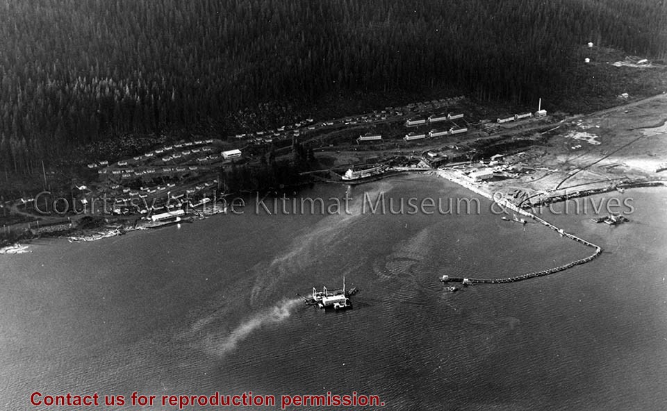
Photo depicts an aerial view of the smeltersite main camp showing married quarters, sternwheeler Delta King, hydraulic fill in progress, recreation building, hospital, power plant, sawmill and water tank.
Photo depicts an aerial view of the smeltersite main camp showing married quarters, sternwheeler Delta King, hydraulic fill in progress, recreation building, hospital, power plant, sawmill and water tank.
Notes
Title based on content of photograph. -- Alcan ID Numbers BC-2-243 and ACM-24311. Alcan Collection 78.11.32
Photo depicts an aerial view of a portion of the Nechako neighbourhood showing the Hullah prototype area, Pintail and Partridge streets, in the foreground.
Photo depicts an aerial view of a portion of the Nechako neighbourhood showing the Hullah prototype area, Pintail and Partridge streets, in the foreground.
Notes
Title based on content of photograph. District of Kitimat Collection
Photo depicts an aerial view looking northwest of Smeltersite housing, the hospital on the beach, the school in the centre, and the seaplane landing ramp.
Photo depicts an aerial view looking northwest of Smeltersite housing, the hospital on the beach, the school in the centre, and the seaplane landing ramp.
Notes
Title based on content of photograph. -- Alcan ID No. J-43-1837. Kitimat Heritage Advisory Commission Collection. KMA No. P00209.jpg