Photograph of looking west toward site of laboratory bldg. 273. Area clearcut. Cars on road on background. Powerlines along road. Something red is circled on the picture. Coordinate stake?
Bud Powell is a longtime resident of Kitimat and former smeltersite resident. He worked for Alcan.
Custodial History
Donated by Bud Powell.
Scope and Content
Photograph of looking west toward site of laboratory bldg. 273. Area clearcut. Cars on road on background. Powerlines along road. Something red is circled on the picture. Coordinate stake?
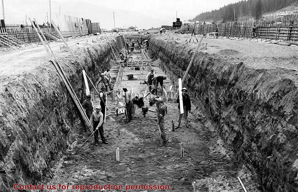
Photo depicts workers excavating for the construction of the alumina storage building.
Notes
Title based on content of photograph. -- Alcan ID No. BC-2-451. -- Sloping sides avoided cave-ins. -- Hal Whiting was Project Manager, Kitimat Constructors, for smelter and town construction. Hal Whiting Collection 985.65.267
Aerial view looking north at the plant site, with H.M.C.S. Sioux at the wharf. Tide elevation is approximately 2.5 feet, and the extent of the dredge cut in the harbour can be clearly seen.
In Klaus Mueller's possession when Engineering Depart. was dismantled.
Scope and Content
Aerial view looking north at the plant site, with H.M.C.S. Sioux at the wharf. Tide elevation is approximately 2.5 feet, and the extent of the dredge cut in the harbour can be clearly seen.
Photograph of looking northeast across part of neighbourhood 'C' towards Kitimat river bridge. Burning taking place in clearing for Riverlodge development. Winter.
Land clearing of Kitimat. All aerials for development.
Custodial History
From the files of Ray Hunstone. Photos from an Alcan binder, have Alcan numbers.
Scope and Content
Photograph of looking northeast across part of neighbourhood 'C' towards Kitimat river bridge. Burning taking place in clearing for Riverlodge development. Winter.
Photograph of looking north at coke calcining plant showing unloading hopper at left and concrete being placed at pier No.1. Cranes visible working. Lots of snow.
Bud Powell is a longtime resident of Kitimat and former smeltersite resident. He worked for Alcan.
Custodial History
Donated by Bud Powell.
Scope and Content
Photograph of looking north at coke calcining plant showing unloading hopper at left and concrete being placed at pier No.1. Cranes visible working. Lots of snow.
Photograph of aerial view looking west toward potline group B. Note sewer installed on cast side of terminal railway opposite potroom 8B. Storage area in foreground.
Bud Powell is a longtime resident of Kitimat and former smeltersite resident. He worked for Alcan.
Custodial History
Donated by Bud Powell.
Scope and Content
Photograph of aerial view looking west toward potline group B. Note sewer installed on cast side of terminal railway opposite potroom 8B. Storage area in foreground.
Photograph of aerial view looking west along Anderson Creek. Note very low flow in creek. Precast yard at left and construction shops at right. At centre is bridge across creek.
Bud Powell is a longtime resident of Kitimat and former smeltersite resident. He worked for Alcan.
Custodial History
Donated by Bud Powell.
Scope and Content
Photograph of aerial view looking west along Anderson Creek. Note very low flow in creek. Precast yard at left and construction shops at right. At centre is bridge across creek.
Photograph of smeltersite looking east. Service building area in middleground with pre-cast wall panels in place. Pre-cast concrete yard in foreground.
Bud Powell is a longtime resident of Kitimat and former smeltersite resident. He worked for Alcan.
Custodial History
Donated by Bud Powell.
Scope and Content
Photograph of smeltersite looking east. Service building area in middleground with pre-cast wall panels in place. Pre-cast concrete yard in foreground.
Photograph of aerial photograph looking west across neighbourhood C. Logs in lower right-hand corner are now being removed. In the background is the Riverlodge camp, with the dyke behind it. On top towards the right, the Kitimat River bridge is just visible.
Donated by Jackie Worboys. Given to the Jackie Mufford Worboys family by Wally Melville.
Scope and Content
Photograph of aerial photograph looking west across neighbourhood C. Logs in lower right-hand corner are now being removed. In the background is the Riverlodge camp, with the dyke behind it. On top towards the right, the Kitimat River bridge is just visible.
Photograph of aerial photograph looking east toward neighbourhood A with the City Centre clearing in the right-hand foreground and neighbourhood A-IV clearing in the centre foreground.
Donated by Jackie Worboys. Given to the Jackie Mufford Worboys family by Wally Melville.
Scope and Content
Photograph of aerial photograph looking east toward neighbourhood A with the City Centre clearing in the right-hand foreground and neighbourhood A-IV clearing in the centre foreground.