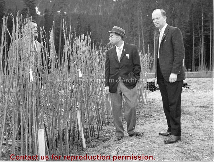
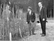
Photo showing Minori Nishi (centre) and his gift to the town: 300 Japanese flowering cherry trees. Norman Barber (left) and Municipal Manager Art Currie (right) looking on.
Photo showing Minori Nishi (centre) and his gift to the town: 300 Japanese flowering cherry trees. Norman Barber (left) and Municipal Manager Art Currie (right) looking on.
Photograph of an aerial view the the Alcan plant and Kitimat River Delta. Alcan plant is visible above while the delta is below.
Notes
Back of photo has 2 dates, Jan 23 1985 and Jan 23 1986. The 1986 date is a sticker add on, while the 1985 date is stamped on. The 1985 date is believed to be correct.
Photograph of an aerial view of the Eurocan, Ocelot, and Alcan docks, as well as the Alcan plant. Kitimat River estuary visible on bottom right.
Notes
Back of photo has 2 dates, Jan 23 1985 and Jan 23 1986. The 1986 date is a sticker add on, while the 1985 date is stamped on. The 1985 date is believed to be correct.
Photograph of aerial view of the Kitimat River bridge site looking east. The townsite camp can be seen at upper right. The building erected at left centre on the river bank is the clubhouse of the Kitimat Rod & Gun club.
Bill was one of the superintendents with Saguenay Kitimat.
Custodial History
Donated by Joanna Gallacher
Scope and Content
Photograph of aerial view of the Kitimat River bridge site looking east. The townsite camp can be seen at upper right. The building erected at left centre on the river bank is the clubhouse of the Kitimat Rod & Gun club.
Photograph of an aerial of the Kitimat townsite, riverside camp, and Haisla Bridge. Haisla Bridge and Kitimat River on the left. Kildala area to right of riverside camp is cleared out. Streets are being started, no homes yet. Edge of plane visible on upper right.
From the years 1953-1958, Mike Kinnear took photos during his school years, until graduation, while working for Fred Ryan Ltd. after school and holidays. Photos for him was a hobby, and he took many photos of the smelter and townsite as it grew around him. Mike also took a number of photos for the Kitimat Northern Sentinel, during the Ken Brumley and Pixie Meldrum years as editors. Mike and his family left Kitimat in 1958, but he spent the best part of 40 years in the photographic field, mainly in the retail/wholesale part of the photo industry.
Custodial History
Donated by Margaret and Mike Kinnear.
Scope and Content
Photograph of an aerial of the Kitimat townsite, riverside camp, and Haisla Bridge. Haisla Bridge and Kitimat River on the left. Kildala area to right of riverside camp is cleared out. Streets are being started, no homes yet. Edge of plane visible on upper right.
Photograph of an aerial view the Ocelot Methanol Plant. Smoke is visible coming from the facility. On the top right Eurocan can be seen, and on the top left is Alcan. Kitimat River below.
Photograph of an aerial view the Ocelot Methanol Plant. Smoke is visible coming from the facility. On the top right Eurocan can be seen, and on the top left is Alcan. Kitimat River below.
Notes
Back of photo has 2 dates, Jan 23 1985 and Jan 23 1986. The 1986 date is a sticker add on, while the 1985 date is stamped on. The 1985 date is believed to be correct.
Aerial photograph of the Kildala neighbourhood - Nechako and neighbourhood D in background (cleared area). Townsite camp and Haisla Bridge in foreground
Brought to the Museum by Margaret Werger, on behalf of the Lehmann family.
Scope and Content
Aerial photograph of the Kildala neighbourhood - Nechako and neighbourhood D in background (cleared area). Townsite camp and Haisla Bridge in foreground