Photograph of aerial view looking west showing C-II clearing in lower left hand corner, low rental housing area and neighbourhood C-I in centre, and new camp site clearing left-centre. Camp is at Riverlodge site. Kitimat River bridge visible behind. Lots of snow on ground.
Donated by Jackie Worboys. Given to the Jackie Mufford Worboys family by Wally Melville.
Scope and Content
Photograph of aerial view looking west showing C-II clearing in lower left hand corner, low rental housing area and neighbourhood C-I in centre, and new camp site clearing left-centre. Camp is at Riverlodge site. Kitimat River bridge visible behind. Lots of snow on ground.
Photograph of aerial view of neighbourhood A-II showing Johnson-Crooks and Hullah houses under construction. The small slabs in the foreground are for Johnson-Crooks 3.20 houses.
Donated by Jackie Worboys. Given to the Jackie Mufford Worboys family by Wally Melville.
Scope and Content
Photograph of aerial view of neighbourhood A-II showing Johnson-Crooks and Hullah houses under construction. The small slabs in the foreground are for Johnson-Crooks 3.20 houses.
Photograph of aerial photograph taken from over townsite camp looking toward City Centre showing extent of clearing in C-I area. Haisla Blvd. can be seen on left-hand side of the picture. At bottom a single structure can be seen. Some snow is behind it. In the very back Douglas Channel is visible.
Donated by Jackie Worboys. Given to the Jackie Mufford Worboys family by Wally Melville.
Scope and Content
Photograph of aerial photograph taken from over townsite camp looking toward City Centre showing extent of clearing in C-I area. Haisla Blvd. can be seen on left-hand side of the picture. At bottom a single structure can be seen. Some snow is behind it. In the very back Douglas Channel is visible.
Photograph of aerial view looking northwest showing Moore Creek highway bridge and paved approaches. New Moore Creek bridge site at lower right. Moore Creek Falls visible. Various smeltersite buildings in foreground.
Bud Powell is a longtime resident of Kitimat and former smeltersite resident. He worked for Alcan.
Custodial History
Donated by Bud Powell.
Scope and Content
Photograph of aerial view looking northwest showing Moore Creek highway bridge and paved approaches. New Moore Creek bridge site at lower right. Moore Creek Falls visible. Various smeltersite buildings in foreground.
Photograph of view looking east showing status of concrete at potrooms 7A and 7B west. Note also formwork for footings on line RB of rectifier bldg. 207. Construction in progress, men working. Cement truck visible on front right.
Bud Powell is a longtime resident of Kitimat and former smeltersite resident. He worked for Alcan.
Custodial History
Donated by Bud Powell.
Scope and Content
Photograph of view looking east showing status of concrete at potrooms 7A and 7B west. Note also formwork for footings on line RB of rectifier bldg. 207. Construction in progress, men working. Cement truck visible on front right.
Photograph of aerial view looking north-west across the east of neighbourhood A showing house construction on Wren, Teal and Swallow streets. Many houses still are only foundations. Streets further back are more complete.
Donated by Jackie Worboys. Given to the Jackie Mufford Worboys family by Wally Melville.
Scope and Content
Photograph of aerial view looking north-west across the east of neighbourhood A showing house construction on Wren, Teal and Swallow streets. Many houses still are only foundations. Streets further back are more complete.
Photograph of aerial picture looking south-east across Kitimat Townsite showing falling in neighbourhood B-IV in the foreground and Minette Bay in the background.
Donated by Jackie Worboys. Given to the Jackie Mufford Worboys family by Wally Melville.
Scope and Content
Photograph of aerial picture looking south-east across Kitimat Townsite showing falling in neighbourhood B-IV in the foreground and Minette Bay in the background.
Photograph of aerial looking south-east across neighbourhood A with neighbourhood A-II clearing in foreground and Minette Bay in the background. Nechako Centre and School are visible.
Donated by Jackie Worboys. Given to the Jackie Mufford Worboys family by Wally Melville.
Scope and Content
Photograph of aerial looking south-east across neighbourhood A with neighbourhood A-II clearing in foreground and Minette Bay in the background. Nechako Centre and School are visible.
Photograph of a cleared out area. Small house and logging truck on right. Another small house is a bit further back with two standing poles near it. Ground is wet.
Donated by Jackie Worboys. Given to the Jackie Mufford Worboys family by Wally Melville.
Scope and Content
Photograph of a cleared out area. Small house and logging truck on right. Another small house is a bit further back with two standing poles near it. Ground is wet.
Photograph of a logging truck in a cleared out area. Man is standing on the truck. Two standing poles visible behind truck. Two small buildings to the right with a sign on one reading "Mary's Inn." Ground is wet.
Donated by Jackie Worboys. Given to the Jackie Mufford Worboys family by Wally Melville.
Scope and Content
Photograph of a logging truck in a cleared out area. Man is standing on the truck. Two standing poles visible behind truck. Two small buildings to the right with a sign on one reading "Mary's Inn." Ground is wet.
Photograph of view looking northwest showing status of bins 50-51 exterior south and east walls of potlining mix plant bldg. 244. Construction in progress, buildings frameworks. Crane working in centre.
Bud Powell is a longtime resident of Kitimat and former smeltersite resident. He worked for Alcan.
Custodial History
Donated by Bud Powell.
Scope and Content
Photograph of view looking northwest showing status of bins 50-51 exterior south and east walls of potlining mix plant bldg. 244. Construction in progress, buildings frameworks. Crane working in centre.
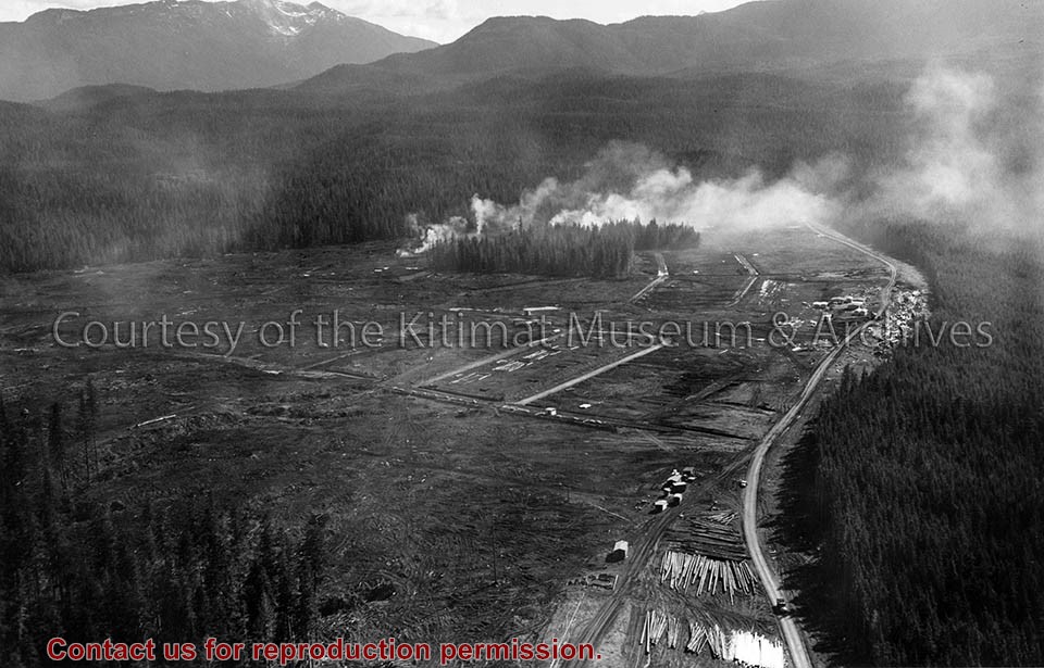
Photograph of aerial view of neighbourhood C. Note debris piles and logs in area C-II in the foreground. Kitlope, Kootney, Capilano, snd Babine streets visible with completed homes.
Land clearing of Kitimat. All aerials for development.
Custodial History
From the files of Ray Hunstone. Photos from an Alcan binder, have Alcan numbers.
Scope and Content
Photograph of aerial view of neighbourhood C. Note debris piles and logs in area C-II in the foreground. Kitlope, Kootney, Capilano, snd Babine streets visible with completed homes.