23 maps of northwestern British Columbia, from the Seven Sisters westward to Port Essington.
2018.9.1a-b – Seven Sisters / Dorreen
2018.9.2a-c – Usk / Chist Creek
2018.9.3a-c – Lakelse / Terrace
2018.9.4a-b – Alastair Lake
2018.9.5a-b – Salvus, Coast District Range 5
2018.9.6a-d – Ecstall River / Port Essington
2018.9.7a-g – Kitimat Arm, Kildala River, Mt. Aetna, Mount Elizabeth, Mount Davies, private logging roads
Maps were collected and annotated by Gisela Mendel throughout her time in northwest BC and donated to the Museum in 2018.
Scope and Content
23 maps of northwestern British Columbia, from the Seven Sisters westward to Port Essington.
2018.9.1a-b – Seven Sisters / Dorreen
2018.9.2a-c – Usk / Chist Creek
2018.9.3a-c – Lakelse / Terrace
2018.9.4a-b – Alastair Lake
2018.9.5a-b – Salvus, Coast District Range 5
2018.9.6a-d – Ecstall River / Port Essington
2018.9.7a-g – Kitimat Arm, Kildala River, Mt. Aetna, Mount Elizabeth, Mount Davies, private logging roads
Photograph of Aerial View of Kildala Neighborhood ; Nechako Neighborhood ; City Centre ; Haisla Bridge ; Kitimat River ; Riverlodge Camp ; Parks and Campgrounds ; Municipal ; Radley Park
Map of Kitimat, Coast District Range 5, Department of Lands and Forests, 1956-1957. Map shows early construction camps, Nechako neighbourhood, Reservations, all topography references.
Map of Kitimat, Coast District Range 5, Department of Lands and Forests, 1956-1957. Map shows early construction camps, Nechako neighbourhood, Reservations, all topography references.
Northern Sentinel: Box #4: (A) Historical (1) District of Kitimat (a) Town Planning (i) Mayer, Whittlesey and Glass, New York (ii) Resident Planning Engineer
Scope and Content
Photo showing (Municipal) map of area of the corporation of the District of Kitimat.
There is an apartment complex at the bottom left hand side of the photograph, with the United Church of Canada to the right of it. To the right of the church is Kingfisher Avenue.
There is an apartment complex at the bottom left hand side of the photograph, with the United Church of Canada to the right of it. To the right of the church is Kingfisher Avenue.
Photograph showing two women looking at a map. One of the women is wearing a scarf over her hair and a coat, the other woman is wearing a knit button up sweater. Both of them are wearing glasses. In the foreground of the women, there is a projector sitting on a table. Part of the Loggers Supplement 1972.
Photograph showing two women looking at a map. One of the women is wearing a scarf over her hair and a coat, the other woman is wearing a knit button up sweater. Both of them are wearing glasses. In the foreground of the women, there is a projector sitting on a table. Part of the Loggers Supplement 1972.
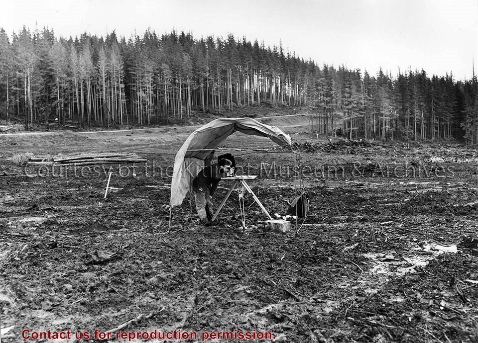
Slide showing dirt road leading to a bridge over a river/creek, possibly Anderson Creek. Grassy area on other side with white foundation structures for transmission line. Mountains in background. Mount Elizabeth partially visible on left side.
James McNay was born in Ayrshire, Scotland, on January 31, 1907. Between 1951 and 1953, he worked in the payroll department for Alcan. He had to leave his wife Effie and his two young daughters, Margaret and Diane, aged 6 and 5 in 1951, at home in Surrey, B.C., during his 3-4 month stints in Kitimat. To fill some of his free time and show his family where he was and what Kitimat was like, he spent many hours walking in the area with a 35mm Kodak camera. He photographed the scenic beauty of the area and parts of the construction of both the smelters and the town. He died in Surrey on August 7, 1983.
Custodial History
Donated by Margaret McNay. Images were taken by her father and sent to their family in Surrey in the 1950s.
Scope and Content
Slide showing dirt road leading to a bridge over a river/creek, possibly Anderson Creek. Grassy area on other side with white foundation structures for transmission line. Mountains in background. Mount Elizabeth partially visible on left side.
Photograph of the Duke of Edinburgh viewing the map of a new town in Canada familiar to him-Kitimat.
Notes
Picture above shows the Duke of Edinburgh viewing the map of a new town in Canada familiar to him- Kitimat. He opened the Aluminum Company of Canada, limited's smelter here on his tour of Canada in 1954. By Henry Strub, staff member of Aluminum Secretariat Limited of Montreal, who has been in Brussels in connection with Alcan's exhibit at the world's Fair.
One hand drawn map showing the the Sumgas Summer Village. Names of house residents are listed next to home marks. Map created by the Kitamaat Village Land Claims Office.
One hand drawn map showing the the Sumgas Summer Village. Names of house residents are listed next to home marks. Map created by the Kitamaat Village Land Claims Office.