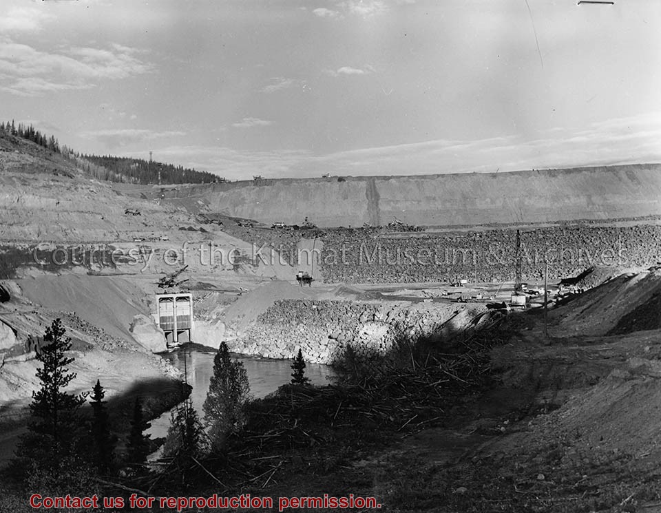
Photo of four men in suits. One man with his arm raised in greeting, a cigar in his other hand. They are standing on a railcar. Naming ceremony for Kenny Dam.
Left to right: The Honourable Edward T. Kenney, Liberal Minister of the Department of Lands and Forests for the Province of British Columbia, Ron Whyte's father William Alan Whyte, General Freight Agent (Western Division) for the Canadian National Railways and Steamships, Vancouver, BC; McNeely DuBose, Vice-President, Aluminum Company of Canada, Limited; and The Honourable Clarence Wallace, Lieutenant Governor of the Province of British Columbia.
Photograph of aerial photograph looking east toward neighbourhood A with the City Centre clearing in the right-hand foreground and neighbourhood A-IV clearing in the centre foreground.
Donated by Jackie Worboys. Given to the Jackie Mufford Worboys family by Wally Melville.
Scope and Content
Photograph of aerial photograph looking east toward neighbourhood A with the City Centre clearing in the right-hand foreground and neighbourhood A-IV clearing in the centre foreground.
Photograph of aerial looking south-east across neighbourhood A with neighbourhood A-II clearing in foreground and Minette Bay in the background. Nechako Centre and School are visible.
Donated by Jackie Worboys. Given to the Jackie Mufford Worboys family by Wally Melville.
Scope and Content
Photograph of aerial looking south-east across neighbourhood A with neighbourhood A-II clearing in foreground and Minette Bay in the background. Nechako Centre and School are visible.
Photograph of aerial view looking east across neighbourhood A-III and A-I. Note in upper left centre a portion of the concrete walks already constructed, which eventually will lead to Kingfisher underpass. Also note contrast between landscaped areas and those surrounding the houses now under construction. Gyrfaclon street in centre. Nechako Centre and School visible at upper left. Nechako school has protables outside.
Donated by Jackie Worboys. Given to the Jackie Mufford Worboys family by Wally Melville.
Scope and Content
Photograph of aerial view looking east across neighbourhood A-III and A-I. Note in upper left centre a portion of the concrete walks already constructed, which eventually will lead to Kingfisher underpass. Also note contrast between landscaped areas and those surrounding the houses now under construction. Gyrfaclon street in centre. Nechako Centre and School visible at upper left. Nechako school has protables outside.
Photograph of aerial view looking north-east across neighbourhood A-I with Petrel and Oriole Streets in the foreground. Nechako Centre and School visible behind.
Donated by Jackie Worboys. Given to the Jackie Mufford Worboys family by Wally Melville.
Scope and Content
Photograph of aerial view looking north-east across neighbourhood A-I with Petrel and Oriole Streets in the foreground. Nechako Centre and School visible behind.
Photograph of aerial view looking towards the west of the Kitimat Townsite with neighbourhood A-I in the foreground. City Centre clearing in background with slash burning smoke.
Donated by Jackie Worboys. Given to the Jackie Mufford Worboys family by Wally Melville.
Scope and Content
Photograph of aerial view looking towards the west of the Kitimat Townsite with neighbourhood A-I in the foreground. City Centre clearing in background with slash burning smoke.
Photograph of aerial view looking southeast across neighbourhood A-I towards Minette Bay. Note timber felled for the B-I High School site in the foreground.
Donated by Jackie Worboys. Given to the Jackie Mufford Worboys family by Wally Melville.
Scope and Content
Photograph of aerial view looking southeast across neighbourhood A-I towards Minette Bay. Note timber felled for the B-I High School site in the foreground.
Photograph of aerial photograph looking west across neighbourhood C. Logs in lower right-hand corner are now being removed. In the background is the Riverlodge camp, with the dyke behind it. On top towards the right, the Kitimat River bridge is just visible.
Donated by Jackie Worboys. Given to the Jackie Mufford Worboys family by Wally Melville.
Scope and Content
Photograph of aerial photograph looking west across neighbourhood C. Logs in lower right-hand corner are now being removed. In the background is the Riverlodge camp, with the dyke behind it. On top towards the right, the Kitimat River bridge is just visible.
Photograph of aerial view of neighbourhood C. Note debris piles and logs in area C-II in the foreground. Kitlope, Kootney, Capilano, snd Babine streets visible with completed homes.
Land clearing of Kitimat. All aerials for development.
Custodial History
From the files of Ray Hunstone. Photos from an Alcan binder, have Alcan numbers.
Scope and Content
Photograph of aerial view of neighbourhood C. Note debris piles and logs in area C-II in the foreground. Kitlope, Kootney, Capilano, snd Babine streets visible with completed homes.
Photograph of aerial view looking south-west across Teal and Swallow Streets towards the Nechako Centre School and commercial buildings in neighbourhood A-I. Many houses still under construction. Portables can be seen outside Nechako School.
Donated by Jackie Worboys. Given to the Jackie Mufford Worboys family by Wally Melville.
Scope and Content
Photograph of aerial view looking south-west across Teal and Swallow Streets towards the Nechako Centre School and commercial buildings in neighbourhood A-I. Many houses still under construction. Portables can be seen outside Nechako School.
Photograph of looking northeast across part of neighbourhood 'C' towards Kitimat river bridge. Burning taking place in clearing for Riverlodge development. Winter.
Land clearing of Kitimat. All aerials for development.
Custodial History
From the files of Ray Hunstone. Photos from an Alcan binder, have Alcan numbers.
Scope and Content
Photograph of looking northeast across part of neighbourhood 'C' towards Kitimat river bridge. Burning taking place in clearing for Riverlodge development. Winter.