Photograph of a cleared out area. Small house and logging truck on right. Another small house is a bit further back with two standing poles near it. Ground is wet.
Donated by Jackie Worboys. Given to the Jackie Mufford Worboys family by Wally Melville.
Scope and Content
Photograph of a cleared out area. Small house and logging truck on right. Another small house is a bit further back with two standing poles near it. Ground is wet.
Photograph of a logging truck in a cleared out area. Man is standing on the truck. Two standing poles visible behind truck. Two small buildings to the right with a sign on one reading "Mary's Inn." Ground is wet.
Donated by Jackie Worboys. Given to the Jackie Mufford Worboys family by Wally Melville.
Scope and Content
Photograph of a logging truck in a cleared out area. Man is standing on the truck. Two standing poles visible behind truck. Two small buildings to the right with a sign on one reading "Mary's Inn." Ground is wet.
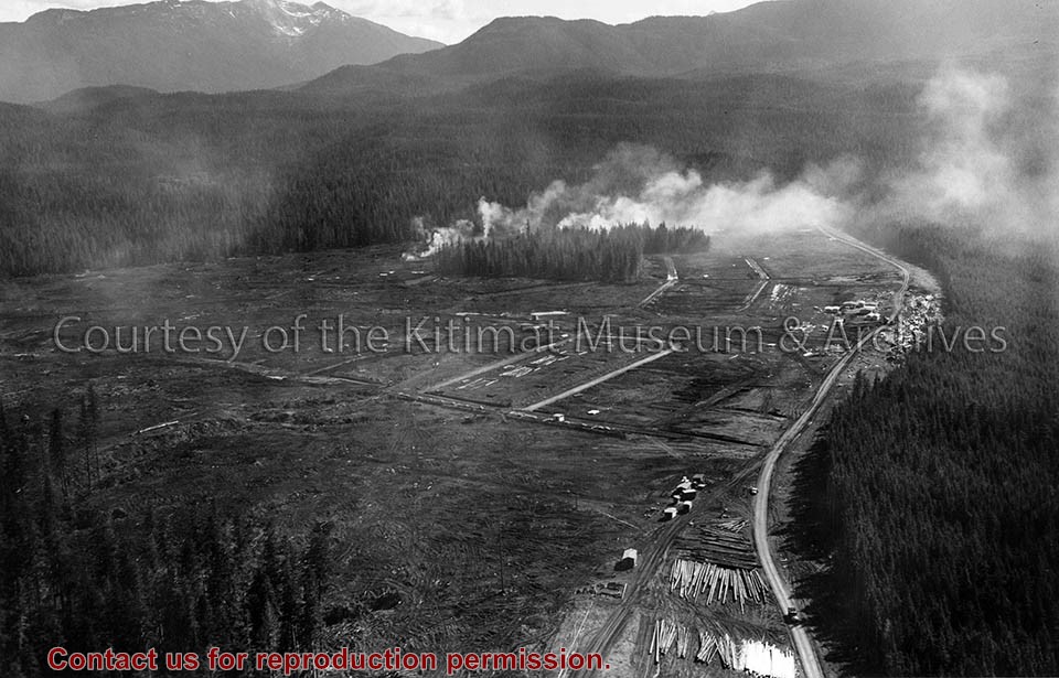
Photograph of the clearing operations north of Haisla boulevard. Falling operations in the hospital site. Smoke in middle and cars in the road to the right.
Land clearing of Kitimat. All aerials for development.
Custodial History
From the files of Ray Hunstone. Photos from an Alcan binder, have Alcan numbers.
Scope and Content
Photograph of the clearing operations north of Haisla boulevard. Falling operations in the hospital site. Smoke in middle and cars in the road to the right.
Photograph of aerial view looking west showing C-II clearing in lower left hand corner, low rental housing area and neighbourhood C-I in centre, and new camp site clearing left-centre. Camp is at Riverlodge site. Kitimat River bridge visible behind. Lots of snow on ground.
Donated by Jackie Worboys. Given to the Jackie Mufford Worboys family by Wally Melville.
Scope and Content
Photograph of aerial view looking west showing C-II clearing in lower left hand corner, low rental housing area and neighbourhood C-I in centre, and new camp site clearing left-centre. Camp is at Riverlodge site. Kitimat River bridge visible behind. Lots of snow on ground.
Photograph of aerial photograph taken from over townsite camp looking toward City Centre showing extent of clearing in C-I area. Haisla Blvd. can be seen on left-hand side of the picture. At bottom a single structure can be seen. Some snow is behind it. In the very back Douglas Channel is visible.
Donated by Jackie Worboys. Given to the Jackie Mufford Worboys family by Wally Melville.
Scope and Content
Photograph of aerial photograph taken from over townsite camp looking toward City Centre showing extent of clearing in C-I area. Haisla Blvd. can be seen on left-hand side of the picture. At bottom a single structure can be seen. Some snow is behind it. In the very back Douglas Channel is visible.
Photograph of land clearing operation in neighbourhood C-II. Sewer line under construction in foreground is part of extension to Sagimat temporary housing. Pipe segments in foreground.
Land clearing of Kitimat. All aerials for development.
Custodial History
From the files of Ray Hunstone. Photos from an Alcan binder, have Alcan numbers.
Scope and Content
Photograph of land clearing operation in neighbourhood C-II. Sewer line under construction in foreground is part of extension to Sagimat temporary housing. Pipe segments in foreground.
Photograph of clearing of site for machine shop and plant yard, Moore Creek, looking north. Wood and debris being burned in centre. Truck and other machinery in front of that.
Bud Powell is a longtime resident of Kitimat and former smeltersite resident. He worked for Alcan.
Custodial History
Donated by Bud Powell.
Scope and Content
Photograph of clearing of site for machine shop and plant yard, Moore Creek, looking north. Wood and debris being burned in centre. Truck and other machinery in front of that.
Photograph of clearing for machine shop site and storage yard, Moore Creek camp in background, looking east. Wood and debris being burned in centre. Truck parked in foreground.
Bud Powell is a longtime resident of Kitimat and former smeltersite resident. He worked for Alcan.
Custodial History
Donated by Bud Powell.
Scope and Content
Photograph of clearing for machine shop site and storage yard, Moore Creek camp in background, looking east. Wood and debris being burned in centre. Truck parked in foreground.
Photograph of gully crossing #2 showing the clearing contractor placing the dead and diseased trees at the base of the gully to stop any further earth slippage and improve the appearance of the area. Houses visble on hill behind.
Land clearing of Kitimat. All aerials for development.
Custodial History
From the files of Ray Hunstone. Photos from an Alcan binder, have Alcan numbers.
Scope and Content
Photograph of gully crossing #2 showing the clearing contractor placing the dead and diseased trees at the base of the gully to stop any further earth slippage and improve the appearance of the area. Houses visble on hill behind.
Photograph of looking scross the north east corner of neighbourhood C-1 towards the City Centre. Note the temporary decked logs in the foreground and the permanently decked logs along the edge of the City Centre. Man and machine visible on far right.
Donated by Jackie Worboys. Given to the Jackie Mufford Worboys family by Wally Melville.
Scope and Content
Photograph of looking scross the north east corner of neighbourhood C-1 towards the City Centre. Note the temporary decked logs in the foreground and the permanently decked logs along the edge of the City Centre. Man and machine visible on far right.
Photograph of aerial looking south-east across neighbourhood A with neighbourhood A-II clearing in foreground and Minette Bay in the background. Nechako Centre and School are visible.
Donated by Jackie Worboys. Given to the Jackie Mufford Worboys family by Wally Melville.
Scope and Content
Photograph of aerial looking south-east across neighbourhood A with neighbourhood A-II clearing in foreground and Minette Bay in the background. Nechako Centre and School are visible.
Photograph of result of first clearing shown in BC-2-142. Note size of trees and condition of logs. Trees are cut/knocked down. Other trees still standing behind.
Bud Powell is a longtime resident of Kitimat and former smeltersite resident. He worked for Alcan.
Custodial History
Donated by Bud Powell.
Scope and Content
Photograph of result of first clearing shown in BC-2-142. Note size of trees and condition of logs. Trees are cut/knocked down. Other trees still standing behind.
Photograph of view looking north-east over initial area cleared for smelter service building construction. Light area has been gravel filled, dark area overburden to be stripped. Trucks and machinery visible at work.
Bud Powell is a longtime resident of Kitimat and former smeltersite resident. He worked for Alcan.
Custodial History
Donated by Bud Powell.
Scope and Content
Photograph of view looking north-east over initial area cleared for smelter service building construction. Light area has been gravel filled, dark area overburden to be stripped. Trucks and machinery visible at work.
Photograph of cleared helicopter landing space on top of Iron Mountain. Kim Creed is standing there next to an oil drum. He has no shirt on. He is 20 years old.
Photos from Kim Creed from the Iron Mountain mine sites. Kim worked at the mine. The photo collection shows the diamond driller that helped to drill out thousands of feet of drill core back in the early 1960s.
Custodial History
These photos belonged to Kim Creed. They were given to Walter Thorne who donated them to the museum.
Scope and Content
Photograph of cleared helicopter landing space on top of Iron Mountain. Kim Creed is standing there next to an oil drum. He has no shirt on. He is 20 years old.