Black covered book titled "Kitimat Townsite Report". No. A-33 Mr. J.E. Dudley. Contains info about early Kitimat and planning. Inside front cover are some loose pages with town plans.
Bud Powell is a longtime resident of Kitimat and former smeltersite resident. He worked for Alcan.
Custodial History
Donated by Bud Powell.
Scope and Content
Black covered book titled "Kitimat Townsite Report". No. A-33 Mr. J.E. Dudley. Contains info about early Kitimat and planning. Inside front cover are some loose pages with town plans.
Photograph of view looking north, showing south approach to Moore Creek highway bridge at left. Vehicles on road and parked around. Buildings at right.
Bud Powell is a longtime resident of Kitimat and former smeltersite resident. He worked for Alcan.
Custodial History
Donated by Bud Powell.
Scope and Content
Photograph of view looking north, showing south approach to Moore Creek highway bridge at left. Vehicles on road and parked around. Buildings at right.
Photograph of aerial picture looking south-east across Kitimat Townsite showing falling in neighbourhood B-IV in the foreground and Minette Bay in the background.
Donated by Jackie Worboys. Given to the Jackie Mufford Worboys family by Wally Melville.
Scope and Content
Photograph of aerial picture looking south-east across Kitimat Townsite showing falling in neighbourhood B-IV in the foreground and Minette Bay in the background.
Photograph of aerial view looking towards the west of the Kitimat Townsite with neighbourhood A-I in the foreground. City Centre clearing in background with slash burning smoke.
Donated by Jackie Worboys. Given to the Jackie Mufford Worboys family by Wally Melville.
Scope and Content
Photograph of aerial view looking towards the west of the Kitimat Townsite with neighbourhood A-I in the foreground. City Centre clearing in background with slash burning smoke.
Photograph of aerial view looking northwest showing Moore Creek highway bridge and paved approaches. New Moore Creek bridge site at lower right. Moore Creek Falls visible. Various smeltersite buildings in foreground.
Bud Powell is a longtime resident of Kitimat and former smeltersite resident. He worked for Alcan.
Custodial History
Donated by Bud Powell.
Scope and Content
Photograph of aerial view looking northwest showing Moore Creek highway bridge and paved approaches. New Moore Creek bridge site at lower right. Moore Creek Falls visible. Various smeltersite buildings in foreground.
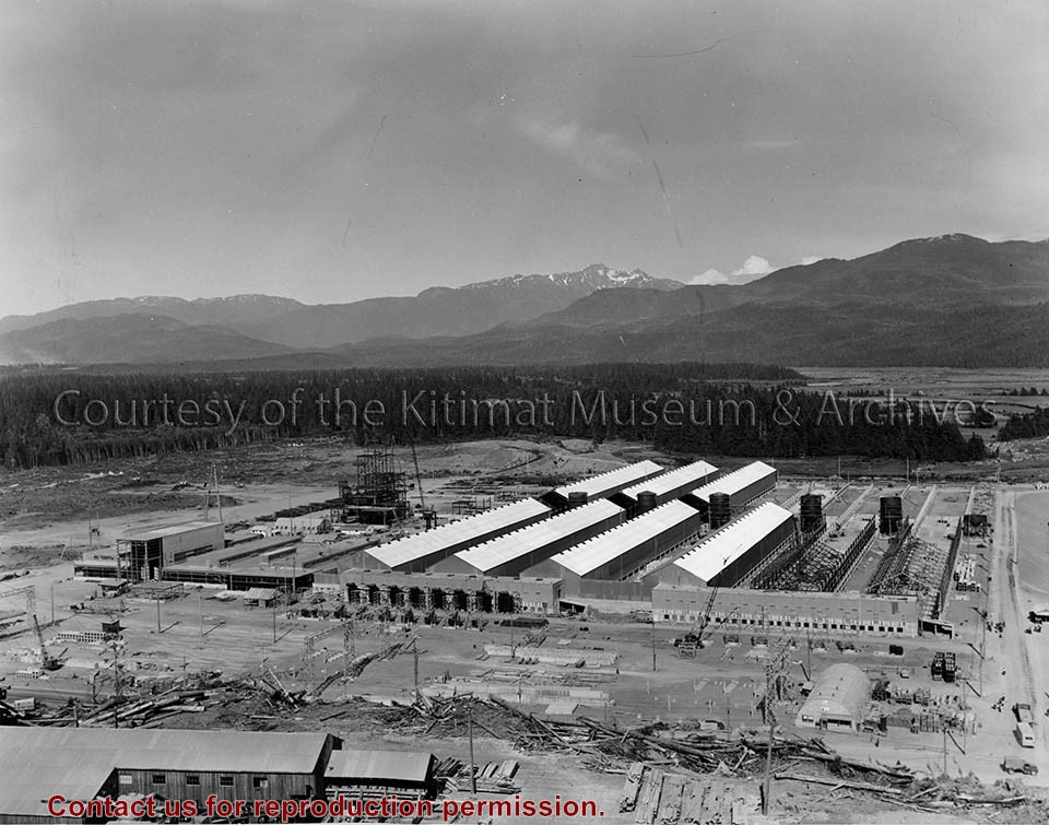
Photograph of view looking east showing progress of potline 2, alumina storage bins and sub-station 2. Area under construction, construction material in foreground.
Bud Powell is a longtime resident of Kitimat and former smeltersite resident. He worked for Alcan.
Custodial History
Donated by Bud Powell.
Scope and Content
Photograph of view looking east showing progress of potline 2, alumina storage bins and sub-station 2. Area under construction, construction material in foreground.
Photograph of showing the framing almost completed in Guest House No.2. Two men are visible working on it. Apartments visible behind, and townsite camp is to the left.
Donated by Jackie Worboys. Given to the Jackie Mufford Worboys family by Wally Melville.
Scope and Content
Photograph of showing the framing almost completed in Guest House No.2. Two men are visible working on it. Apartments visible behind, and townsite camp is to the left.
Photograph of completed paving on road between east passageway of potline 7 and Moore Creek railway bridge. Shoulder grading was later completed. Machinery and vehicles working. Powerlines on left side.
Bud Powell is a longtime resident of Kitimat and former smeltersite resident. He worked for Alcan.
Custodial History
Donated by Bud Powell.
Scope and Content
Photograph of completed paving on road between east passageway of potline 7 and Moore Creek railway bridge. Shoulder grading was later completed. Machinery and vehicles working. Powerlines on left side.
Photograph of gully crossing #2 showing the clearing contractor placing the dead and diseased trees at the base of the gully to stop any further earth slippage and improve the appearance of the area. Houses visble on hill behind.
Land clearing of Kitimat. All aerials for development.
Custodial History
From the files of Ray Hunstone. Photos from an Alcan binder, have Alcan numbers.
Scope and Content
Photograph of gully crossing #2 showing the clearing contractor placing the dead and diseased trees at the base of the gully to stop any further earth slippage and improve the appearance of the area. Houses visble on hill behind.