Map, of the District Municipality of Kitimat, British Columbia, drawn by G.V. Laurenson, May 1955 for Hudson's Bay Company. 1st. Edition.Map includes Neighborhood 'A' or 'Nechako', Kitimat Service Center, Aluminum Company of Canada Ltd.'s B.C. Project, Nechako Center, Kitimat City Center and a Reference section.
Map, of the District Municipality of Kitimat, British Columbia, drawn by G.V. Laurenson, May 1955 for Hudson's Bay Company. 1st. Edition.Map includes Neighborhood 'A' or 'Nechako', Kitimat Service Center, Aluminum Company of Canada Ltd.'s B.C. Project, Nechako Center, Kitimat City Center and a Reference section.
Photograph of pre-cast concrete yard looking north-west from rectifier building #102. Many men and work. Lots of buildings visible behind. A little bit of snow on the slope behind buildings.
Bud Powell is a longtime resident of Kitimat and former smeltersite resident. He worked for Alcan.
Custodial History
Donated by Bud Powell.
Scope and Content
Photograph of pre-cast concrete yard looking north-west from rectifier building #102. Many men and work. Lots of buildings visible behind. A little bit of snow on the slope behind buildings.
Photograph of "I really would like to have what he's playing with." The little fellow standing seems to be contemplating the idea of either fighting or snitching with the tot in front. The occasion was pre-school registration at Riverlodge Wednesday and many of the little people gathered in the playroom for a bit of social interaction while waiting for their turns to register.
Photograph of "I really would like to have what he's playing with." The little fellow standing seems to be contemplating the idea of either fighting or snitching with the tot in front. The occasion was pre-school registration at Riverlodge Wednesday and many of the little people gathered in the playroom for a bit of social interaction while waiting for their turns to register.
Photograph of Aerial View of Kildala Neighborhood ; Nechako Neighborhood ; City Centre ; Haisla Bridge ; Kitimat River ; Riverlodge Camp ; Parks and Campgrounds ; Municipal ; Radley Park
Map of Kitimat, Coast District Range 5, Department of Lands and Forests, 1956-1957. Map shows early construction camps, Nechako neighbourhood, Reservations, all topography references.
Map of Kitimat, Coast District Range 5, Department of Lands and Forests, 1956-1957. Map shows early construction camps, Nechako neighbourhood, Reservations, all topography references.
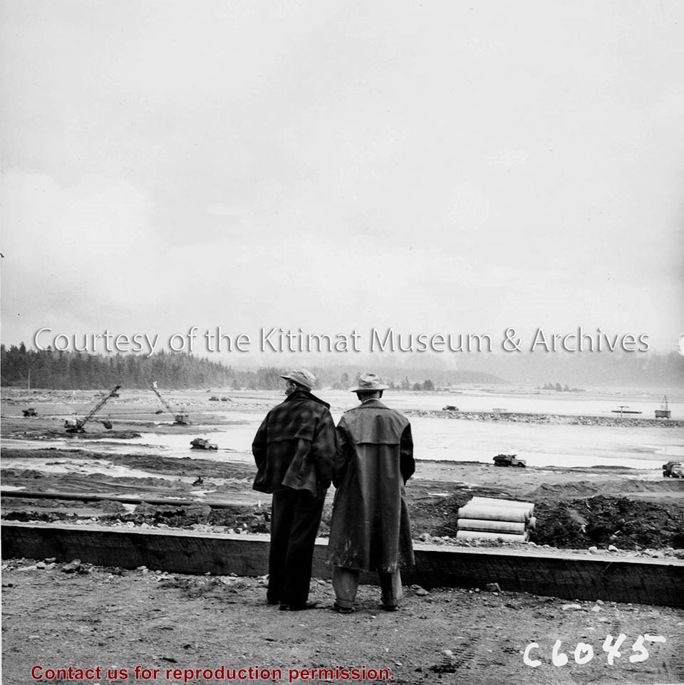
Photo depicts Kitimat Constructors Project Manager Hal Whiting on right, standing beside a unidentified man. Both watch the construction activity occurring down on the tidal flats in front of them, site for the smelter.
Photo depicts Kitimat Constructors Project Manager Hal Whiting on right, standing beside a unidentified man. Both watch the construction activity occurring down on the tidal flats in front of them, site for the smelter.
Notes
Title based on content of photograph. -- Photographed by the International Harvester Company, manufacturers of construction equipment purchased for the Project. Hal Whiting Collection 985.65.99
Photograph of pre-cast air duct partition walls, background buildings left to right, contractor's administrative office, machine shop, truck repair shop, Alcan concrete control laboratory.
Bud Powell is a longtime resident of Kitimat and former smeltersite resident. He worked for Alcan.
Custodial History
Donated by Bud Powell.
Scope and Content
Photograph of pre-cast air duct partition walls, background buildings left to right, contractor's administrative office, machine shop, truck repair shop, Alcan concrete control laboratory.