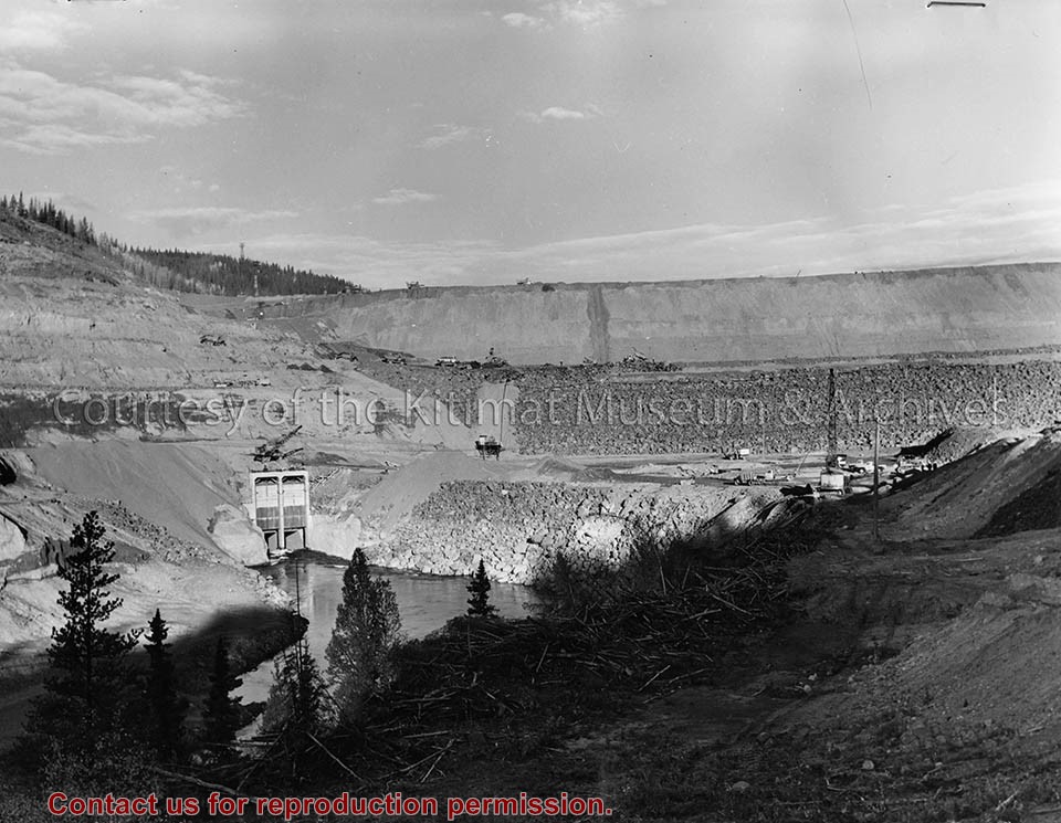
Photograph of aerial view of City Centre and neighbourhood C-I. Please note stripping in progress in City Centre. Douglas Channel visible in background. There is an arrow pointing to the lower right side with a note saying "fire was in this felled area shown here. Got partly into the standing timber also."
Donated by Jackie Worboys. Given to the Jackie Mufford Worboys family by Wally Melville.
Scope and Content
Photograph of aerial view of City Centre and neighbourhood C-I. Please note stripping in progress in City Centre. Douglas Channel visible in background. There is an arrow pointing to the lower right side with a note saying "fire was in this felled area shown here. Got partly into the standing timber also."
Photograph of aerial view looking towards the west of the Kitimat Townsite with neighbourhood A-I in the foreground. City Centre clearing in background with slash burning smoke.
Donated by Jackie Worboys. Given to the Jackie Mufford Worboys family by Wally Melville.
Scope and Content
Photograph of aerial view looking towards the west of the Kitimat Townsite with neighbourhood A-I in the foreground. City Centre clearing in background with slash burning smoke.
Photograph of aerial view looking southeast across neighbourhood A-I towards Minette Bay. Note timber felled for the B-I High School site in the foreground.
Donated by Jackie Worboys. Given to the Jackie Mufford Worboys family by Wally Melville.
Scope and Content
Photograph of aerial view looking southeast across neighbourhood A-I towards Minette Bay. Note timber felled for the B-I High School site in the foreground.
Photograph of aerial of Starling, Swallow, and Teal Streets. Please note the floor slabs poured and houses under construction by N.W. Hullah Construction Limited.
Donated by Jackie Worboys. Given to the Jackie Mufford Worboys family by Wally Melville.
Scope and Content
Photograph of aerial of Starling, Swallow, and Teal Streets. Please note the floor slabs poured and houses under construction by N.W. Hullah Construction Limited.
Photograph of aerial of Starling, Swallow, and Teal Streets. Please note the floor slabs poured and houses under construction by N.W. Hullah Construction Limited.
Donated by Jackie Worboys. Given to the Jackie Mufford Worboys family by Wally Melville.
Scope and Content
Photograph of aerial of Starling, Swallow, and Teal Streets. Please note the floor slabs poured and houses under construction by N.W. Hullah Construction Limited.
Photograph of aerial view of neighbourhood C. Note debris piles and logs in area C-II in the foreground. Kitlope, Kootney, Capilano, snd Babine streets visible with completed homes.
Land clearing of Kitimat. All aerials for development.
Custodial History
From the files of Ray Hunstone. Photos from an Alcan binder, have Alcan numbers.
Scope and Content
Photograph of aerial view of neighbourhood C. Note debris piles and logs in area C-II in the foreground. Kitlope, Kootney, Capilano, snd Babine streets visible with completed homes.
Photograph of aerial view looking north-west across the east of neighbourhood A showing house construction on Wren, Teal and Swallow streets. Many houses still are only foundations. Streets further back are more complete.
Donated by Jackie Worboys. Given to the Jackie Mufford Worboys family by Wally Melville.
Scope and Content
Photograph of aerial view looking north-west across the east of neighbourhood A showing house construction on Wren, Teal and Swallow streets. Many houses still are only foundations. Streets further back are more complete.
Photograph of aerial photograph looking west across neighbourhood C. Logs in lower right-hand corner are now being removed. In the background is the Riverlodge camp, with the dyke behind it. On top towards the right, the Kitimat River bridge is just visible.
Donated by Jackie Worboys. Given to the Jackie Mufford Worboys family by Wally Melville.
Scope and Content
Photograph of aerial photograph looking west across neighbourhood C. Logs in lower right-hand corner are now being removed. In the background is the Riverlodge camp, with the dyke behind it. On top towards the right, the Kitimat River bridge is just visible.
Photograph of aerial view looking west showing C-II clearing in lower left hand corner, low rental housing area and neighbourhood C-I in centre, and new camp site clearing left-centre. Camp is at Riverlodge site. Kitimat River bridge visible behind. Lots of snow on ground.
Donated by Jackie Worboys. Given to the Jackie Mufford Worboys family by Wally Melville.
Scope and Content
Photograph of aerial view looking west showing C-II clearing in lower left hand corner, low rental housing area and neighbourhood C-I in centre, and new camp site clearing left-centre. Camp is at Riverlodge site. Kitimat River bridge visible behind. Lots of snow on ground.
Photograph of aerial picture looking south-east across Kitimat Townsite showing falling in neighbourhood B-IV in the foreground and Minette Bay in the background.
Donated by Jackie Worboys. Given to the Jackie Mufford Worboys family by Wally Melville.
Scope and Content
Photograph of aerial picture looking south-east across Kitimat Townsite showing falling in neighbourhood B-IV in the foreground and Minette Bay in the background.
Photograph of aerial view of west end of neighbourhood C-I and motel site A. Please note temporary housing units in left centre of photograph. Clearing shown in lower left corner is that for neighbourhood C Dyke.
Donated by Jackie Worboys. Given to the Jackie Mufford Worboys family by Wally Melville.
Scope and Content
Photograph of aerial view of west end of neighbourhood C-I and motel site A. Please note temporary housing units in left centre of photograph. Clearing shown in lower left corner is that for neighbourhood C Dyke.