Photocopied documents relating to John McLachlan's employment with Alcan.
1) Letter of employment, G. W. Whitehead (Alcan) to John McLachlan, offering position as Draughtsman in Kitimat. April 10th 1953
2) Letter of acceptance, John McLachlan to G.W. Whitehead. April 11th 1953
3) Alcan Personnel Department introduction form, to Mr. G. T. Malby, Resident Engineer, May 13th 1953
4) Invitation to join Retirement Income and Life Insurance Plan, Ian Maclean to John McLachlan, June 23rd 1954.
5) Account of duties as Senior Draughtsman, John McLachlan to W. H. Sparks, September 11th 1956.
John McLachlan arrived in Kitimat in 1953 as a 23-year-old immigrant and went on to work at Alcan's Property Engineering Department for almost 40 years. He started out as a land surveyor and cartographer in the town's early years and ended his career as a Senior Legal Draftsmen.
Custodial History
Donated by Jean Lunny, January 12th 2018
Scope and Content
Photocopied documents relating to John McLachlan's employment with Alcan.
1) Letter of employment, G. W. Whitehead (Alcan) to John McLachlan, offering position as Draughtsman in Kitimat. April 10th 1953
2) Letter of acceptance, John McLachlan to G.W. Whitehead. April 11th 1953
3) Alcan Personnel Department introduction form, to Mr. G. T. Malby, Resident Engineer, May 13th 1953
4) Invitation to join Retirement Income and Life Insurance Plan, Ian Maclean to John McLachlan, June 23rd 1954.
5) Account of duties as Senior Draughtsman, John McLachlan to W. H. Sparks, September 11th 1956.
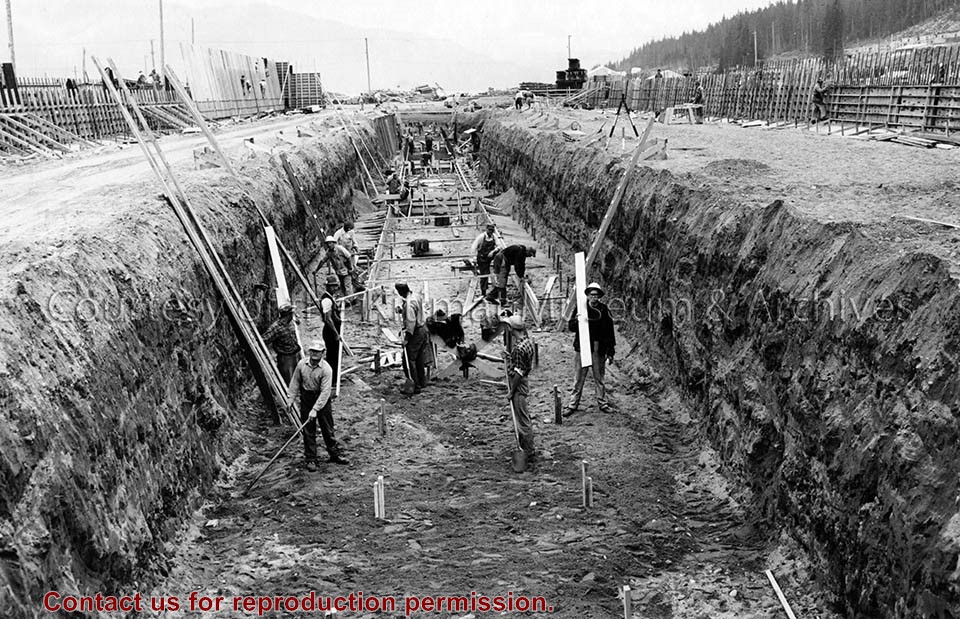
Photo depicts workers excavating for the construction of the alumina storage building.
Notes
Title based on content of photograph. -- Alcan ID No. BC-2-451. -- Sloping sides avoided cave-ins. -- Hal Whiting was Project Manager, Kitimat Constructors, for smelter and town construction. Hal Whiting Collection 985.65.267
Photograph of aerial photograph looking east toward neighbourhood A with the City Centre clearing in the right-hand foreground and neighbourhood A-IV clearing in the centre foreground.
Donated by Jackie Worboys. Given to the Jackie Mufford Worboys family by Wally Melville.
Scope and Content
Photograph of aerial photograph looking east toward neighbourhood A with the City Centre clearing in the right-hand foreground and neighbourhood A-IV clearing in the centre foreground.
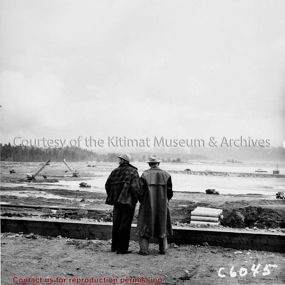
Photo depicts Kitimat Constructors Project Manager Hal Whiting on right, standing beside a unidentified man. Both watch the construction activity occurring down on the tidal flats in front of them, site for the smelter.
Photo depicts Kitimat Constructors Project Manager Hal Whiting on right, standing beside a unidentified man. Both watch the construction activity occurring down on the tidal flats in front of them, site for the smelter.
Notes
Title based on content of photograph. -- Photographed by the International Harvester Company, manufacturers of construction equipment purchased for the Project. Hal Whiting Collection 985.65.99
Photograph of aerial view looking east across neighbourhood A-III and A-I. Note in upper left centre a portion of the concrete walks already constructed, which eventually will lead to Kingfisher underpass. Also note contrast between landscaped areas and those surrounding the houses now under construction. Gyrfaclon street in centre. Nechako Centre and School visible at upper left. Nechako school has protables outside.
Donated by Jackie Worboys. Given to the Jackie Mufford Worboys family by Wally Melville.
Scope and Content
Photograph of aerial view looking east across neighbourhood A-III and A-I. Note in upper left centre a portion of the concrete walks already constructed, which eventually will lead to Kingfisher underpass. Also note contrast between landscaped areas and those surrounding the houses now under construction. Gyrfaclon street in centre. Nechako Centre and School visible at upper left. Nechako school has protables outside.
Photograph of looking west toward site of laboratory bldg. 273. Area clearcut. Cars on road on background. Powerlines along road. Something red is circled on the picture. Coordinate stake?
Bud Powell is a longtime resident of Kitimat and former smeltersite resident. He worked for Alcan.
Custodial History
Donated by Bud Powell.
Scope and Content
Photograph of looking west toward site of laboratory bldg. 273. Area clearcut. Cars on road on background. Powerlines along road. Something red is circled on the picture. Coordinate stake?
Photograph of aerial looking south-east across neighbourhood A with neighbourhood A-II clearing in foreground and Minette Bay in the background. Nechako Centre and School are visible.
Donated by Jackie Worboys. Given to the Jackie Mufford Worboys family by Wally Melville.
Scope and Content
Photograph of aerial looking south-east across neighbourhood A with neighbourhood A-II clearing in foreground and Minette Bay in the background. Nechako Centre and School are visible.
Photograph of looking east across neighbourhoods B-II, B-III and B-I. Piling operations in centre are complete. Completed Nechako neighbourhood and school visible on top right.
Land clearing of Kitimat. All aerials for development.
Custodial History
From the files of Ray Hunstone. Photos from an Alcan binder, have Alcan numbers.
Scope and Content
Photograph of looking east across neighbourhoods B-II, B-III and B-I. Piling operations in centre are complete. Completed Nechako neighbourhood and school visible on top right.
Photograph of sawmill and burner, looking north-east towards smelter and town sites. Logs piled up on left side. Tree in foreground growing out of centre of round, metal barrier.
Bud Powell is a longtime resident of Kitimat and former smeltersite resident. He worked for Alcan.
Custodial History
Donated by Bud Powell.
Scope and Content
Photograph of sawmill and burner, looking north-east towards smelter and town sites. Logs piled up on left side. Tree in foreground growing out of centre of round, metal barrier.
Photograph of looking northeast across part of neighbourhood 'C' towards Kitimat river bridge. Burning taking place in clearing for Riverlodge development. Winter.
Land clearing of Kitimat. All aerials for development.
Custodial History
From the files of Ray Hunstone. Photos from an Alcan binder, have Alcan numbers.
Scope and Content
Photograph of looking northeast across part of neighbourhood 'C' towards Kitimat river bridge. Burning taking place in clearing for Riverlodge development. Winter.
Photograph of looking north at coke calcining plant showing unloading hopper at left and concrete being placed at pier No.1. Cranes visible working. Lots of snow.
Bud Powell is a longtime resident of Kitimat and former smeltersite resident. He worked for Alcan.
Custodial History
Donated by Bud Powell.
Scope and Content
Photograph of looking north at coke calcining plant showing unloading hopper at left and concrete being placed at pier No.1. Cranes visible working. Lots of snow.
Photograph of aerial view looking west toward potline group B. Note sewer installed on cast side of terminal railway opposite potroom 8B. Storage area in foreground.
Bud Powell is a longtime resident of Kitimat and former smeltersite resident. He worked for Alcan.
Custodial History
Donated by Bud Powell.
Scope and Content
Photograph of aerial view looking west toward potline group B. Note sewer installed on cast side of terminal railway opposite potroom 8B. Storage area in foreground.
Photograph of aerial view looking west along Anderson Creek. Note very low flow in creek. Precast yard at left and construction shops at right. At centre is bridge across creek.
Bud Powell is a longtime resident of Kitimat and former smeltersite resident. He worked for Alcan.
Custodial History
Donated by Bud Powell.
Scope and Content
Photograph of aerial view looking west along Anderson Creek. Note very low flow in creek. Precast yard at left and construction shops at right. At centre is bridge across creek.