Photo depicts an aerial view of a portion of the Nechako neighbourhood showing the Hullah prototype area, Pintail and Partridge streets, in the foreground.
Photo depicts an aerial view of a portion of the Nechako neighbourhood showing the Hullah prototype area, Pintail and Partridge streets, in the foreground.
Notes
Title based on content of photograph. District of Kitimat Collection
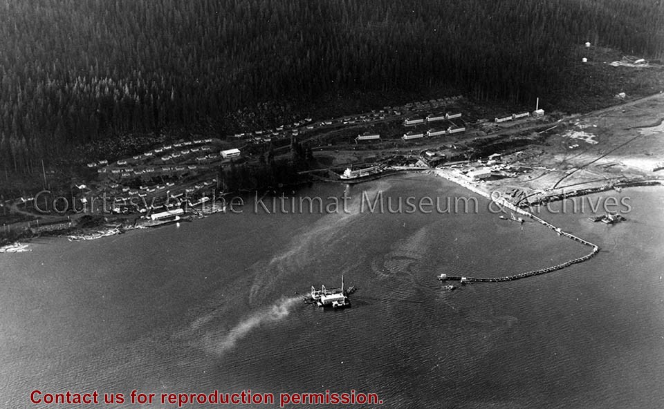
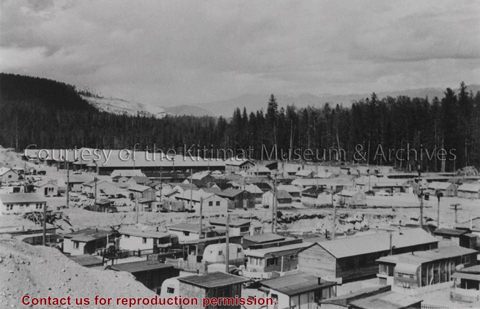
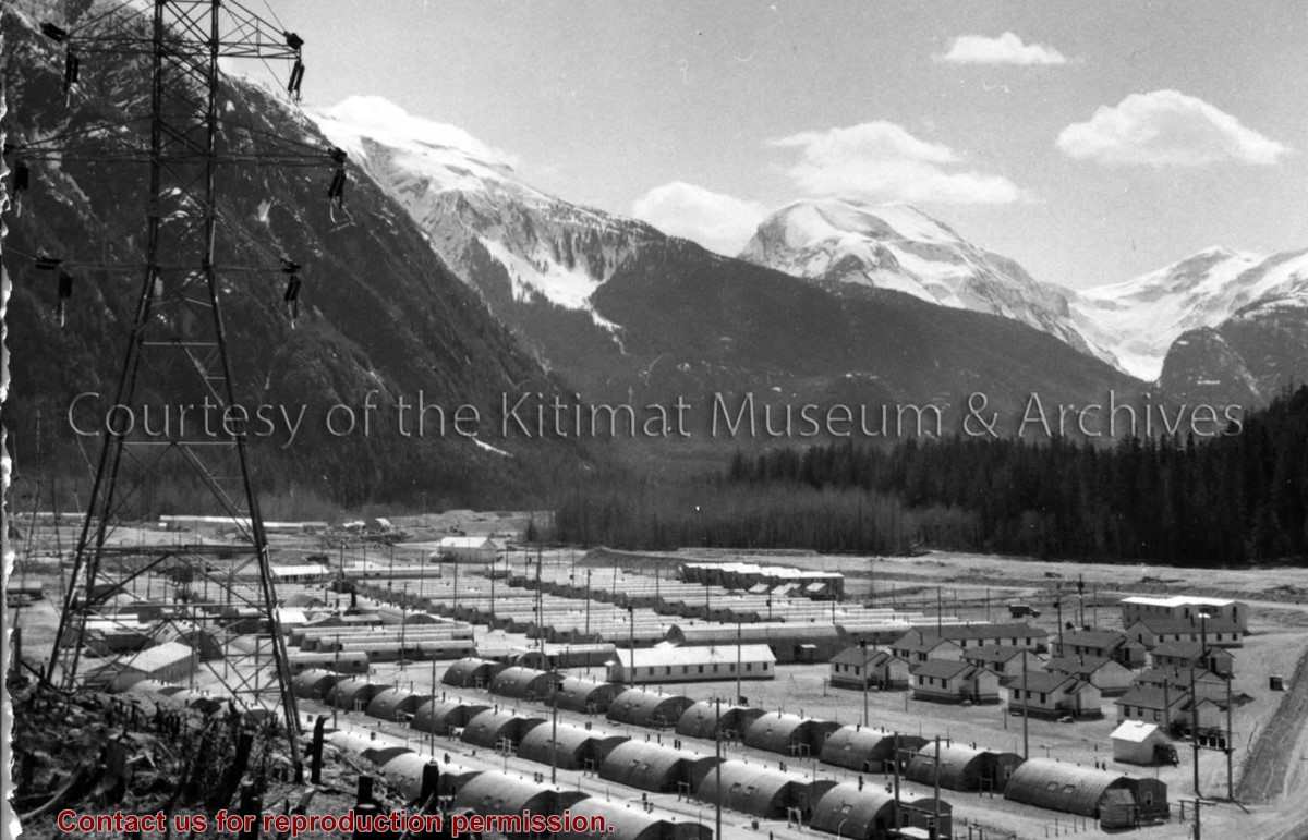
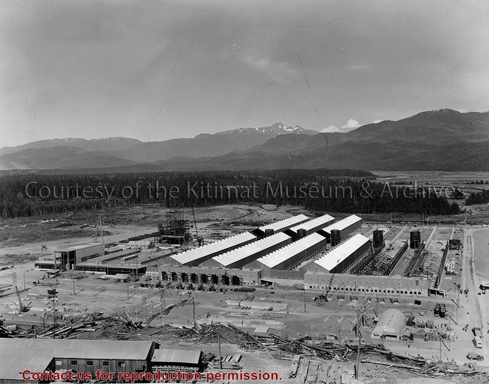
Photo depicts an aerial view of the smeltersite main camp showing married quarters, sternwheeler Delta King, hydraulic fill in progress, recreation building, hospital, power plant, sawmill and water tank.
Photo depicts an aerial view of the smeltersite main camp showing married quarters, sternwheeler Delta King, hydraulic fill in progress, recreation building, hospital, power plant, sawmill and water tank.
Notes
Title based on content of photograph. -- Alcan ID Numbers BC-2-243 and ACM-24311. Alcan Collection 78.11.32
Aerial view of the Kitimat River Bridge site looking south showing falsework for steel erection. The building at lower left is the Club House of the Kitimat Rod and Gun Club.
Aerial view of the Kitimat River Bridge site looking south showing falsework for steel erection. The building at lower left is the Club House of the Kitimat Rod and Gun Club.
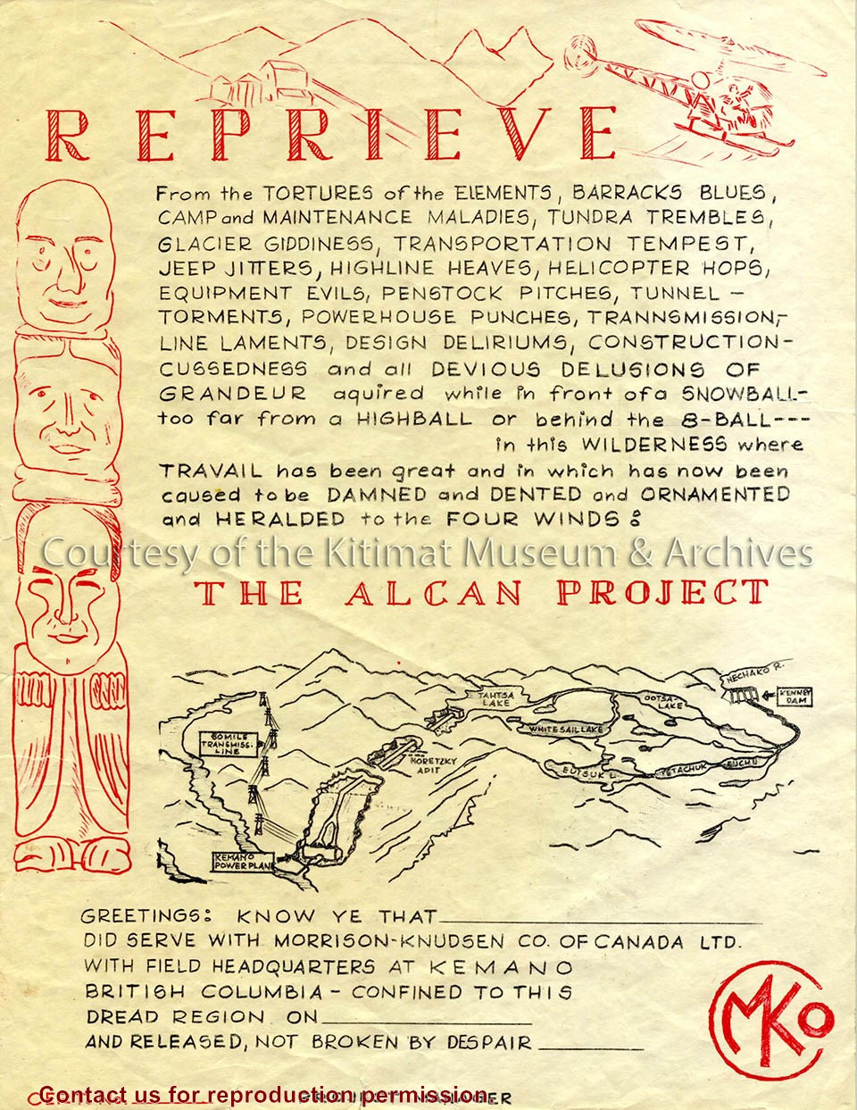
Image depicts a humorous reprieve certificate given to employees of the Alcan Project. The content also implies the hardships endured by the Morrison-Knudsen Company workers in Kemano.
Image depicts a humorous reprieve certificate given to employees of the Alcan Project. The content also implies the hardships endured by the Morrison-Knudsen Company workers in Kemano.
Notes
Title based on contents of text. Ernie Archer Collection
Photo depicts buildings at Anderson Hill Camp. Trailers and wash houses are in the foreground. The men's bunkhouses of Anderson Creek Camp are in the background.
Photo depicts buildings at Anderson Hill Camp. Trailers and wash houses are in the foreground. The men's bunkhouses of Anderson Creek Camp are in the background.
Notes
Title based on content of photograph. John Manders Collection
Base map of statistical area 6. The map shows Kitimat and surrounding coastal area. This map is a partial reproduction of the West Central British Columbia Base Map by Geographic Division, Surveys & Mapping Branch, Department of Lands, Forests, & Water Resources, Victoria, B.C. 1955-56.
Base map of statistical area 6. The map shows Kitimat and surrounding coastal area. This map is a partial reproduction of the West Central British Columbia Base Map by Geographic Division, Surveys & Mapping Branch, Department of Lands, Forests, & Water Resources, Victoria, B.C. 1955-56.
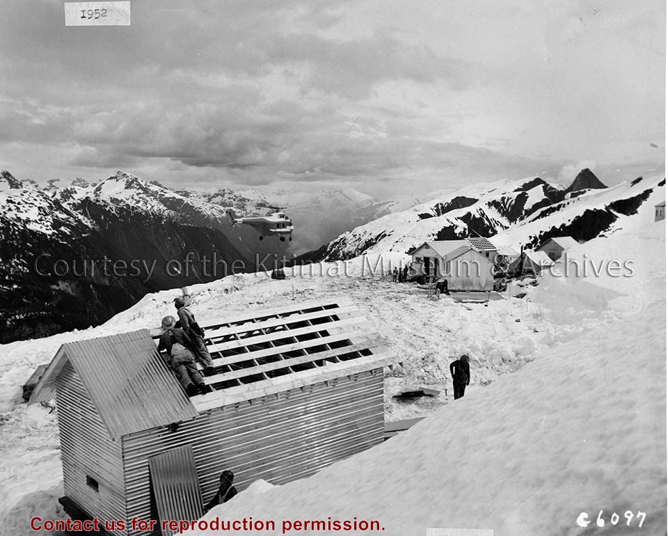
Photo depicts two workers looking on as a Sikorsky S-55 helicopter brings in a load of supplies to the transmission line camp atop Kildala Pass.
Notes
Photographed by the International Harverster Company, manufacturers of construction equipment purchased for the Project. Hal Whiting Collection 985.65.82
Photograph showing the kitimat river during winter. A D8 CAT bulldozer can be seen crossing the river with a man in a rowboat alongside. The photo is looking east toward townsite road clearing.
Photograph showing the kitimat river during winter. A D8 CAT bulldozer can be seen crossing the river with a man in a rowboat alongside. The photo is looking east toward townsite road clearing.
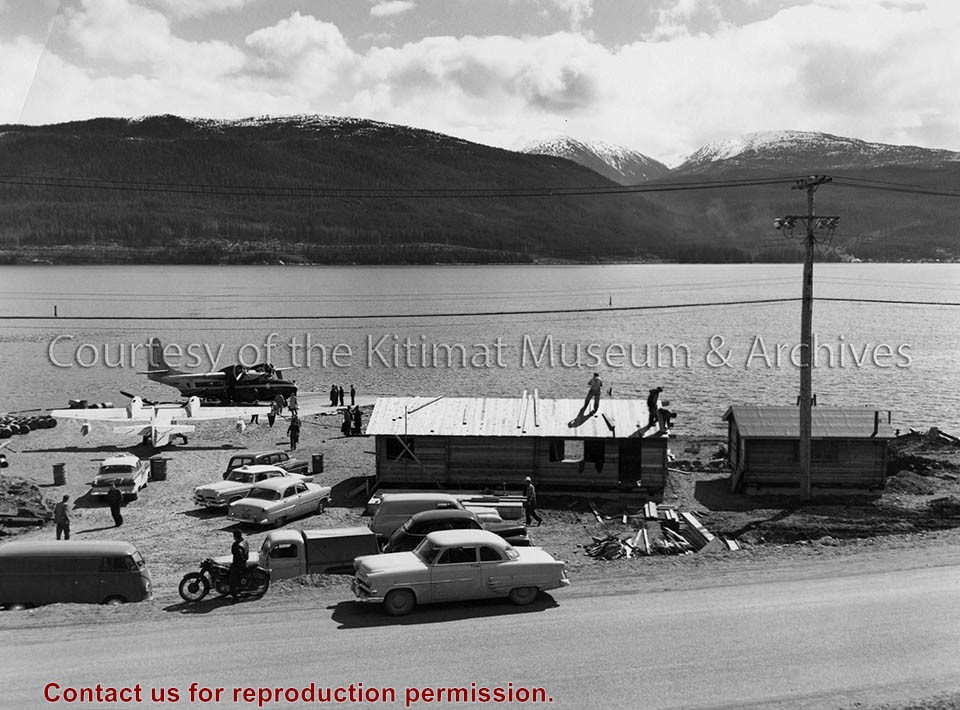
Photo depicts construction of two pan-abode waiting rooms on the beach at Smeltersite for Pacific Western Airlines. A "Mallard" amphibian airplane unloads on the landing ramp in the background.
Photo depicts construction of two pan-abode waiting rooms on the beach at Smeltersite for Pacific Western Airlines. A "Mallard" amphibian airplane unloads on the landing ramp in the background.
Notes
Pan-Abode is interlocking red cedar building materials invented in 1948 in British Columbia. The builders of Kitimat chose innovative materials such as Pan-Abode for the town. Pan-Abode was used in some of the first prototype homes on Kitimat's first streets - Oriole, Pintail, and Partridge. It is also an efficient building material as a structure can be assembled very quickly. Northern Sentinel Press Collection. P00226.jpg
Subdivision plan of part of district lots 6038, 6039 and part of block 29, plan 3435 range 5, Coast District. District Municipality of Kitimat. Plan 4228. November 5, 1961.
Plan of subdivision of parts of D.L. 6046 & west half of D.L. 6045, and parcel. "X" (former block 78 and adjoining road plan 3549) range 5, Coast District. District Municipality of Kitimat. Plan 4639. August 27, 1963.
Plan of portions of block 29 map 3435 district lots 6038, 6039, 6042 & 6043 range 5, Coast District. District Municipality of Kitimat. Plan 3743. November 4, 1957.
Donated by Rick Wozney. Aluminum Company of Canada, Limited (Registered Owner).
Scope and Content
District of Kitimat lot and block plans.
Subdivision plan of part of district lots 6038, 6039 and part of block 29, plan 3435 range 5, Coast District. District Municipality of Kitimat. Plan 4228. November 5, 1961.
Plan of subdivision of parts of D.L. 6046 & west half of D.L. 6045, and parcel. "X" (former block 78 and adjoining road plan 3549) range 5, Coast District. District Municipality of Kitimat. Plan 4639. August 27, 1963.
Plan of portions of block 29 map 3435 district lots 6038, 6039, 6042 & 6043 range 5, Coast District. District Municipality of Kitimat. Plan 3743. November 4, 1957.
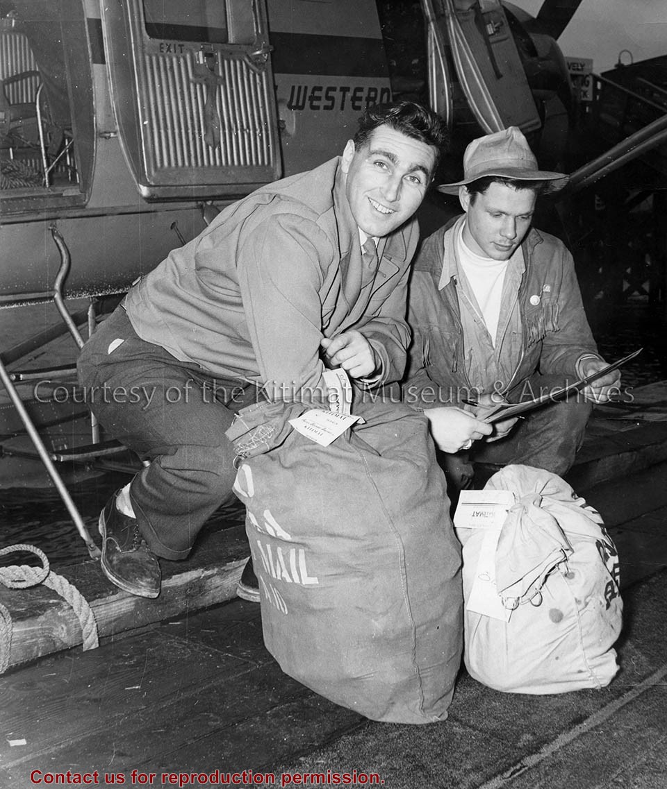
Photo depicts two men kneeling beside the first bags of mail to arrive via Pacific Western Airlines. On the right, Captain T. M. Kellough for PWA delivers the bags to on the left, Kitimat Express driver Lloyd Kaberg, at the wharf, Smeltersite. Northern Sentinel Press Collection
Photo depicts two men kneeling beside the first bags of mail to arrive via Pacific Western Airlines. On the right, Captain T. M. Kellough for PWA delivers the bags to on the left, Kitimat Express driver Lloyd Kaberg, at the wharf, Smeltersite. Northern Sentinel Press Collection