Photograph of aerial looking south-east across neighbourhood A with neighbourhood A-II clearing in foreground and Minette Bay in the background. Nechako Centre and School are visible.
Donated by Jackie Worboys. Given to the Jackie Mufford Worboys family by Wally Melville.
Scope and Content
Photograph of aerial looking south-east across neighbourhood A with neighbourhood A-II clearing in foreground and Minette Bay in the background. Nechako Centre and School are visible.
Photograph of clearing for machine shop site and storage yard, Moore Creek camp in background, looking east. Wood and debris being burned in centre. Truck parked in foreground.
Bud Powell is a longtime resident of Kitimat and former smeltersite resident. He worked for Alcan.
Custodial History
Donated by Bud Powell.
Scope and Content
Photograph of clearing for machine shop site and storage yard, Moore Creek camp in background, looking east. Wood and debris being burned in centre. Truck parked in foreground.
Photograph of clearing of site for machine shop and plant yard, Moore Creek, looking north. Wood and debris being burned in centre. Truck and other machinery in front of that.
Bud Powell is a longtime resident of Kitimat and former smeltersite resident. He worked for Alcan.
Custodial History
Donated by Bud Powell.
Scope and Content
Photograph of clearing of site for machine shop and plant yard, Moore Creek, looking north. Wood and debris being burned in centre. Truck and other machinery in front of that.
Photograph of Mrs. P.E. Radley planting the first tree on the south edge of the Nechako Centre. Two other men are around her. Nechako Centre and vehicles visible in background.
Donated by Jackie Worboys. Given to the Jackie Mufford Worboys family by Wally Melville.
Scope and Content
Photograph of Mrs. P.E. Radley planting the first tree on the south edge of the Nechako Centre. Two other men are around her. Nechako Centre and vehicles visible in background.
Photograph of showing paving machine in operation on Haisla Blvd. between Nalabila and Kingfisher Ave. Six men visible working, with two operating paving vehicles. Side of paving machine reads "Barber Greene".
Donated by Jackie Worboys. Given to the Jackie Mufford Worboys family by Wally Melville.
Scope and Content
Photograph of showing paving machine in operation on Haisla Blvd. between Nalabila and Kingfisher Ave. Six men visible working, with two operating paving vehicles. Side of paving machine reads "Barber Greene".
Photograph of aerial view looking south showing potline group "B", part of precast yard in foreground and group "A" in background. Douglas Channel visible behind.
Bud Powell is a longtime resident of Kitimat and former smeltersite resident. He worked for Alcan.
Custodial History
Donated by Bud Powell.
Scope and Content
Photograph of aerial view looking south showing potline group "B", part of precast yard in foreground and group "A" in background. Douglas Channel visible behind.
Photograph of pre-cast concrete yard looking north-west from rectifier building #102. Many men and work. Lots of buildings visible behind. A little bit of snow on the slope behind buildings.
Bud Powell is a longtime resident of Kitimat and former smeltersite resident. He worked for Alcan.
Custodial History
Donated by Bud Powell.
Scope and Content
Photograph of pre-cast concrete yard looking north-west from rectifier building #102. Many men and work. Lots of buildings visible behind. A little bit of snow on the slope behind buildings.
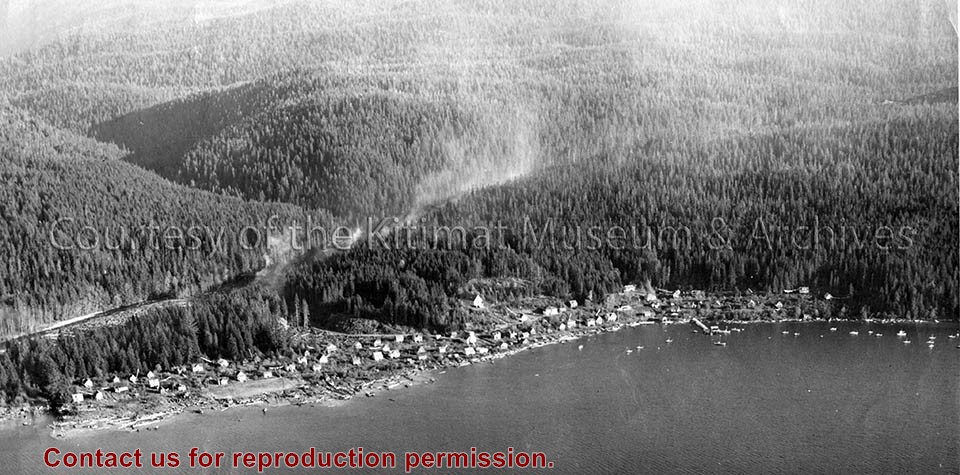
Photo depicts a slash burning on the transmission line right-of-way behind Kitamaat Village.
Notes
Title based on content of photograph. Fred DeLory, Alcan's Resident Engineer at smeltersite, was one of two who signed the incorporation papers for the town of Kitimat. Fred DeLory Collection 2002.15
Photograph of view looking north, showing south approach to Moore Creek highway bridge at left. Vehicles on road and parked around. Buildings at right.
Bud Powell is a longtime resident of Kitimat and former smeltersite resident. He worked for Alcan.
Custodial History
Donated by Bud Powell.
Scope and Content
Photograph of view looking north, showing south approach to Moore Creek highway bridge at left. Vehicles on road and parked around. Buildings at right.