Photograph of neighbourhood C to the south of the 200 temporary housing units showing precast wall panels for septic tank being lifted into space. Men and crane are visible working.
Donated by Jackie Worboys. Given to the Jackie Mufford Worboys family by Wally Melville.
Scope and Content
Photograph of neighbourhood C to the south of the 200 temporary housing units showing precast wall panels for septic tank being lifted into space. Men and crane are visible working.
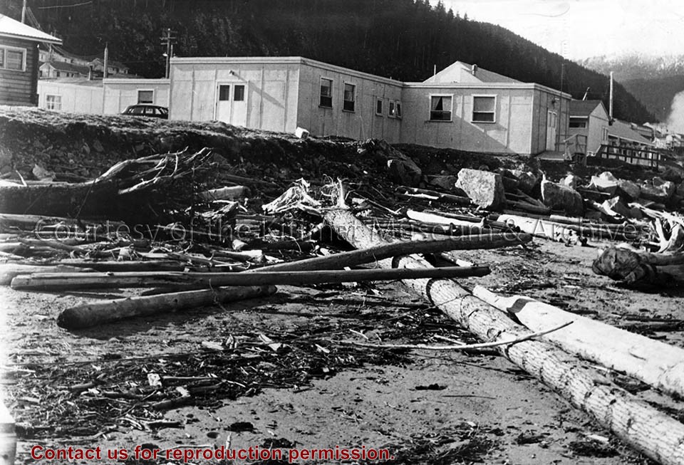
Flood looking upstream of Neighbourhood C Drainage Canal from approx. station 25/00. Note silt etc. in canal. Section of canal in immediate foreground was cut to shape just prior to the flood.
Flood looking upstream of Neighbourhood C Drainage Canal from approx. station 25/00. Note silt etc. in canal. Section of canal in immediate foreground was cut to shape just prior to the flood.
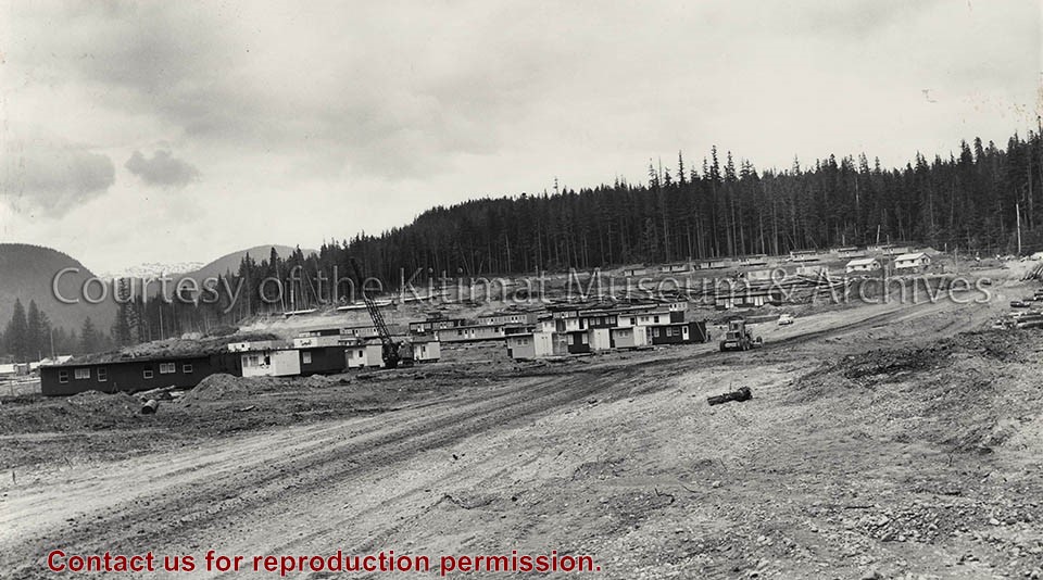
Photo depicts flat-top temporary housing lining the hillside up to the Aluminum City Motel at the treeline. View is northwest. Grader on Kuldo Boulevard.
Photo depicts flat-top temporary housing lining the hillside up to the Aluminum City Motel at the treeline. View is northwest. Grader on Kuldo Boulevard.
Notes
Title based on content of photograph. -- Alcan Negative No. 29337. -- The circus tent assembly line was erected . Temporary housing destined for Kitimat was assembled at Vancouver Tug and Barge below the Lion's Gate Bridge in three sections, then barged to Kitimat - 10 houses or 30 sections on each barge. -- Electrician Bill Frahler wired approximately 2,000 houses in Kitimat camps and townsite between 1954 and 1958, working first for Johnson-Crooks then Straits Construction, both U.S. contractors. 73.3.6.6
Photograph of temporary weir in main drainage channel below Columbia Ave. bridge, taken on Saturday 23rd Nov after the heavy rain and snow. Note the debris on the structure and part of the bank scoured away. The flow of water cut down the bed of channel approximately 2' in this area.
Photograph of temporary weir in main drainage channel below Columbia Ave. bridge, taken on Saturday 23rd Nov after the heavy rain and snow. Note the debris on the structure and part of the bank scoured away. The flow of water cut down the bed of channel approximately 2' in this area.
Photograph of view looking south showing excavation for footings and formwork for local service buildings in priority area No.1, potline group B. Some vehicles visible. Potlines visible in background.
Bud Powell is a longtime resident of Kitimat and former smeltersite resident. He worked for Alcan.
Custodial History
Donated by Bud Powell.
Scope and Content
Photograph of view looking south showing excavation for footings and formwork for local service buildings in priority area No.1, potline group B. Some vehicles visible. Potlines visible in background.
Photograph of view looking south showing excavation to elevation 54 in potline 9 area. Area is cleared with machinery working. Potlines visible in background.
Bud Powell is a longtime resident of Kitimat and former smeltersite resident. He worked for Alcan.
Custodial History
Donated by Bud Powell.
Scope and Content
Photograph of view looking south showing excavation to elevation 54 in potline 9 area. Area is cleared with machinery working. Potlines visible in background.
Photograph of excavation for Kelly Douglas supermarket in the City Centre. Commonwealth construction has the contract for this building. There is currently a foundation hole dug. In the foreground is a pile of cinderblocks and a car. Up on the hill in the background, Albatross homes are visible.
Donated by Jackie Worboys. Given to the Jackie Mufford Worboys family by Wally Melville.
Scope and Content
Photograph of excavation for Kelly Douglas supermarket in the City Centre. Commonwealth construction has the contract for this building. There is currently a foundation hole dug. In the foreground is a pile of cinderblocks and a car. Up on the hill in the background, Albatross homes are visible.