Photograph of aerial of east side of Nechako area. Widgeon, Wren, Apartments, Partridge, and Pintail in foreground with more streets behind. Houses are built.
Donated by Jackie Worboys. Given to the Jackie Mufford Worboys family by Wally Melville.
Scope and Content
Photograph of aerial of east side of Nechako area. Widgeon, Wren, Apartments, Partridge, and Pintail in foreground with more streets behind. Houses are built.
Photograph of aerial of west side of Nechako area. Petrel, Plover, Aprtments, Osprey and Oriole in foreground with more streets behind. Houses are built. Fire station, United Church, Nechako Centre and School are visible.
Donated by Jackie Worboys. Given to the Jackie Mufford Worboys family by Wally Melville.
Scope and Content
Photograph of aerial of west side of Nechako area. Petrel, Plover, Aprtments, Osprey and Oriole in foreground with more streets behind. Houses are built. Fire station, United Church, Nechako Centre and School are visible.
Photograph of aerial view looking south-west across Teal and Swallow Streets towards the Nechako Centre School and commercial buildings in neighbourhood A-I. Many houses still under construction. Portables can be seen outside Nechako School.
Donated by Jackie Worboys. Given to the Jackie Mufford Worboys family by Wally Melville.
Scope and Content
Photograph of aerial view looking south-west across Teal and Swallow Streets towards the Nechako Centre School and commercial buildings in neighbourhood A-I. Many houses still under construction. Portables can be seen outside Nechako School.
Photograph of southern edge of smeltersite, looking east. Side slopes of gravel fill being completed to grade. Truck dumping gravel, and workers visible. Powerlines along left side.
Bud Powell is a longtime resident of Kitimat and former smeltersite resident. He worked for Alcan.
Custodial History
Donated by Bud Powell.
Scope and Content
Photograph of southern edge of smeltersite, looking east. Side slopes of gravel fill being completed to grade. Truck dumping gravel, and workers visible. Powerlines along left side.
Photograph of aerial view looking south showing overall view of potline group "B" and part of group "A". Further potlines look completed, and closer ones still under construction. Cleared area with building material in front.
Bud Powell is a longtime resident of Kitimat and former smeltersite resident. He worked for Alcan.
Custodial History
Donated by Bud Powell.
Scope and Content
Photograph of aerial view looking south showing overall view of potline group "B" and part of group "A". Further potlines look completed, and closer ones still under construction. Cleared area with building material in front.
Photograph of aerial view of neighbourhood C. Note debris piles and logs in area C-II in the foreground. Kitlope, Kootney, Capilano, snd Babine streets visible with completed homes.
Land clearing of Kitimat. All aerials for development.
Custodial History
From the files of Ray Hunstone. Photos from an Alcan binder, have Alcan numbers.
Scope and Content
Photograph of aerial view of neighbourhood C. Note debris piles and logs in area C-II in the foreground. Kitlope, Kootney, Capilano, snd Babine streets visible with completed homes.
Photograph of cinema under construction in the Nechako Centre, neighbourhood A. Framework and brickwork is being built. A boardwalk is in the foreground. Houses visible in the background.
Donated by Jackie Worboys. Given to the Jackie Mufford Worboys family by Wally Melville.
Scope and Content
Photograph of cinema under construction in the Nechako Centre, neighbourhood A. Framework and brickwork is being built. A boardwalk is in the foreground. Houses visible in the background.
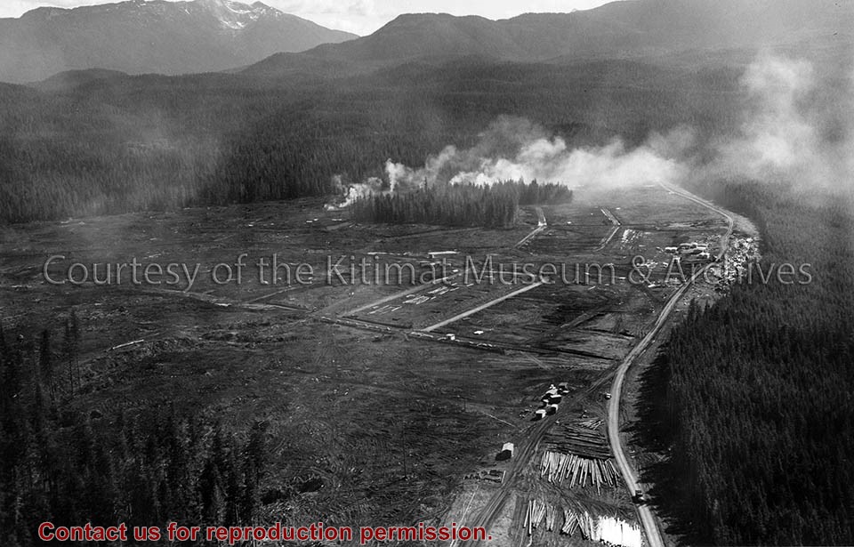
Photograph of aerial photograph taken from over townsite camp looking toward City Centre showing extent of clearing in C-I area. Haisla Blvd. can be seen on left-hand side of the picture. At bottom a single structure can be seen. Some snow is behind it. In the very back Douglas Channel is visible.
Donated by Jackie Worboys. Given to the Jackie Mufford Worboys family by Wally Melville.
Scope and Content
Photograph of aerial photograph taken from over townsite camp looking toward City Centre showing extent of clearing in C-I area. Haisla Blvd. can be seen on left-hand side of the picture. At bottom a single structure can be seen. Some snow is behind it. In the very back Douglas Channel is visible.