Folder containing research material.
Photographs of early Kitimat. People at snowy home, Christ the King Catholic Parish construction, man with rolled out document, men in suits with shovel, Kitimat homes, Baptist Church and interior, licing quarters, homes being floated, snowy building with coffee bar and commisary sign, Kitimat The Aluminum Centre of British Columbia Welcomes You sign, man in front of church and trailer, and redeemer Lutheran Church sign with cleared lot.
Collection of materials that Patricia Robertson used for her PhD.
Custodial History
Donated to the museum by Patricia Robertson.
Scope and Content
Folder containing research material.
Photographs of early Kitimat. People at snowy home, Christ the King Catholic Parish construction, man with rolled out document, men in suits with shovel, Kitimat homes, Baptist Church and interior, licing quarters, homes being floated, snowy building with coffee bar and commisary sign, Kitimat The Aluminum Centre of British Columbia Welcomes You sign, man in front of church and trailer, and redeemer Lutheran Church sign with cleared lot.
Notes
Note inside reading: Dear Pat. Though these do not look too good a lot can be done to and with them if you choose to use them in the book - the negs we have. Cheers Gisela.
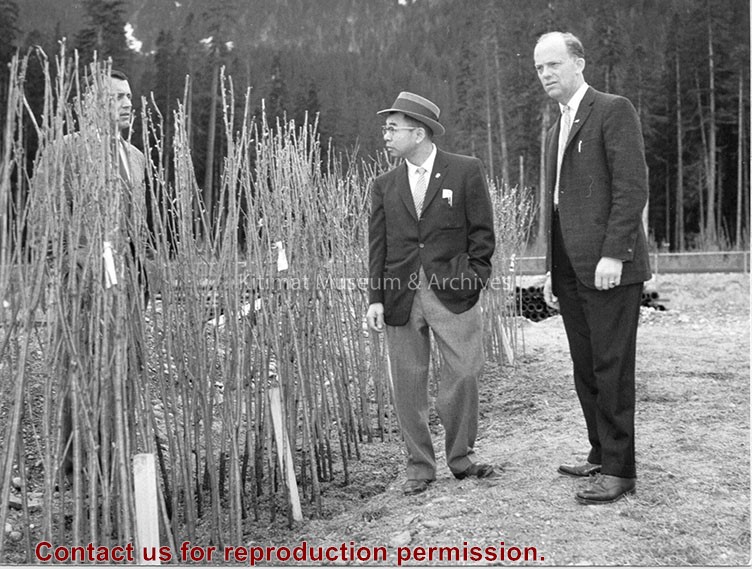
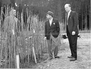
Photo showing Minori Nishi (centre) and his gift to the town: 300 Japanese flowering cherry trees. Norman Barber (left) and Municipal Manager Art Currie (right) looking on.
Photo showing Minori Nishi (centre) and his gift to the town: 300 Japanese flowering cherry trees. Norman Barber (left) and Municipal Manager Art Currie (right) looking on.
Photograph of an aerial view the the Alcan plant and Kitimat River Delta. Alcan plant is visible above while the delta is below.
Notes
Back of photo has 2 dates, Jan 23 1985 and Jan 23 1986. The 1986 date is a sticker add on, while the 1985 date is stamped on. The 1985 date is believed to be correct.
Photograph of an aerial view of the Eurocan, Ocelot, and Alcan docks, as well as the Alcan plant. Kitimat River estuary visible on bottom right.
Notes
Back of photo has 2 dates, Jan 23 1985 and Jan 23 1986. The 1986 date is a sticker add on, while the 1985 date is stamped on. The 1985 date is believed to be correct.
Photograph of an aerial view the Ocelot Methanol Plant. Smoke is visible coming from the facility. On the top right Eurocan can be seen, and on the top left is Alcan. Kitimat River below.
Photograph of an aerial view the Ocelot Methanol Plant. Smoke is visible coming from the facility. On the top right Eurocan can be seen, and on the top left is Alcan. Kitimat River below.
Notes
Back of photo has 2 dates, Jan 23 1985 and Jan 23 1986. The 1986 date is a sticker add on, while the 1985 date is stamped on. The 1985 date is believed to be correct.
Photograph of aerial view looking north at the plant site, with H.M.C.S. Sioux at the wharf. Tide elevation is approximately 2.5 feet, and the extent of the dredge cut in the harbour can be clearly seen.
Bill was one of the superintendents with Saguenay Kitimat.
Custodial History
Donated by Joanna Gallacher
Scope and Content
Photograph of aerial view looking north at the plant site, with H.M.C.S. Sioux at the wharf. Tide elevation is approximately 2.5 feet, and the extent of the dredge cut in the harbour can be clearly seen.
Aerial view looking north at the plant site, with H.M.C.S. Sioux at the wharf. Tide elevation is approximately 2.5 feet, and the extent of the dredge cut in the harbour can be clearly seen.
In Klaus Mueller's possession when Engineering Depart. was dismantled.
Scope and Content
Aerial view looking north at the plant site, with H.M.C.S. Sioux at the wharf. Tide elevation is approximately 2.5 feet, and the extent of the dredge cut in the harbour can be clearly seen.