Photograph of result of first clearing shown in BC-2-142. Note size of trees and condition of logs. Trees are cut/knocked down. Other trees still standing behind.
Bud Powell is a longtime resident of Kitimat and former smeltersite resident. He worked for Alcan.
Custodial History
Donated by Bud Powell.
Scope and Content
Photograph of result of first clearing shown in BC-2-142. Note size of trees and condition of logs. Trees are cut/knocked down. Other trees still standing behind.
Black covered book titled "Kitimat Townsite Report". No. A-33 Mr. J.E. Dudley. Contains info about early Kitimat and planning. Inside front cover are some loose pages with town plans.
Bud Powell is a longtime resident of Kitimat and former smeltersite resident. He worked for Alcan.
Custodial History
Donated by Bud Powell.
Scope and Content
Black covered book titled "Kitimat Townsite Report". No. A-33 Mr. J.E. Dudley. Contains info about early Kitimat and planning. Inside front cover are some loose pages with town plans.
Photograph of gully crossing #2 showing the clearing contractor placing the dead and diseased trees at the base of the gully to stop any further earth slippage and improve the appearance of the area. Houses visble on hill behind.
Land clearing of Kitimat. All aerials for development.
Custodial History
From the files of Ray Hunstone. Photos from an Alcan binder, have Alcan numbers.
Scope and Content
Photograph of gully crossing #2 showing the clearing contractor placing the dead and diseased trees at the base of the gully to stop any further earth slippage and improve the appearance of the area. Houses visble on hill behind.
Photograph of aerial picture looking south-east across Kitimat Townsite showing falling in neighbourhood B-IV in the foreground and Minette Bay in the background.
Donated by Jackie Worboys. Given to the Jackie Mufford Worboys family by Wally Melville.
Scope and Content
Photograph of aerial picture looking south-east across Kitimat Townsite showing falling in neighbourhood B-IV in the foreground and Minette Bay in the background.
Photograph of one of the bridges on the No.2 electrical transmission line to the townsite. This bridge was swept away on the night of the 22nd and 23rd of Novemeber. Bridge is sitting in the river.
Donated by Jackie Worboys. Given to the Jackie Mufford Worboys family by Wally Melville.
Scope and Content
Photograph of one of the bridges on the No.2 electrical transmission line to the townsite. This bridge was swept away on the night of the 22nd and 23rd of Novemeber. Bridge is sitting in the river.
Photograph of aerial view looking towards the west of the Kitimat Townsite with neighbourhood A-I in the foreground. City Centre clearing in background with slash burning smoke.
Donated by Jackie Worboys. Given to the Jackie Mufford Worboys family by Wally Melville.
Scope and Content
Photograph of aerial view looking towards the west of the Kitimat Townsite with neighbourhood A-I in the foreground. City Centre clearing in background with slash burning smoke.
Photograph of view from roof of Mess Hall in Riverlodge showing dormitories A to G inclusive. Vehicles are parked outisde, and driving on the road around buildings.
Donated by Jackie Worboys. Given to the Jackie Mufford Worboys family by Wally Melville.
Scope and Content
Photograph of view from roof of Mess Hall in Riverlodge showing dormitories A to G inclusive. Vehicles are parked outisde, and driving on the road around buildings.
Photograph of linemen stringing cable on road 2 in neighbourhood A-II. Two men are working below and two other men are up on the pole. Another man is on the ground to the right. There are houses around, and a machine on the left.
Donated by Jackie Worboys. Given to the Jackie Mufford Worboys family by Wally Melville.
Scope and Content
Photograph of linemen stringing cable on road 2 in neighbourhood A-II. Two men are working below and two other men are up on the pole. Another man is on the ground to the right. There are houses around, and a machine on the left.
Photograph of aerial view looking west showing C-II clearing in lower left hand corner, low rental housing area and neighbourhood C-I in centre, and new camp site clearing left-centre. Camp is at Riverlodge site. Kitimat River bridge visible behind. Lots of snow on ground.
Donated by Jackie Worboys. Given to the Jackie Mufford Worboys family by Wally Melville.
Scope and Content
Photograph of aerial view looking west showing C-II clearing in lower left hand corner, low rental housing area and neighbourhood C-I in centre, and new camp site clearing left-centre. Camp is at Riverlodge site. Kitimat River bridge visible behind. Lots of snow on ground.
Photograph of neighbourhood B-I showing smoke from burning operations in the background and stripping road "b" in the foreground. Men standing next to base of a machine on the right.
Land clearing of Kitimat. All aerials for development.
Custodial History
From the files of Ray Hunstone. Photos from an Alcan binder, have Alcan numbers.
Scope and Content
Photograph of neighbourhood B-I showing smoke from burning operations in the background and stripping road "b" in the foreground. Men standing next to base of a machine on the right.
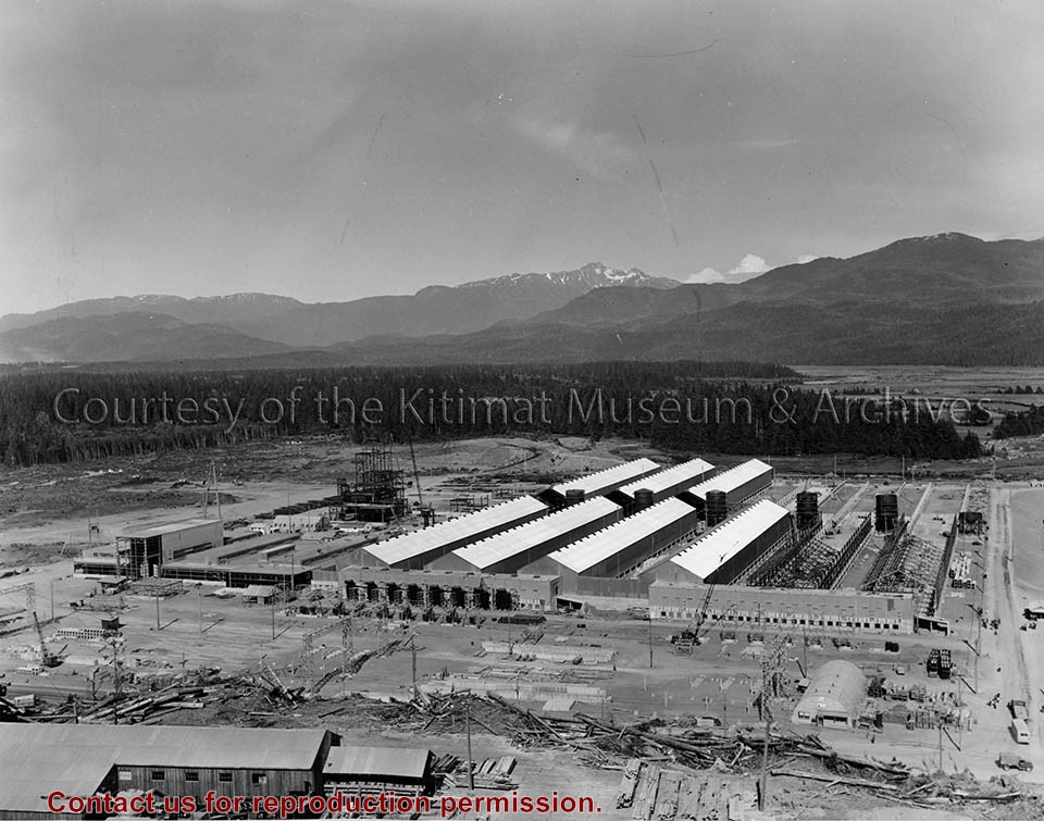
Photograph of asphalt paving being placed on the Service Centre road between the Public Works building and the railway. Seven men visible working. Sandhill in background on the right.
Donated by Jackie Worboys. Given to the Jackie Mufford Worboys family by Wally Melville.
Scope and Content
Photograph of asphalt paving being placed on the Service Centre road between the Public Works building and the railway. Seven men visible working. Sandhill in background on the right.