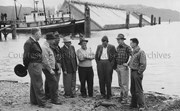
Photo depicts a group of men concerned with the caisson dock construction. From left is Messrs., Cam Jenkinson, George Malby, McCallum, Hal Whiting, J. B. Whitton, S. T. Wynne-Jones, Van Houten and Dick Hermann. View is of three floating caissons that were being towed into position for sinking, creating the smelter dock.
Photo depicts a group of men concerned with the caisson dock construction. From left is Messrs., Cam Jenkinson, George Malby, McCallum, Hal Whiting, J. B. Whitton, S. T. Wynne-Jones, Van Houten and Dick Hermann. View is of three floating caissons that were being towed into position for sinking, creating the smelter dock.
Notes
Title based on content of photograph. -- Alcan ID No. BC-2-362. -- Messrs. Jenkinson, Wynne-Jones, and Hermann all work for Alcan Engineering under the Resident Engineer George Malby. Messrs. J.B. Whitton and Van Houten work for the consulting firm of Frederick R. Harris & Co. of New York, N.Y. Hal Whiting was Project Manager, Kitimat Constructors, for smelter and town construction. Hal Whiting Collection 985.65.212
Aerial photo of the Kitimat Region. Includes the Kitimat estuary, the Alcan smelter site and in the distance, the Kitimat City Centre. Taken from the southwest.
Aerial photo of the Kitimat Region. Includes the Kitimat estuary, the Alcan smelter site and in the distance, the Kitimat City Centre. Taken from the southwest.
Negatives showing aerials & ground images of the Eurocan Pulp & Paper Mill with visual signs of parts of the mill in operation. A couple negatives show the town of Kitimat with Eurocan in the distant background.
Negatives showing aerials & ground images of the Eurocan Pulp & Paper Mill with visual signs of parts of the mill in operation. A couple negatives show the town of Kitimat with Eurocan in the distant background.
Photo depicts an aerial view of Kitimat. Seen is land cleared for Neighbourhood "D" and the Whitesail Neighbourhood under construction, right foreground. The Alcan smelter and channel are in the background.
Photo depicts an aerial view of Kitimat. Seen is land cleared for Neighbourhood "D" and the Whitesail Neighbourhood under construction, right foreground. The Alcan smelter and channel are in the background.
Notes
Title based on content of photograph. -- On the official "Town Plan for Kitimat, B.C." by Stein and Mayer & Whittlesey, Neighbourhood "D", the cleared area in the photo, was to have three elementary schools, and one junior and one senior high school. This neighbourhood was never constructed and was returned to bush.