Photograph of aerial looking south-east across neighbourhood A with neighbourhood A-II clearing in foreground and Minette Bay in the background. Nechako Centre and School are visible.
Donated by Jackie Worboys. Given to the Jackie Mufford Worboys family by Wally Melville.
Scope and Content
Photograph of aerial looking south-east across neighbourhood A with neighbourhood A-II clearing in foreground and Minette Bay in the background. Nechako Centre and School are visible.
Photograph of aerial photograph looking west across neighbourhood C. Logs in lower right-hand corner are now being removed. In the background is the Riverlodge camp, with the dyke behind it. On top towards the right, the Kitimat River bridge is just visible.
Donated by Jackie Worboys. Given to the Jackie Mufford Worboys family by Wally Melville.
Scope and Content
Photograph of aerial photograph looking west across neighbourhood C. Logs in lower right-hand corner are now being removed. In the background is the Riverlodge camp, with the dyke behind it. On top towards the right, the Kitimat River bridge is just visible.
Photograph of aerial view looking north-east across neighbourhood A-I with Petrel and Oriole Streets in the foreground. Nechako Centre and School visible behind.
Donated by Jackie Worboys. Given to the Jackie Mufford Worboys family by Wally Melville.
Scope and Content
Photograph of aerial view looking north-east across neighbourhood A-I with Petrel and Oriole Streets in the foreground. Nechako Centre and School visible behind.
Photograph of aerial view looking east across neighbourhood A-III and A-I. Note in upper left centre a portion of the concrete walks already constructed, which eventually will lead to Kingfisher underpass. Also note contrast between landscaped areas and those surrounding the houses now under construction. Gyrfaclon street in centre. Nechako Centre and School visible at upper left. Nechako school has protables outside.
Donated by Jackie Worboys. Given to the Jackie Mufford Worboys family by Wally Melville.
Scope and Content
Photograph of aerial view looking east across neighbourhood A-III and A-I. Note in upper left centre a portion of the concrete walks already constructed, which eventually will lead to Kingfisher underpass. Also note contrast between landscaped areas and those surrounding the houses now under construction. Gyrfaclon street in centre. Nechako Centre and School visible at upper left. Nechako school has protables outside.
Photograph of aerial photograph looking east toward neighbourhood A with the City Centre clearing in the right-hand foreground and neighbourhood A-IV clearing in the centre foreground.
Donated by Jackie Worboys. Given to the Jackie Mufford Worboys family by Wally Melville.
Scope and Content
Photograph of aerial photograph looking east toward neighbourhood A with the City Centre clearing in the right-hand foreground and neighbourhood A-IV clearing in the centre foreground.
Photograph of aerial view looking southeast across neighbourhood A-I towards Minette Bay. Note timber felled for the B-I High School site in the foreground.
Donated by Jackie Worboys. Given to the Jackie Mufford Worboys family by Wally Melville.
Scope and Content
Photograph of aerial view looking southeast across neighbourhood A-I towards Minette Bay. Note timber felled for the B-I High School site in the foreground.
Photograph of aerial view looking towards the west of the Kitimat Townsite with neighbourhood A-I in the foreground. City Centre clearing in background with slash burning smoke.
Donated by Jackie Worboys. Given to the Jackie Mufford Worboys family by Wally Melville.
Scope and Content
Photograph of aerial view looking towards the west of the Kitimat Townsite with neighbourhood A-I in the foreground. City Centre clearing in background with slash burning smoke.
Photograph of #2 guest house showing installation of amdeck roofing. Three men visible working on the roof, one man is going down on a ladder, and another man is on the ground below. Building material is piled on the ground. Ground is very wet.
Donated by Jackie Worboys. Given to the Jackie Mufford Worboys family by Wally Melville.
Scope and Content
Photograph of #2 guest house showing installation of amdeck roofing. Three men visible working on the roof, one man is going down on a ladder, and another man is on the ground below. Building material is piled on the ground. Ground is very wet.
Photograph of aerial view of alumina storage area looking west and showing surcharge in stage 1 position. Note new scow grid and salt water pumphouse in foreground.
Bud Powell is a longtime resident of Kitimat and former smeltersite resident. He worked for Alcan.
Custodial History
Donated by Bud Powell.
Scope and Content
Photograph of aerial view of alumina storage area looking west and showing surcharge in stage 1 position. Note new scow grid and salt water pumphouse in foreground.
Photograph of Boyles Brothers setting up their drilling equipment in the City Centre. A hundred foot test hole is to be placed in this location. There are four men visible working. A crane is in the background on the right.
Donated by Jackie Worboys. Given to the Jackie Mufford Worboys family by Wally Melville.
Scope and Content
Photograph of Boyles Brothers setting up their drilling equipment in the City Centre. A hundred foot test hole is to be placed in this location. There are four men visible working. A crane is in the background on the right.
Photograph of showing the framing almost completed in Guest House No.2. Two men are visible working on it. Apartments visible behind, and townsite camp is to the left.
Donated by Jackie Worboys. Given to the Jackie Mufford Worboys family by Wally Melville.
Scope and Content
Photograph of showing the framing almost completed in Guest House No.2. Two men are visible working on it. Apartments visible behind, and townsite camp is to the left.
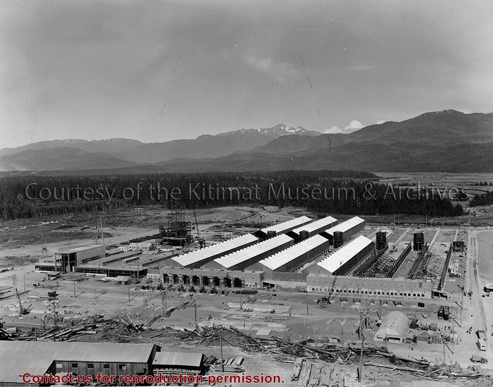
Photograph of view looking east showing progress of potline 2, alumina storage bins and sub-station 2. Area under construction, construction material in foreground.
Bud Powell is a longtime resident of Kitimat and former smeltersite resident. He worked for Alcan.
Custodial History
Donated by Bud Powell.
Scope and Content
Photograph of view looking east showing progress of potline 2, alumina storage bins and sub-station 2. Area under construction, construction material in foreground.
Photograph of gully crossing #2 showing the clearing contractor placing the dead and diseased trees at the base of the gully to stop any further earth slippage and improve the appearance of the area. Houses visble on hill behind.
Land clearing of Kitimat. All aerials for development.
Custodial History
From the files of Ray Hunstone. Photos from an Alcan binder, have Alcan numbers.
Scope and Content
Photograph of gully crossing #2 showing the clearing contractor placing the dead and diseased trees at the base of the gully to stop any further earth slippage and improve the appearance of the area. Houses visble on hill behind.