Aerial view of the townsite clearing looking North. Note, City Centre in left foreground with clearing for main sewer outfall extending across to the lower right hand corner of photograph
Aerial view of the townsite clearing looking North. Note, City Centre in left foreground with clearing for main sewer outfall extending across to the lower right hand corner of photograph
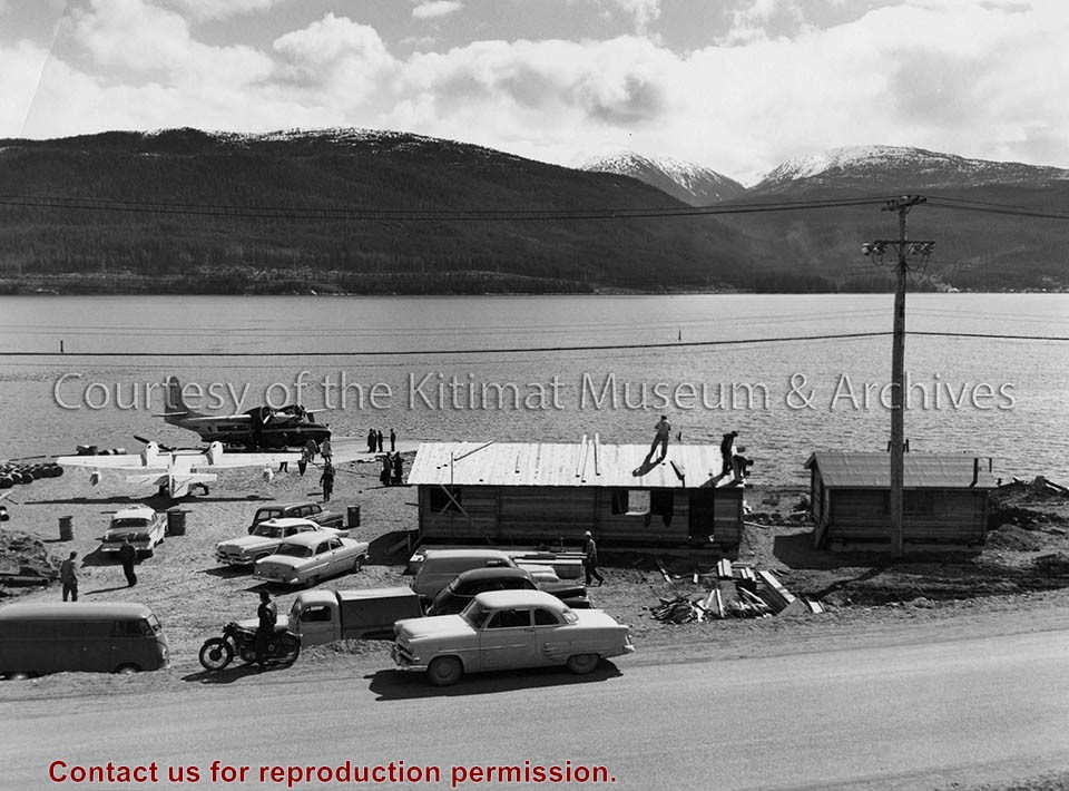
Photo depicts construction of two pan-abode waiting rooms on the beach at Smeltersite for Pacific Western Airlines. A "Mallard" amphibian airplane unloads on the landing ramp in the background.
Photo depicts construction of two pan-abode waiting rooms on the beach at Smeltersite for Pacific Western Airlines. A "Mallard" amphibian airplane unloads on the landing ramp in the background.
Notes
Pan-Abode is interlocking red cedar building materials invented in 1948 in British Columbia. The builders of Kitimat chose innovative materials such as Pan-Abode for the town. Pan-Abode was used in some of the first prototype homes on Kitimat's first streets - Oriole, Pintail, and Partridge. It is also an efficient building material as a structure can be assembled very quickly. Northern Sentinel Press Collection. P00226.jpg
Photo depicts an aerial view looking northwest of Smeltersite housing, the hospital on the beach, the school in the centre, and the seaplane landing ramp.
Photo depicts an aerial view looking northwest of Smeltersite housing, the hospital on the beach, the school in the centre, and the seaplane landing ramp.
Notes
Title based on content of photograph. -- Alcan ID No. J-43-1837. Kitimat Heritage Advisory Commission Collection. KMA No. P00209.jpg
Photo depicts an aerial view of Kitimat. Seen is land cleared for Neighbourhood "D" and the Whitesail Neighbourhood under construction, right foreground. The Alcan smelter and channel are in the background.
Photo depicts an aerial view of Kitimat. Seen is land cleared for Neighbourhood "D" and the Whitesail Neighbourhood under construction, right foreground. The Alcan smelter and channel are in the background.
Notes
Title based on content of photograph. -- On the official "Town Plan for Kitimat, B.C." by Stein and Mayer & Whittlesey, Neighbourhood "D", the cleared area in the photo, was to have three elementary schools, and one junior and one senior high school. This neighbourhood was never constructed and was returned to bush.
Aerial photo of the Kitimat river estuary showing Kitimat River, Kitimat Harbor, Minette Bay, and the Alcan company smelter site taken from the southwest looking northeast towards the Kitimat City Centre.
Aerial photo of the Kitimat river estuary showing Kitimat River, Kitimat Harbor, Minette Bay, and the Alcan company smelter site taken from the southwest looking northeast towards the Kitimat City Centre.
Aerial photo of the Kitimat Region. Includes the Kitimat estuary, the Alcan smelter site and in the distance, the Kitimat City Centre. Taken from the southwest.
Aerial photo of the Kitimat Region. Includes the Kitimat estuary, the Alcan smelter site and in the distance, the Kitimat City Centre. Taken from the southwest.