Jamieson came to Kitimat from Vancouver to work on the Alcan project in 1952. With his first pay cheque he bought a small "Pony Kodak" camera at the local store (Hudson Bay?), and started taking coloured slides of the Kitimat from 1952-1953. Left Kitimat at the end of August 1953 to move to Montreal.
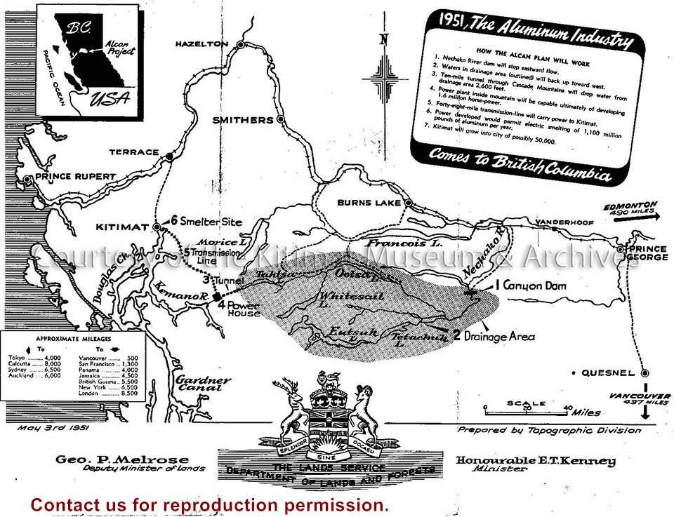
2 sheets. Lot map and and demand for lots article, and map of Kitamaat area.
Physical Condition
Good
Material
paper
Height
56cm
Width
44cm
Inscriptions
Kitamaat. The coming North Pacific metropolis of Canada. Demand for Lots. location and advantages.
Plan Shewing Kitamaat Townsite at head of Kitimat Arm
Map of the Northern Coast part of British Columbia
Northern Sentinel: Box #4: (A) Historical (1) District of Kitimat (a) Town Planning (i) Mayer, Whittlesey and Glass, New York (ii) Resident Planning Engineer
Scope and Content
Photo showing (Municipal) map of area of the corporation of the District of Kitimat.
Printed map of Kitimat from 1959. The old hospital is in place but the Museum isn't. Angle St. is identified as Alger St., and Gwyn St. is Faraday St. Riverlodge Camp is still in place.
Pat Lean was the Provincial Government Agent in Kitimat from Dec 1 1969 to April 1 1970.
Scope and Content
Printed map of Kitimat from 1959. The old hospital is in place but the Museum isn't. Angle St. is identified as Alger St., and Gwyn St. is Faraday St. Riverlodge Camp is still in place.
Photograph showing two women looking at a map. One of the women is wearing a scarf over her hair and a coat, the other woman is wearing a knit button up sweater. Both of them are wearing glasses. In the foreground of the women, there is a projector sitting on a table. Part of the Loggers Supplement 1972.
Photograph showing two women looking at a map. One of the women is wearing a scarf over her hair and a coat, the other woman is wearing a knit button up sweater. Both of them are wearing glasses. In the foreground of the women, there is a projector sitting on a table. Part of the Loggers Supplement 1972.