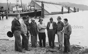
Photo depicts a group of men concerned with the caisson dock construction. From left is Messrs., Cam Jenkinson, George Malby, McCallum, Hal Whiting, J. B. Whitton, S. T. Wynne-Jones, Van Houten and Dick Hermann. View is of three floating caissons that were being towed into position for sinking, creating the smelter dock.
Photo depicts a group of men concerned with the caisson dock construction. From left is Messrs., Cam Jenkinson, George Malby, McCallum, Hal Whiting, J. B. Whitton, S. T. Wynne-Jones, Van Houten and Dick Hermann. View is of three floating caissons that were being towed into position for sinking, creating the smelter dock.
Notes
Title based on content of photograph. -- Alcan ID No. BC-2-362. -- Messrs. Jenkinson, Wynne-Jones, and Hermann all work for Alcan Engineering under the Resident Engineer George Malby. Messrs. J.B. Whitton and Van Houten work for the consulting firm of Frederick R. Harris & Co. of New York, N.Y. Hal Whiting was Project Manager, Kitimat Constructors, for smelter and town construction. Hal Whiting Collection 985.65.212
Photograph of the Recreation Hall. Back of photograph reads: 'The Rec Hall & The Shoe Horn - shoe repair shop was the first private enterprise in Kitimat.'
Photograph taken by Dave Geddes, Bank of Montreal, and given to Sylvia Anderson
Scope and Content
Photograph of the Recreation Hall. Back of photograph reads: 'The Rec Hall & The Shoe Horn - shoe repair shop was the first private enterprise in Kitimat.'
John Ware was a past employee of the Kitimat Town Planning Department (1957-1959). He was hired by Hollister Kent, Planning Director for Kitimat. During his two years here, Dr. ware designed the first Kitimat street signs, the Haisla Boulevard overpass, and the Hirsch Creek Park shelter centennial project (1858-1958). He was layed off when Alcan lost major Aluminum buyers and the town expansion halted, resulting in a cut back of Kirtimat employees. He then moved to the USA.
Custodial History
Donated by John Ware.
Scope and Content
Photographs of multipurpose recreation building sketch perspectives. Kitimat.
Map, of the District Municipality of Kitimat, British Columbia, drawn by G.V. Laurenson, May 1955 for Hudson's Bay Company. 1st. Edition.Map includes Neighborhood 'A' or 'Nechako', Kitimat Service Center, Aluminum Company of Canada Ltd.'s B.C. Project, Nechako Center, Kitimat City Center and a Reference section.
Map, of the District Municipality of Kitimat, British Columbia, drawn by G.V. Laurenson, May 1955 for Hudson's Bay Company. 1st. Edition.Map includes Neighborhood 'A' or 'Nechako', Kitimat Service Center, Aluminum Company of Canada Ltd.'s B.C. Project, Nechako Center, Kitimat City Center and a Reference section.
Smelter Site Looking East. Foreground, perforated Concrete Pipe for Ground Master Ditch. Middleground, Pre-cast Concrete Yard with Storage Stacks at right. Structural Steel partially complete in Service Buildings Lines D to M. Footings for Pot Line 2 at right.
Smelter Site Looking East. Foreground, perforated Concrete Pipe for Ground Master Ditch. Middleground, Pre-cast Concrete Yard with Storage Stacks at right. Structural Steel partially complete in Service Buildings Lines D to M. Footings for Pot Line 2 at right.