Black covered book titled "Kitimat Townsite Report". No. A-33 Mr. J.E. Dudley. Contains info about early Kitimat and planning. Inside front cover are some loose pages with town plans.
Bud Powell is a longtime resident of Kitimat and former smeltersite resident. He worked for Alcan.
Custodial History
Donated by Bud Powell.
Scope and Content
Black covered book titled "Kitimat Townsite Report". No. A-33 Mr. J.E. Dudley. Contains info about early Kitimat and planning. Inside front cover are some loose pages with town plans.
Photograph of smeltersite looking east. Precast yard and storage in foreground. Structural steel being erected in service buildings. Forms being placed for building 153 and rectifier building 102. Trucks dumping backfill behind. Burning in townsite area left background.
Bud Powell is a longtime resident of Kitimat and former smeltersite resident. He worked for Alcan.
Custodial History
Donated by Bud Powell.
Scope and Content
Photograph of smeltersite looking east. Precast yard and storage in foreground. Structural steel being erected in service buildings. Forms being placed for building 153 and rectifier building 102. Trucks dumping backfill behind. Burning in townsite area left background.
Photograph of aerial view of the Kitimat River bridge site looking east. The townsite camp can be seen at upper right. The building erected at left centre on the river bank is the clubhouse of the Kitimat Rod & Gun club.
Bill was one of the superintendents with Saguenay Kitimat.
Custodial History
Donated by Joanna Gallacher
Scope and Content
Photograph of aerial view of the Kitimat River bridge site looking east. The townsite camp can be seen at upper right. The building erected at left centre on the river bank is the clubhouse of the Kitimat Rod & Gun club.
Electrician Bill Frahler wired approximately 2000 houses in Kitimat camps and townsite between 1954 and 1958, working first for Johnson-Crooks then Straits Construction, both U.S.contractors.
Photograph of aerial photograph taken from over townsite camp looking toward City Centre showing extent of clearing in C-I area. Haisla Blvd. can be seen on left-hand side of the picture. At bottom a single structure can be seen. Some snow is behind it. In the very back Douglas Channel is visible.
Donated by Jackie Worboys. Given to the Jackie Mufford Worboys family by Wally Melville.
Scope and Content
Photograph of aerial photograph taken from over townsite camp looking toward City Centre showing extent of clearing in C-I area. Haisla Blvd. can be seen on left-hand side of the picture. At bottom a single structure can be seen. Some snow is behind it. In the very back Douglas Channel is visible.
Photograph of aerial photograph looking east toward neighbourhood A with the City Centre clearing in the right-hand foreground and neighbourhood A-IV clearing in the centre foreground.
Donated by Jackie Worboys. Given to the Jackie Mufford Worboys family by Wally Melville.
Scope and Content
Photograph of aerial photograph looking east toward neighbourhood A with the City Centre clearing in the right-hand foreground and neighbourhood A-IV clearing in the centre foreground.
Photograph of aerial looking south-east across neighbourhood A with neighbourhood A-II clearing in foreground and Minette Bay in the background. Nechako Centre and School are visible.
Donated by Jackie Worboys. Given to the Jackie Mufford Worboys family by Wally Melville.
Scope and Content
Photograph of aerial looking south-east across neighbourhood A with neighbourhood A-II clearing in foreground and Minette Bay in the background. Nechako Centre and School are visible.
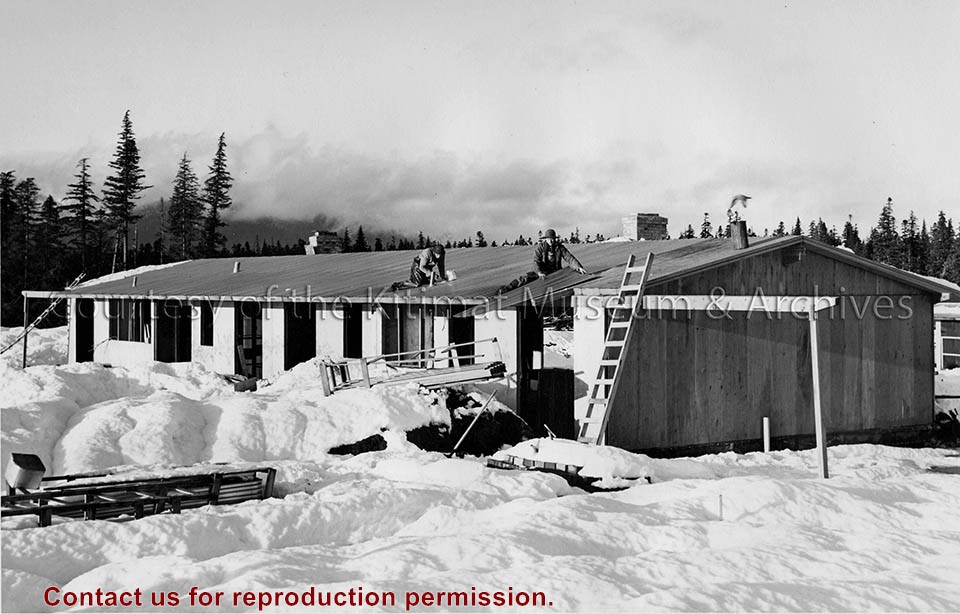
Photograph of looking south in block 20, Swallow Street, of the N.W. Hullah Construction housing units. Men visible working. Pipes laid on ground in front.
Donated by Jackie Worboys. Given to the Jackie Mufford Worboys family by Wally Melville.
Scope and Content
Photograph of looking south in block 20, Swallow Street, of the N.W. Hullah Construction housing units. Men visible working. Pipes laid on ground in front.