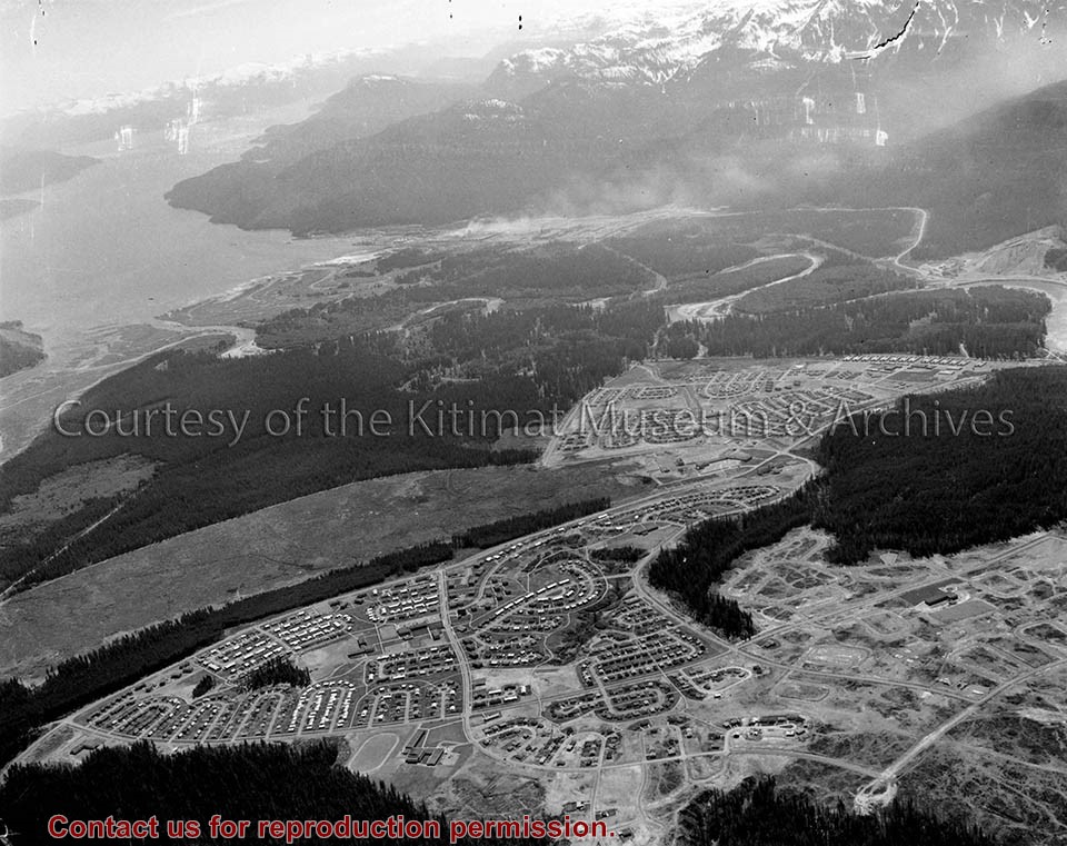
Large aerial view of Kitimat and the head of the Douglas Channel in 1964.
Notes
Approximate scale 1 inch to 320 feet. Aerial photography flown 30 June 1964 by Hunting Survey Corporation Limited for the Aluminum Company of Canada Limited.
Photograph of Aerial View of Nechako Neighborhood ; Kildala Neighborhood ; Highway 25/37 ; Mt. Elizabeth Secondary ; City Centre ; Minette Bay ; Kitimat General Hospital ; Municipal Cemetary
Photograph of Aerial View of Nechako Neighborhood ; Kildala Neighborhood ; Highway 25/37 ; Mt. Elizabeth Secondary ; City Centre ; Minette Bay ; Kitimat General Hospital ; Municipal Cemetary
Photograph of Aerial View of Riverlodge Camp ; Service Centre ; Haisla Bridge ; Sandhill ; Kitimat River ; Bowbyes Lake ; Parks and Campground ; Municipal Park and Campground, Radley
Photograph of Aerial View of Riverlodge Camp ; Service Centre ; Haisla Bridge ; Sandhill ; Kitimat River ; Bowbyes Lake ; Parks and Campground ; Municipal Park and Campground, Radley
Photograph of Aerial View of Riverlodge Camp ; Kildala Neighborhood ; City Centre ; Albatross Ave. ; Bittern, Cormorant Streets ; Kitimat River ; Parks and Campgrounds ; Municipal ; Radley Park
Photograph of Aerial View of Riverlodge Camp ; Kildala Neighborhood ; City Centre ; Albatross Ave. ; Bittern, Cormorant Streets ; Kitimat River ; Parks and Campgrounds ; Municipal ; Radley Park
Photograph of Aerial View of Whitesail, Nechako, Kildala Neighborhoods ; Hirsch Creek, Hirsch Creek Bridge ; 25 Highway ; Roy Wilcox Elementary School ; Kitimat General Hospital ; City Centre ; Water Tower ; Parks and Campgrounds ; Municipal ; Hirsch Creek Park
Photograph of Aerial View of Whitesail, Nechako, Kildala Neighborhoods ; Hirsch Creek, Hirsch Creek Bridge ; 25 Highway ; Roy Wilcox Elementary School ; Kitimat General Hospital ; City Centre ; Water Tower ; Parks and Campgrounds ; Municipal ; Hirsch Creek Park
Photograph of Aerial View of Smeltersite ; Alcan Smelter ; Potlines 1 and 2 ; Anderson Creek Camp ; Kitimat Yacht Club ; Kitimat Estuary ; Delta King ; Business ; Industrial ; Aluminum Co. of Canada
Photograph of Aerial View of Smeltersite ; Alcan Smelter ; Potlines 1 and 2 ; Anderson Creek Camp ; Kitimat Yacht Club ; Kitimat Estuary ; Delta King ; Business ; Industrial ; Aluminum Co. of Canada
Photograph of Aerial View of Kitimat River ; Haisla Bridge ; Kildala, Nechako, Whitesail Neighborhoods ; Sandhill ; Service Centre ; Parks and Campgrounds ; Municipal Campground, Radley
Photograph of Aerial View of Kitimat River ; Haisla Bridge ; Kildala, Nechako, Whitesail Neighborhoods ; Sandhill ; Service Centre ; Parks and Campgrounds ; Municipal Campground, Radley
Photograph of Aerial View of Kildala Neighborhood ; Riverlodge Camp ; Haisla Bridge ; Service Centre ; Kitimat General Hospital ; Kitimat River ; Sandhill ; Parks and Campgrounds ; Municipal Campground, Radley
Photograph of Aerial View of Kildala Neighborhood ; Riverlodge Camp ; Haisla Bridge ; Service Centre ; Kitimat General Hospital ; Kitimat River ; Sandhill ; Parks and Campgrounds ; Municipal Campground, Radley
Photograph of Aerial View of Service Centre ; Sandhill ; Haisla Bridge ; Kitimat River ; Riverlodge Camp ; Alcan Road ; Parks and Campgrounds ; Municipal Campground, Radley
Photograph of Aerial View of Service Centre ; Sandhill ; Haisla Bridge ; Kitimat River ; Riverlodge Camp ; Alcan Road ; Parks and Campgrounds ; Municipal Campground, Radley
Photograph of Aerial View of Service Centre ; Kildala, Nechako Neighborhoods ; Haisla Bridge ; Kitimat River ; Parks and Camp Grounds ; Municipal Campground, Radley ; Riverlodge Camp
Photograph of Aerial View of Service Centre ; Kildala, Nechako Neighborhoods ; Haisla Bridge ; Kitimat River ; Parks and Camp Grounds ; Municipal Campground, Radley ; Riverlodge Camp
Photograph of Aerial View of Kildala Neighborhoods ; City Centre ; Haisla Bridge ; Service Centre Kitimat River ; Whitesail Area (Clearing) Riverlodge Camp. Parks and Campgrounds ; Municipal Campground, Radley
Photograph of Aerial View of Kildala Neighborhoods ; City Centre ; Haisla Bridge ; Service Centre Kitimat River ; Whitesail Area (Clearing) Riverlodge Camp. Parks and Campgrounds ; Municipal Campground, Radley
Photo depicts an aerial view of Kitimat, seen is land cleared for Neighbourhood "D" and the Whitesail neighbourhood under construction, right foreground. The Alcan smelter and channel are in the background.
Photo depicts an aerial view of Kitimat, seen is land cleared for Neighbourhood "D" and the Whitesail neighbourhood under construction, right foreground. The Alcan smelter and channel are in the background.
Notes
Title based on content of photograph. Max Patzelt Collection - 1998.1.8351