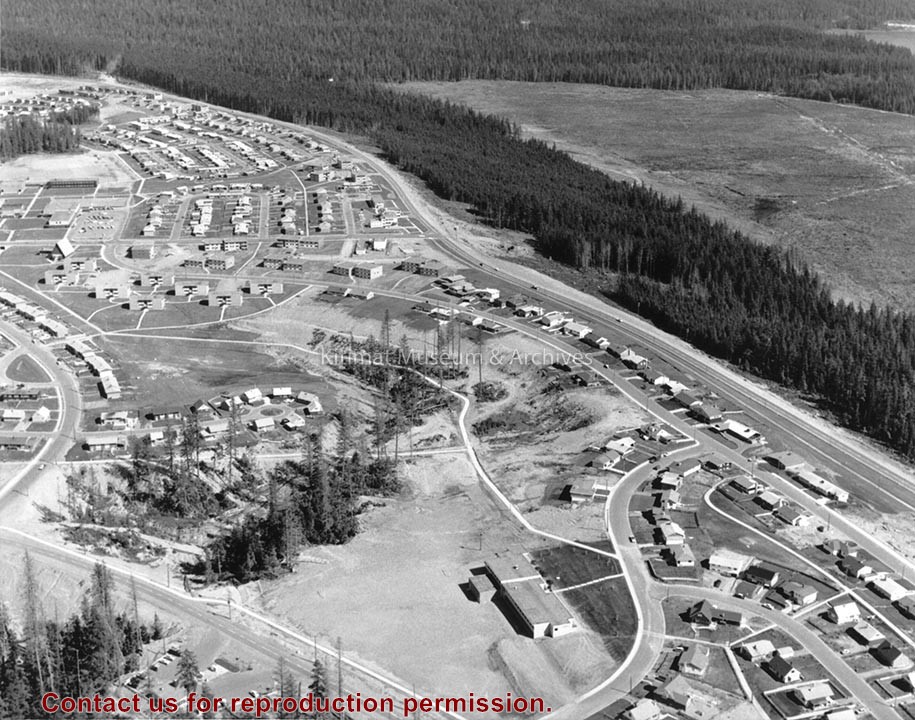
Photograph of aerial of the Nechako neighbourhood. View is looking west towards Squirrel and Clague mountains, which are in the background. On the front right, there is a watertower structure.
From the years 1953-1958, Mike Kinnear took photos during his school years, until graduation, while working for Fred Ryan Ltd. after school and holidays. Photos for him was a hobby, and he took many photos of the smelter and townsite as it grew around him. Mike also took a number of photos for the Kitimat Northern Sentinel, during the Ken Brumley and Pixie Meldrum years as editors. Mike and his family left Kitimat in 1958, but he spent the best part of 40 years in the photographic field, mainly in the retail/wholesale part of the photo industry.
Custodial History
Donated by Margaret and Mike Kinnear.
Scope and Content
Photograph of aerial of the Nechako neighbourhood. View is looking west towards Squirrel and Clague mountains, which are in the background. On the front right, there is a watertower structure.
Photograph of Aerial View of Nechako Neighborhood ; Kildala Neighborhood ; Whitesail Neighborhood ; City Centre ; Roy Wilcox School ; Water Tower ; Hirsch Creek ; Municipal Cemetary ; Mt. Elizabeth Secondary ; St. Anthony's Church / School
Photograph of Aerial View of Nechako Neighborhood ; Kildala Neighborhood ; Whitesail Neighborhood ; City Centre ; Roy Wilcox School ; Water Tower ; Hirsch Creek ; Municipal Cemetary ; Mt. Elizabeth Secondary ; St. Anthony's Church / School
Photograph of aerial of east side of Nechako area. Widgeon, Wren, Apartments, Partridge, and Pintail in foreground with more streets behind. Houses are built.
Donated by Jackie Worboys. Given to the Jackie Mufford Worboys family by Wally Melville.
Scope and Content
Photograph of aerial of east side of Nechako area. Widgeon, Wren, Apartments, Partridge, and Pintail in foreground with more streets behind. Houses are built.
Photograph of aerial of west side of Nechako area. Petrel, Plover, Aprtments, Osprey and Oriole in foreground with more streets behind. Houses are built. Fire station, United Church, Nechako Centre and School are visible.
Donated by Jackie Worboys. Given to the Jackie Mufford Worboys family by Wally Melville.
Scope and Content
Photograph of aerial of west side of Nechako area. Petrel, Plover, Aprtments, Osprey and Oriole in foreground with more streets behind. Houses are built. Fire station, United Church, Nechako Centre and School are visible.
Photograph of Aerial View of Whitesail Neighborhood ; Mt. Elizabeth Secondary School ; Hirsch Creek ; Highway 25 ; Parks and Campgrounds ; Municipal Campgrounds ; Hirsch Creek
Photograph of Aerial View of Whitesail Neighborhood ; Mt. Elizabeth Secondary School ; Hirsch Creek ; Highway 25 ; Parks and Campgrounds ; Municipal Campgrounds ; Hirsch Creek
Photograph of aerial photograph looking east toward neighbourhood A with the City Centre clearing in the right-hand foreground and neighbourhood A-IV clearing in the centre foreground.
Donated by Jackie Worboys. Given to the Jackie Mufford Worboys family by Wally Melville.
Scope and Content
Photograph of aerial photograph looking east toward neighbourhood A with the City Centre clearing in the right-hand foreground and neighbourhood A-IV clearing in the centre foreground.
Aerial view of Nechako Neighbourhood looking east. looking east. Note clearing for B-III on left side of picture and clearing for City Centre and Neighbourhood D on the right side.
Aerial view of Nechako Neighbourhood looking east. looking east. Note clearing for B-III on left side of picture and clearing for City Centre and Neighbourhood D on the right side.
Photograph of aerial view looking east across neighbourhood A-III and A-I. Note in upper left centre a portion of the concrete walks already constructed, which eventually will lead to Kingfisher underpass. Also note contrast between landscaped areas and those surrounding the houses now under construction. Gyrfaclon street in centre. Nechako Centre and School visible at upper left. Nechako school has protables outside.
Donated by Jackie Worboys. Given to the Jackie Mufford Worboys family by Wally Melville.
Scope and Content
Photograph of aerial view looking east across neighbourhood A-III and A-I. Note in upper left centre a portion of the concrete walks already constructed, which eventually will lead to Kingfisher underpass. Also note contrast between landscaped areas and those surrounding the houses now under construction. Gyrfaclon street in centre. Nechako Centre and School visible at upper left. Nechako school has protables outside.
Photograph of aerial view looking north-east across neighbourhood A-I with Petrel and Oriole Streets in the foreground. Nechako Centre and School visible behind.
Donated by Jackie Worboys. Given to the Jackie Mufford Worboys family by Wally Melville.
Scope and Content
Photograph of aerial view looking north-east across neighbourhood A-I with Petrel and Oriole Streets in the foreground. Nechako Centre and School visible behind.