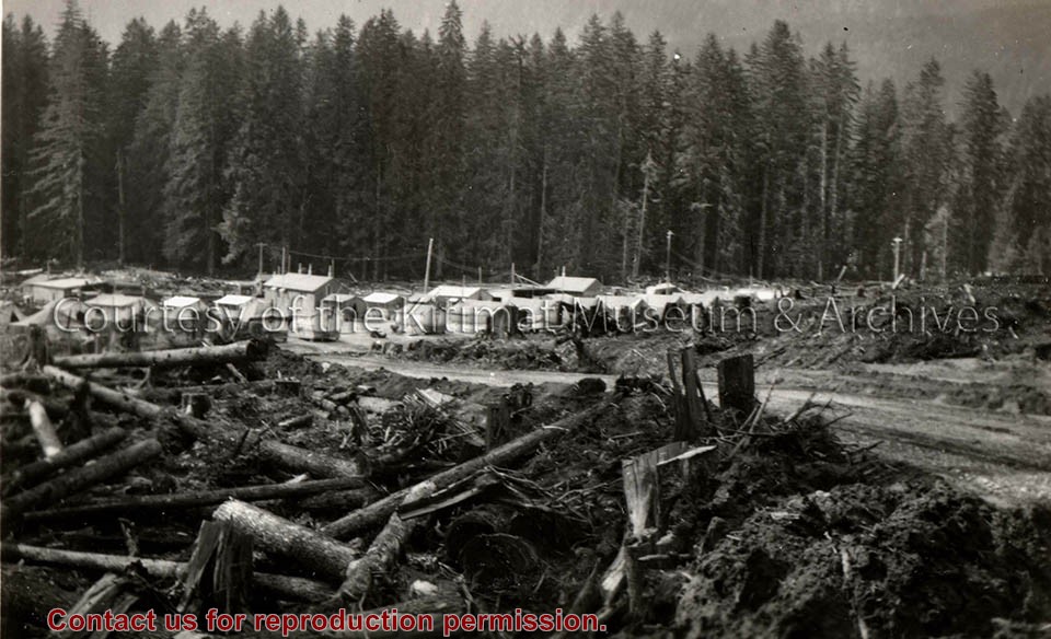
Photograph of a cleared out area. Small house and logging truck on right. Another small house is a bit further back with two standing poles near it. Ground is wet.
Donated by Jackie Worboys. Given to the Jackie Mufford Worboys family by Wally Melville.
Scope and Content
Photograph of a cleared out area. Small house and logging truck on right. Another small house is a bit further back with two standing poles near it. Ground is wet.
Photograph of a logging truck in a cleared out area. Man is standing on the truck. Two standing poles visible behind truck. Two small buildings to the right with a sign on one reading "Mary's Inn." Ground is wet.
Donated by Jackie Worboys. Given to the Jackie Mufford Worboys family by Wally Melville.
Scope and Content
Photograph of a logging truck in a cleared out area. Man is standing on the truck. Two standing poles visible behind truck. Two small buildings to the right with a sign on one reading "Mary's Inn." Ground is wet.
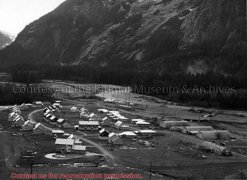
Photo depicts the permanent Kemano townsite at Camp No. 5. View is looking towards beach. Seen on the left are permanent homes for powerhouse staff. On the right are the temporary buildings known as quonset huts used during the construction years as crew quarters.
Photo depicts the permanent Kemano townsite at Camp No. 5. View is looking towards beach. Seen on the left are permanent homes for powerhouse staff. On the right are the temporary buildings known as quonset huts used during the construction years as crew quarters.
Notes
Title based on content of photograph. -- Alcan ID No. 2KR-298. -- Permanent housing construction began in 1957. Alcan Collection
Photograph of looking east showing the clearing operations north of Haisla Boulevard. Note falling operations in the Hospital site. Cranes in cleared area, and vehicles on the road to the right. Smokes visible in center.
Photos belonged to Raymond Stanyer who worked in Kitimat, and were donated by his wife, Pat Stanyer
Scope and Content
Photograph of looking east showing the clearing operations north of Haisla Boulevard. Note falling operations in the Hospital site. Cranes in cleared area, and vehicles on the road to the right. Smokes visible in center.
Photograph of the clearing operations north of Haisla boulevard. Falling operations in the hospital site. Smoke in middle and cars in the road to the right.
Land clearing of Kitimat. All aerials for development.
Custodial History
From the files of Ray Hunstone. Photos from an Alcan binder, have Alcan numbers.
Scope and Content
Photograph of the clearing operations north of Haisla boulevard. Falling operations in the hospital site. Smoke in middle and cars in the road to the right.
Photograph of aerial view looking west showing C-II clearing in lower left hand corner, low rental housing area and neighbourhood C-I in centre, and new camp site clearing left-centre. Camp is at Riverlodge site. Kitimat River bridge visible behind. Lots of snow on ground.
Donated by Jackie Worboys. Given to the Jackie Mufford Worboys family by Wally Melville.
Scope and Content
Photograph of aerial view looking west showing C-II clearing in lower left hand corner, low rental housing area and neighbourhood C-I in centre, and new camp site clearing left-centre. Camp is at Riverlodge site. Kitimat River bridge visible behind. Lots of snow on ground.
Photograph of aerial photograph taken from over townsite camp looking toward City Centre showing extent of clearing in C-I area. Haisla Blvd. can be seen on left-hand side of the picture. At bottom a single structure can be seen. Some snow is behind it. In the very back Douglas Channel is visible.
Donated by Jackie Worboys. Given to the Jackie Mufford Worboys family by Wally Melville.
Scope and Content
Photograph of aerial photograph taken from over townsite camp looking toward City Centre showing extent of clearing in C-I area. Haisla Blvd. can be seen on left-hand side of the picture. At bottom a single structure can be seen. Some snow is behind it. In the very back Douglas Channel is visible.
Photograph of land clearing operation in neighbourhood C-II. Sewer line under construction in foreground is part of extension to Sagimat temporary housing. Pipe segments in foreground.
Land clearing of Kitimat. All aerials for development.
Custodial History
From the files of Ray Hunstone. Photos from an Alcan binder, have Alcan numbers.
Scope and Content
Photograph of land clearing operation in neighbourhood C-II. Sewer line under construction in foreground is part of extension to Sagimat temporary housing. Pipe segments in foreground.
Photograph of gully crossing #2 showing the clearing contractor placing the dead and diseased trees at the base of the gully to stop any further earth slippage and improve the appearance of the area. Houses visble on hill behind.
Land clearing of Kitimat. All aerials for development.
Custodial History
From the files of Ray Hunstone. Photos from an Alcan binder, have Alcan numbers.
Scope and Content
Photograph of gully crossing #2 showing the clearing contractor placing the dead and diseased trees at the base of the gully to stop any further earth slippage and improve the appearance of the area. Houses visble on hill behind.