A man presenting a trophy to a hockey team in the arena. The man is standing on the left, and is shaking hands with a hockey player in the front. The young boy to the right has his hands in his pocket, and is wearing a jacket with a "Kitimat Home Service" Logo.
A man presenting a trophy to a hockey team in the arena. The man is standing on the left, and is shaking hands with a hockey player in the front. The young boy to the right has his hands in his pocket, and is wearing a jacket with a "Kitimat Home Service" Logo.
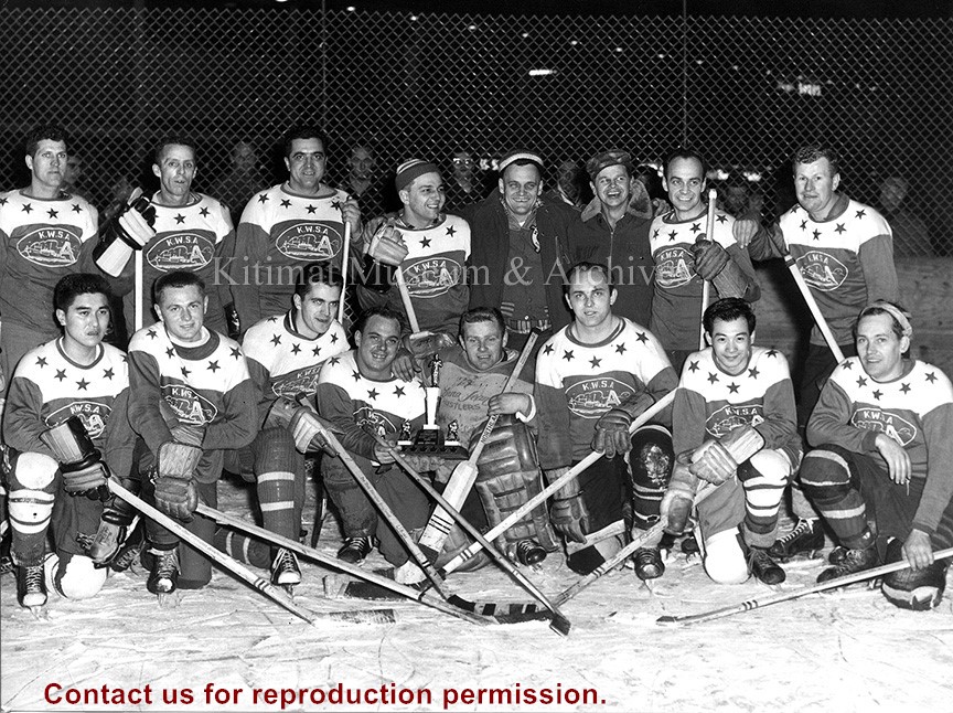
Photo showing victorious "A" Shift ice hockey team, back row from left: Laurie Leblanc, Jim Adams, Eddy Kratz, Bert Sauteur, Ray LaPointe, Harold Johanson, Denis Marleau, Jerry Chancey. Front row; Gus Ishida, Merv Michaluk, Fred Wowk, Bill Benz, Willy Reid, George Eisner, Kenny Hamanishi, Dolmar Anderson.
Current: 1960s
- Sports
- League Play
- Adult Ice Hockey
Scope and Content
Photo showing victorious "A" Shift ice hockey team, back row from left: Laurie Leblanc, Jim Adams, Eddy Kratz, Bert Sauteur, Ray LaPointe, Harold Johanson, Denis Marleau, Jerry Chancey. Front row; Gus Ishida, Merv Michaluk, Fred Wowk, Bill Benz, Willy Reid, George Eisner, Kenny Hamanishi, Dolmar Anderson.
Aerial picture showing Riverlodge under construction. Note piles in place for Mess Hall and single room dormitories and grading being undertaken on Rec. Hall and Rec. Field sites
Aerial picture showing Riverlodge under construction. Note piles in place for Mess Hall and single room dormitories and grading being undertaken on Rec. Hall and Rec. Field sites
Photo depicts an aerial view of Kitimat. Seen is land cleared for Neighbourhood "D" and the Whitesail Neighbourhood under construction, right foreground. The Alcan smelter and channel are in the background.
Photo depicts an aerial view of Kitimat. Seen is land cleared for Neighbourhood "D" and the Whitesail Neighbourhood under construction, right foreground. The Alcan smelter and channel are in the background.
Notes
Title based on content of photograph. -- On the official "Town Plan for Kitimat, B.C." by Stein and Mayer & Whittlesey, Neighbourhood "D", the cleared area in the photo, was to have three elementary schools, and one junior and one senior high school. This neighbourhood was never constructed and was returned to bush.
Aerial photo of the Kitimat Region. Includes the Kitimat estuary, the Alcan smelter site and in the distance, the Kitimat City Centre. Taken from the southwest.
Aerial photo of the Kitimat Region. Includes the Kitimat estuary, the Alcan smelter site and in the distance, the Kitimat City Centre. Taken from the southwest.
Aerial photo of the Kitimat river estuary showing Kitimat River, Kitimat Harbor, Minette Bay, and the Alcan company smelter site taken from the southwest looking northeast towards the Kitimat City Centre.
Aerial photo of the Kitimat river estuary showing Kitimat River, Kitimat Harbor, Minette Bay, and the Alcan company smelter site taken from the southwest looking northeast towards the Kitimat City Centre.
Aerial view of a portion of Neighbourhood B-I with Road "C" in the foreground. Note small timber fire near Hirsch Creek in upper left hand side of the photograph.
Aerial view of a portion of Neighbourhood B-I with Road "C" in the foreground. Note small timber fire near Hirsch Creek in upper left hand side of the photograph.