Aerial view of the townsite clearing looking North. Note, City Centre in left foreground with clearing for main sewer outfall extending across to the lower right hand corner of photograph
Aerial view of the townsite clearing looking North. Note, City Centre in left foreground with clearing for main sewer outfall extending across to the lower right hand corner of photograph
Photograph of aerial view of the Kitimat townsite. In the upper portion Nechako neighbourhood is visible. Below is the Kildala neighbourhhod clearing, and the riverside camp is visible on the right. Mount Elizabeth is in the background.
From the years 1953-1958, Mike Kinnear took photos during his school years, until graduation, while working for Fred Ryan Ltd. after school and holidays. Photos for him was a hobby, and he took many photos of the smelter and townsite as it grew around him. Mike also took a number of photos for the Kitimat Northern Sentinel, during the Ken Brumley and Pixie Meldrum years as editors. Mike and his family left Kitimat in 1958, but he spent the best part of 40 years in the photographic field, mainly in the retail/wholesale part of the photo industry.
Custodial History
Donated by Margaret and Mike Kinnear.
Scope and Content
Photograph of aerial view of the Kitimat townsite. In the upper portion Nechako neighbourhood is visible. Below is the Kildala neighbourhhod clearing, and the riverside camp is visible on the right. Mount Elizabeth is in the background.
Notes
Back of photo is stamped by Ansco Printon Munshaw Colour Service Ltd.
Photograph of aerial view looking northwest across Kitimat townsite. B-I & B-II clearing in right hand side of picture. Site of watertowers? visible on far right.
Photos belonged to Raymond Stanyer who worked in Kitimat, and were donated by his wife, Pat Stanyer
Scope and Content
Photograph of aerial view looking northwest across Kitimat townsite. B-I & B-II clearing in right hand side of picture. Site of watertowers? visible on far right.
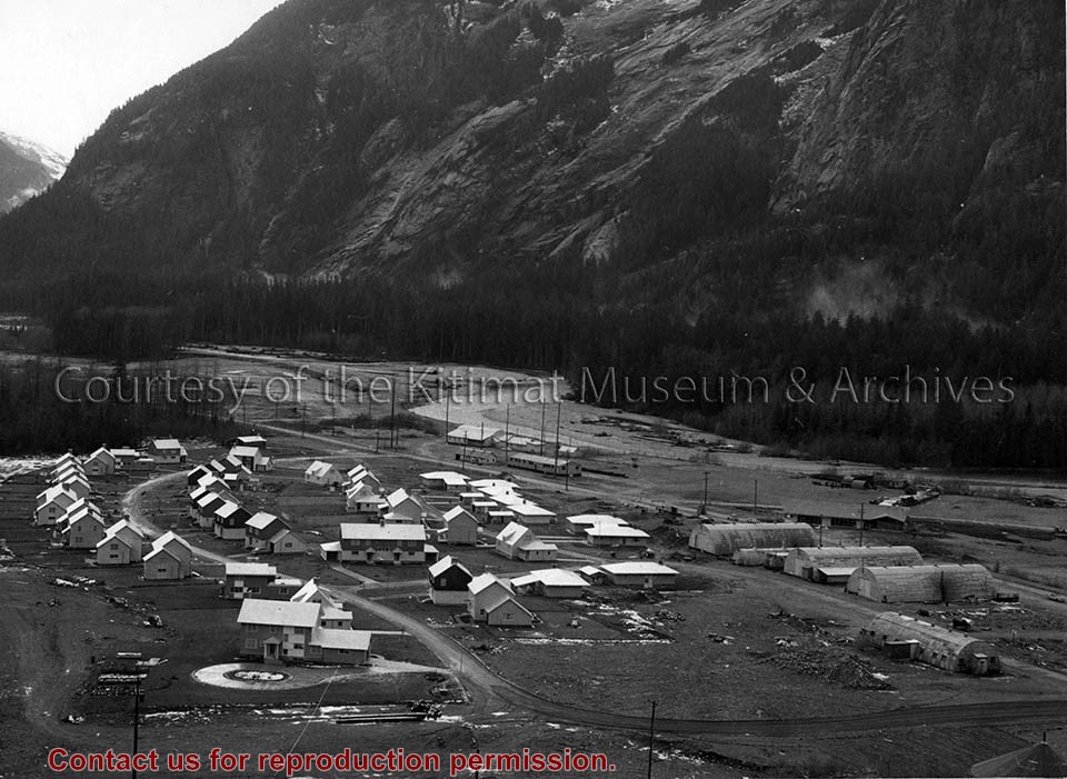
Photo depicts the permanent Kemano townsite at Camp No. 5. View is looking towards beach. Seen on the left are permanent homes for powerhouse staff. On the right are the temporary buildings known as quonset huts used during the construction years as crew quarters.
Photo depicts the permanent Kemano townsite at Camp No. 5. View is looking towards beach. Seen on the left are permanent homes for powerhouse staff. On the right are the temporary buildings known as quonset huts used during the construction years as crew quarters.
Notes
Title based on content of photograph. -- Alcan ID No. 2KR-298. -- Permanent housing construction began in 1957. Alcan Collection
Edwin Charles Bateman (Ted) was a Commando in WWII, and later enjoyed his hobbies of cycle racing, ballroom dancing, and photography. He lived in Toronto, LA, and finally Vancouver in the early 50s. After arriving in vancouver he was offered a job as an assistant surveyor in Kitimat. He was subsequently offered a job as a lineman with what became BC Tel.
Custodial History
Judith Saunders
Scope and Content
Photograph of aerial view of townsite clearing and Haisla bridge.
Edwin Charles Bateman (Ted) was a Commando in WWII, and later enjoyed his hobbies of cycle racing, ballroom dancing, and photography. He lived in Toronto, LA, and finally Vancouver in the early 50s. After arriving in vancouver he was offered a job as an assistant surveyor in Kitimat. He was subsequently offered a job as a lineman with what became BC Tel.
Custodial History
Judith Saunders
Scope and Content
Photograph of aerial view of townsite clearing and Haisla bridge, and service centre.
Edwin Charles Bateman (Ted) was a Commando in WWII, and later enjoyed his hobbies of cycle racing, ballroom dancing, and photography. He lived in Toronto, LA, and finally Vancouver in the early 50s. After arriving in vancouver he was offered a job as an assistant surveyor in Kitimat. He was subsequently offered a job as a lineman with what became BC Tel.
Custodial History
Judith Saunders
Scope and Content
Photograph of aerial view of townsite clearing. Built homes can be seen.
Photograph of an aerial of the Kitimat townsite. Focus is on the Nechako neighbourhood, and homes are already built. Hirsch Creek visible behind. Edge of plane visible on upper right.
From the years 1953-1958, Mike Kinnear took photos during his school years, until graduation, while working for Fred Ryan Ltd. after school and holidays. Photos for him was a hobby, and he took many photos of the smelter and townsite as it grew around him. Mike also took a number of photos for the Kitimat Northern Sentinel, during the Ken Brumley and Pixie Meldrum years as editors. Mike and his family left Kitimat in 1958, but he spent the best part of 40 years in the photographic field, mainly in the retail/wholesale part of the photo industry.
Custodial History
Donated by Margaret and Mike Kinnear.
Scope and Content
Photograph of an aerial of the Kitimat townsite. Focus is on the Nechako neighbourhood, and homes are already built. Hirsch Creek visible behind. Edge of plane visible on upper right.
Photograph of an aerial of the Kitimat townsite. Clearing for Kildala is in the front, and Lahakas and Haisla boulevard are going up to the Nechako area in the back. Some smoke is coming up from the Kildala area. Snowy mountain in background. Part of airplane visible on top of picture.
From the years 1953-1958, Mike Kinnear took photos during his school years, until graduation, while working for Fred Ryan Ltd. after school and holidays. Photos for him was a hobby, and he took many photos of the smelter and townsite as it grew around him. Mike also took a number of photos for the Kitimat Northern Sentinel, during the Ken Brumley and Pixie Meldrum years as editors. Mike and his family left Kitimat in 1958, but he spent the best part of 40 years in the photographic field, mainly in the retail/wholesale part of the photo industry.
Custodial History
Donated by Margaret and Mike Kinnear.
Scope and Content
Photograph of an aerial of the Kitimat townsite. Clearing for Kildala is in the front, and Lahakas and Haisla boulevard are going up to the Nechako area in the back. Some smoke is coming up from the Kildala area. Snowy mountain in background. Part of airplane visible on top of picture.
Photograph of aerial of the Kitimat townsite. View is looking over the Kildala neighbourhood with City Centre and the hospital visible beyond. Nechako and Whitesail neighbourhoods can be seen up on the hill. Mountains behind the town look clearcut. Mount Elizabeth furthest back in background.
Photograph of aerial of the Kitimat townsite. View is looking over the Kildala neighbourhood with City Centre and the hospital visible beyond. Nechako and Whitesail neighbourhoods can be seen up on the hill. Mountains behind the town look clearcut. Mount Elizabeth furthest back in background.
Photograph of an aerial of the Kitimat Townsite. View is looking across the full town towards Douglas Channel. Hirsch Creek is visible in front of the town.
Photograph of an aerial of the Kitimat Townsite. View is looking across the full town towards Douglas Channel. Hirsch Creek is visible in front of the town.
Photograph of an aerial of the Kitimat Townsite. View is looking across the full town towards Douglas Channel. Hirsch Creek and Cable Car are visible in the foreground.
Photograph of an aerial of the Kitimat Townsite. View is looking across the full town towards Douglas Channel. Hirsch Creek and Cable Car are visible in the foreground.