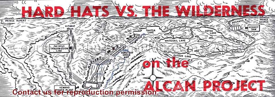
Illustration depicts a map of the Alcan project area, reaching from Prince Rupert to Kenney Dam. Seen is the transmission line, Kemano power plant and the lakes of the region.
Illustration depicts a map of the Alcan project area, reaching from Prince Rupert to Kenney Dam. Seen is the transmission line, Kemano power plant and the lakes of the region.
Notes
Clipping origin unknown. Fritz Wurster Collection. 2002.32
Photograph of foundation framework in place for Alcan commercial building in City Centre. Foundations in foreground are for the Hudson Bay building. Men are visible working.
Donated by Jackie Worboys. Given to the Jackie Mufford Worboys family by Wally Melville.
Scope and Content
Photograph of foundation framework in place for Alcan commercial building in City Centre. Foundations in foreground are for the Hudson Bay building. Men are visible working.
Photograph of aerial photograph looking west across neighbourhood C. Logs in lower right-hand corner are now being removed. In the background is the Riverlodge camp, with the dyke behind it. On top towards the right, the Kitimat River bridge is just visible.
Donated by Jackie Worboys. Given to the Jackie Mufford Worboys family by Wally Melville.
Scope and Content
Photograph of aerial photograph looking west across neighbourhood C. Logs in lower right-hand corner are now being removed. In the background is the Riverlodge camp, with the dyke behind it. On top towards the right, the Kitimat River bridge is just visible.
Photograph of sanitary sewer lines being installed by Straite Construction in Neighbourhood B across Lahakas Blvd. near Nalabila Blvd. Men are down in dug trench laying the pipes. Other men and machinery working above.
Donated by Jackie Worboys. Given to the Jackie Mufford Worboys family by Wally Melville.
Scope and Content
Photograph of sanitary sewer lines being installed by Straite Construction in Neighbourhood B across Lahakas Blvd. near Nalabila Blvd. Men are down in dug trench laying the pipes. Other men and machinery working above.