Subdivision plan of part of district lots 6038, 6039 and part of block 29, plan 3435 range 5, Coast District. District Municipality of Kitimat. Plan 4228. November 5, 1961.
Plan of subdivision of parts of D.L. 6046 & west half of D.L. 6045, and parcel. "X" (former block 78 and adjoining road plan 3549) range 5, Coast District. District Municipality of Kitimat. Plan 4639. August 27, 1963.
Plan of portions of block 29 map 3435 district lots 6038, 6039, 6042 & 6043 range 5, Coast District. District Municipality of Kitimat. Plan 3743. November 4, 1957.
Donated by Rick Wozney. Aluminum Company of Canada, Limited (Registered Owner).
Scope and Content
District of Kitimat lot and block plans.
Subdivision plan of part of district lots 6038, 6039 and part of block 29, plan 3435 range 5, Coast District. District Municipality of Kitimat. Plan 4228. November 5, 1961.
Plan of subdivision of parts of D.L. 6046 & west half of D.L. 6045, and parcel. "X" (former block 78 and adjoining road plan 3549) range 5, Coast District. District Municipality of Kitimat. Plan 4639. August 27, 1963.
Plan of portions of block 29 map 3435 district lots 6038, 6039, 6042 & 6043 range 5, Coast District. District Municipality of Kitimat. Plan 3743. November 4, 1957.
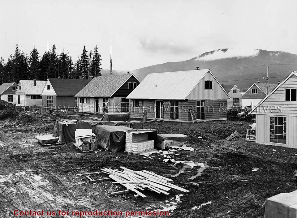
Collection of photographs regarding early Kitimat and Kitimat Constructors. Photo content includes Kitimat Constructors equipment work ares, shops, bunkhouses, and camp, Anderson Creek Mess Hall - smelterite, Inside Delta King, Sports girls and boys basketball, and Hudson's Bay Trading.
Collection of photographs regarding early Kitimat and Kitimat Constructors. Photo content includes Kitimat Constructors equipment work ares, shops, bunkhouses, and camp, Anderson Creek Mess Hall - smelterite, Inside Delta King, Sports girls and boys basketball, and Hudson's Bay Trading.
Photo depicts an aerial view of a portion of the Nechako neighbourhood showing the Hullah prototype area, Pintail and Partridge streets, in the foreground.
Photo depicts an aerial view of a portion of the Nechako neighbourhood showing the Hullah prototype area, Pintail and Partridge streets, in the foreground.
Notes
Title based on content of photograph. District of Kitimat Collection
Photographs of early Kitimat and Alcan smelter. Souvenir photobook with five photos.
Townsite with Mount Elizabeth in background. Smoke is visible beyond townsite in the forest. May 15, 1956.
Townsite with sandhill visible in background. May 15, 1956.
Main Road - Motel - Townsite. View of road leading from service centre into town. Kildala area cleared but not much is built. Kitimat River bridge visible at bottom. Aug 1955.
Kitimat Valley. View of Alcan site, hospital beach, and pier. Looking north.
Smeltersite. View of Alcan smelter and smeltersite.
Donated by Carol Larson. Originally belonged to her mother, Lydia Strecheniuk.
Scope and Content
Photographs of early Kitimat and Alcan smelter. Souvenir photobook with five photos.
Townsite with Mount Elizabeth in background. Smoke is visible beyond townsite in the forest. May 15, 1956.
Townsite with sandhill visible in background. May 15, 1956.
Main Road - Motel - Townsite. View of road leading from service centre into town. Kildala area cleared but not much is built. Kitimat River bridge visible at bottom. Aug 1955.
Kitimat Valley. View of Alcan site, hospital beach, and pier. Looking north.
Smeltersite. View of Alcan smelter and smeltersite.
Photograph of possibly line 1 potline left where carbon paste plant is today. Recreational facilities + a bit of the hill on the right where the homes were. Also, water tower.
Photograph of possibly line 1 potline left where carbon paste plant is today. Recreational facilities + a bit of the hill on the right where the homes were. Also, water tower.
Alice Dicker's father, Benard, came to Canada to work in 1955. He was a forman D-shift for Alcan. He married Anna in 1959. Alice and her sister Claudia were born in Kitimat and the family lived here until 1969, at which time they returned to Germany.
Scope and Content
Photograph of Nechako Centre. Shop-Easy store sign visible, and there are cars in parking lot. Tennis court is in front.
Base map of statistical area 6. The map shows Kitimat and surrounding coastal area. This map is a partial reproduction of the West Central British Columbia Base Map by Geographic Division, Surveys & Mapping Branch, Department of Lands, Forests, & Water Resources, Victoria, B.C. 1955-56.
Base map of statistical area 6. The map shows Kitimat and surrounding coastal area. This map is a partial reproduction of the West Central British Columbia Base Map by Geographic Division, Surveys & Mapping Branch, Department of Lands, Forests, & Water Resources, Victoria, B.C. 1955-56.